
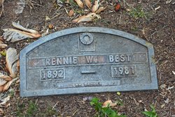
Rennie Winford Best
| Birth | : | 15 Oct 1892 Waterville, Douglas County, Washington, USA |
| Death | : | 1 Mar 1981 Brewster, Okanogan County, Washington, USA |
| Burial | : | Pateros Cemetery, Pateros, Okanogan County, USA |
| Coordinate | : | 48.0516600, -119.9097300 |
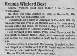
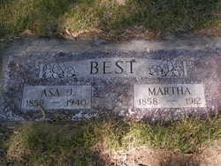
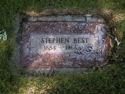
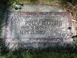
| Description | : | m: 28 Mar 1928 in Okanogan Co, WA Rennie Winford Best died March 1 in Brewster, Washington. Mr. Best was born October 15, 1892, in Waterville. His parents were Asa and Martha Best. He married Lois Yockey in Okanogan on March 28, 1928. He was a farmer and lived in the Methow Valley for many years, raising cattle and grain. He moved to Happy Hill and had also made his home in Republic and Okanogan. He is survived by two sisters, Polly Gobat, Pateros and Irma Smith, Mountain Home, Idaho; and numerous nephews and nieces. He was preceded in death by his wife and... Read More |
frequently asked questions (FAQ):
-
Where is Rennie Winford Best's memorial?
Rennie Winford Best's memorial is located at: Pateros Cemetery, Pateros, Okanogan County, USA.
-
When did Rennie Winford Best death?
Rennie Winford Best death on 1 Mar 1981 in Brewster, Okanogan County, Washington, USA
-
Where are the coordinates of the Rennie Winford Best's memorial?
Latitude: 48.0516600
Longitude: -119.9097300
Family Members:
Parent

Spouse
Siblings
Children
Flowers:


Nearby Cemetories:
1. Pateros Cemetery
Pateros, Okanogan County, USA
Coordinate: 48.0516600, -119.9097300
2. Dick Family Cemetery
Okanogan County, USA
Coordinate: 48.0502700, -119.9241700
3. Miller Family Cemetery
Okanogan County, USA
Coordinate: 48.0530300, -119.9288000
4. Packwood Memorial Cemetery
Dyer, Douglas County, USA
Coordinate: 48.0118305, -119.8178880
5. Methow Cemetery
Methow, Okanogan County, USA
Coordinate: 48.1102982, -120.0124969
6. Locust Grove Cemetery
Brewster, Okanogan County, USA
Coordinate: 48.1114006, -119.7746964
7. Paradise Hill Cemetery
Brewster, Okanogan County, USA
Coordinate: 48.1848980, -119.8411900
8. Elizabeth Osborn Mikel Gravesite
Brewster, Okanogan County, USA
Coordinate: 48.1498900, -119.7514700
9. Bridgeport Cemetery
Bridgeport, Douglas County, USA
Coordinate: 48.0050000, -119.6738800
10. Fort Okanogan Memorial Cemetery
Okanogan, Okanogan County, USA
Coordinate: 48.1594009, -119.6632996
11. Chelan Fraternal Cemetery
Chelan, Chelan County, USA
Coordinate: 47.8502998, -120.0081024
12. Mount Olivet Cemetery
Chelan, Chelan County, USA
Coordinate: 47.8451000, -119.9946000
13. Saint Andrews Episcopal Church
Chelan, Chelan County, USA
Coordinate: 47.8397460, -120.0183780
14. Riverview Cemetery
Chelan, Chelan County, USA
Coordinate: 47.8335991, -119.9944000
15. Manson Indian Cemetery
Manson, Chelan County, USA
Coordinate: 47.8800000, -120.1300000
16. Chiliwist Cemetery
Okanogan County, USA
Coordinate: 48.2630997, -119.7363968
17. Buckingham Cemetery
Douglas County, USA
Coordinate: 47.8669014, -119.6286011
18. Malott Community Cemetery
Malott, Okanogan County, USA
Coordinate: 48.2925000, -119.7047300
19. Beaver Creek Cemetery
Twisp, Okanogan County, USA
Coordinate: 48.3272000, -120.0564000
20. Mansfield Cemetery
Mansfield, Douglas County, USA
Coordinate: 47.8088880, -119.6508330
21. Ballard Family Cemetery
Stayman, Chelan County, USA
Coordinate: 47.7811100, -120.1133300
22. Fletcher Cemetery
Douglas County, USA
Coordinate: 47.7430992, -119.9403000
23. Cameron Lake Pioneer Memorial Cemetery
Malott, Okanogan County, USA
Coordinate: 48.2708330, -119.5700000
24. Jean Cemetery
Mansfield, Douglas County, USA
Coordinate: 47.8292999, -119.4916000