
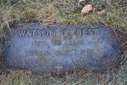
Watson Rooney Best
| Birth | : | 29 Jul 1899 Waterville, Douglas County, Washington, USA |
| Death | : | 1 Nov 1976 Brewster, Okanogan County, Washington, USA |
| Burial | : | Pateros Cemetery, Pateros, Okanogan County, USA |
| Coordinate | : | 48.0516600, -119.9097300 |
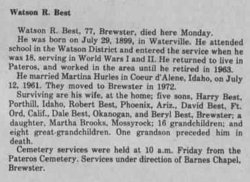
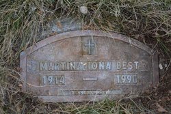
| Description | : | m: Florence Irene Smith 8 Feb 1921 in Camas Co, ID m: Nellie M Smith 5 May 1923 in Okanogan Co, WA m: Martina Brown 12 July 1961 in Kootenai Co, ID Walter R Best, 77, Brewster, died here Monday. He was born on July 29, 1899, in Waterville. He attended school in the Watson District and entered the service when he was 18, serving in World War II. He returned to live in Pateros and worked in the area until he retired in 1963. He married Martina Hurles in Coeur d'Alene, Idaho on July 12, 1961. They moved to Brewster in 1972. Surviving are his... Read More |
frequently asked questions (FAQ):
-
Where is Watson Rooney Best's memorial?
Watson Rooney Best's memorial is located at: Pateros Cemetery, Pateros, Okanogan County, USA.
-
When did Watson Rooney Best death?
Watson Rooney Best death on 1 Nov 1976 in Brewster, Okanogan County, Washington, USA
-
Where are the coordinates of the Watson Rooney Best's memorial?
Latitude: 48.0516600
Longitude: -119.9097300
Family Members:
Parent

Spouse
Siblings
Children
Flowers:


Nearby Cemetories:
1. Pateros Cemetery
Pateros, Okanogan County, USA
Coordinate: 48.0516600, -119.9097300
2. Dick Family Cemetery
Okanogan County, USA
Coordinate: 48.0502700, -119.9241700
3. Miller Family Cemetery
Okanogan County, USA
Coordinate: 48.0530300, -119.9288000
4. Packwood Memorial Cemetery
Dyer, Douglas County, USA
Coordinate: 48.0118305, -119.8178880
5. Methow Cemetery
Methow, Okanogan County, USA
Coordinate: 48.1102982, -120.0124969
6. Locust Grove Cemetery
Brewster, Okanogan County, USA
Coordinate: 48.1114006, -119.7746964
7. Paradise Hill Cemetery
Brewster, Okanogan County, USA
Coordinate: 48.1848980, -119.8411900
8. Elizabeth Osborn Mikel Gravesite
Brewster, Okanogan County, USA
Coordinate: 48.1498900, -119.7514700
9. Bridgeport Cemetery
Bridgeport, Douglas County, USA
Coordinate: 48.0050000, -119.6738800
10. Fort Okanogan Memorial Cemetery
Okanogan, Okanogan County, USA
Coordinate: 48.1594009, -119.6632996
11. Chelan Fraternal Cemetery
Chelan, Chelan County, USA
Coordinate: 47.8502998, -120.0081024
12. Mount Olivet Cemetery
Chelan, Chelan County, USA
Coordinate: 47.8451000, -119.9946000
13. Saint Andrews Episcopal Church
Chelan, Chelan County, USA
Coordinate: 47.8397460, -120.0183780
14. Riverview Cemetery
Chelan, Chelan County, USA
Coordinate: 47.8335991, -119.9944000
15. Manson Indian Cemetery
Manson, Chelan County, USA
Coordinate: 47.8800000, -120.1300000
16. Chiliwist Cemetery
Okanogan County, USA
Coordinate: 48.2630997, -119.7363968
17. Buckingham Cemetery
Douglas County, USA
Coordinate: 47.8669014, -119.6286011
18. Malott Community Cemetery
Malott, Okanogan County, USA
Coordinate: 48.2925000, -119.7047300
19. Beaver Creek Cemetery
Twisp, Okanogan County, USA
Coordinate: 48.3272000, -120.0564000
20. Mansfield Cemetery
Mansfield, Douglas County, USA
Coordinate: 47.8088880, -119.6508330
21. Ballard Family Cemetery
Stayman, Chelan County, USA
Coordinate: 47.7811100, -120.1133300
22. Fletcher Cemetery
Douglas County, USA
Coordinate: 47.7430992, -119.9403000
23. Cameron Lake Pioneer Memorial Cemetery
Malott, Okanogan County, USA
Coordinate: 48.2708330, -119.5700000
24. Jean Cemetery
Mansfield, Douglas County, USA
Coordinate: 47.8292999, -119.4916000