
| Birth | : | 18 Apr 1917 Danville, Yell County, Arkansas, USA |
| Death | : | 3 May 1975 Isleton, Sacramento County, California, USA |
| Burial | : | Sunset Lawn Chapel of the Chimes Memorial Park, Sacramento, Sacramento County, USA |
| Coordinate | : | 38.6514816, -121.4384842 |
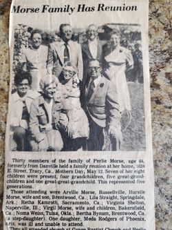
| Description | : | Retha Mae Elizabeth Morse, born on 18 April 1917, at Danville, Arkansas and died on 3 May 1975, at Isleton, California when her car went off the levy top road and into the Sacramento River. She was buried in the Sunset Lawn Cemetery's Rose Garden at Sacramento, California. She was the daughter of George Washington Morse (1876-1946) and his wife Pearlie Magnolia Nobblett (1890-1979). Retha's first marriage was to a gentleman with the surname of Payne and they had two children. She married again in 1949, at Reno, Nevada to Claude William Kamrath (1910-1971) and they had a son who was... Read More |
frequently asked questions (FAQ):
-
Where is Retha Mae Elizabeth Morse Kamrath's memorial?
Retha Mae Elizabeth Morse Kamrath's memorial is located at: Sunset Lawn Chapel of the Chimes Memorial Park, Sacramento, Sacramento County, USA.
-
When did Retha Mae Elizabeth Morse Kamrath death?
Retha Mae Elizabeth Morse Kamrath death on 3 May 1975 in Isleton, Sacramento County, California, USA
-
Where are the coordinates of the Retha Mae Elizabeth Morse Kamrath's memorial?
Latitude: 38.6514816
Longitude: -121.4384842
Family Members:
Parent

Spouse
Siblings
Children
Flowers:


Nearby Cemetories:
1. Kim Quang Temple Columbarium
Sacramento, Sacramento County, USA
Coordinate: 38.5996600, -121.3904700
2. Saint Marks Methodist Church Memorial Tree
Sacramento, Sacramento County, USA
Coordinate: 38.6076500, -121.3750680
3. Holy Ascension Russian Orthodox Cemetery
Sacramento, Sacramento County, USA
Coordinate: 38.5846212, -121.4936736
4. Saint Michaels Episcopal Church Columbarium
Carmichael, Sacramento County, USA
Coordinate: 38.6042800, -121.3547200
5. New Helvetia Cemetery (Defunct)
Sacramento, Sacramento County, USA
Coordinate: 38.5731600, -121.4639900
6. Trinity Episcopal Cathedral Columbarium
Sacramento, Sacramento County, USA
Coordinate: 38.5705500, -121.4723770
7. Union Cemetery
Roseville, Placer County, USA
Coordinate: 38.7302600, -121.3924200
8. California State Capitol
Sacramento, Sacramento County, USA
Coordinate: 38.5760994, -121.4931488
9. Carmichael Presbyterian Church Columbarium
Carmichael, Sacramento County, USA
Coordinate: 38.6179500, -121.3324500
10. East Lawn Memorial Park
Sacramento, Sacramento County, USA
Coordinate: 38.5612960, -121.4492760
11. Sierra Hills Pet Cemetery
Sacramento, Sacramento County, USA
Coordinate: 38.6863500, -121.3305300
12. Sierra Hills Memorial Park
Sacramento, Sacramento County, USA
Coordinate: 38.6843987, -121.3281021
13. National Shrine of Our Lady of Guadalupe Crypt
Sacramento, Sacramento County, USA
Coordinate: 38.5704800, -121.5014400
14. Buddhist Church of Sacramento Nokotsudo
Sacramento, Sacramento County, USA
Coordinate: 38.5639300, -121.4978400
15. Calvary Catholic Cemetery and Mausoleum
Sacramento, Sacramento County, USA
Coordinate: 38.6937180, -121.3233109
16. Saint Joseph Cemetery
Sacramento, Sacramento County, USA
Coordinate: 38.5574989, -121.4835968
17. Sacramento City Cemetery
Sacramento, Sacramento County, USA
Coordinate: 38.5636864, -121.5009537
18. Sunset Hill Cemetery
Sacramento, Sacramento County, USA
Coordinate: 38.5608000, -121.5037300
19. Masonic Lawn Cemetery
Sacramento, Sacramento County, USA
Coordinate: 38.5604720, -121.5032600
20. Odd Fellows Lawn Cemetery and Mausoleum
Sacramento, Sacramento County, USA
Coordinate: 38.5585000, -121.5011000
21. Pho Minh Temple Columbarium
Sacramento, Sacramento County, USA
Coordinate: 38.5340100, -121.4769000
22. Saint Mary's Catholic Cemetery and Mausoleum
Sacramento, Sacramento County, USA
Coordinate: 38.5298900, -121.4261200
23. Sacramento County Hospital Cemetery
Sacramento, Sacramento County, USA
Coordinate: 38.5289300, -121.4239100
24. Fair Oaks Cemetery
Fair Oaks, Sacramento County, USA
Coordinate: 38.6501167, -121.2792000