
Rev Hermon Clenney
| Birth | : | 18 Nov 1912 Scotts Hill, Decatur County, Tennessee, USA |
| Death | : | 21 Mar 2001 Cahokia, St. Clair County, Illinois, USA |
| Burial | : | Audenshaw Cemetery, Audenshaw, Metropolitan Borough of Tameside, England |
| Coordinate | : | 53.4653300, -2.1101560 |
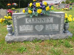
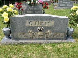
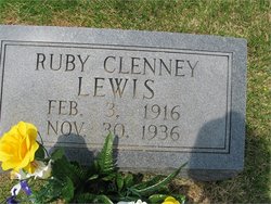
| Description | : | Rev. Clenney was a retired pastor for the Apostolic Jesus Name Church, St. Louis, Missouri. He was preceded in death by his parents, Walter C. and Lona, nee Norwood, Clenney; a brother, James F. Clenney; and two sisters, Ruby F. Lewis and Irlby M. Massey. Surviving are his wife, Willie Mae, nee Creasey, Clenney; two daughters, June A., widow of M.L. Short, of St. Charles, Missouri, and Sherlon Gail (William) Harrell of Scotts Hill, Tennessee; two brothers, Charles (Doris) Clenney of St. Louis, Missouri and Walter (Jeanice) Clenney of St. Louis, Missouri; two sisters, Irona Jan (Otis) Jones of Lexington,... Read More |
frequently asked questions (FAQ):
-
Where is Rev Hermon Clenney's memorial?
Rev Hermon Clenney's memorial is located at: Audenshaw Cemetery, Audenshaw, Metropolitan Borough of Tameside, England.
-
When did Rev Hermon Clenney death?
Rev Hermon Clenney death on 21 Mar 2001 in Cahokia, St. Clair County, Illinois, USA
-
Where are the coordinates of the Rev Hermon Clenney's memorial?
Latitude: 53.4653300
Longitude: -2.1101560
Family Members:
Parent

Spouse

Siblings

Flowers:


Nearby Cemetories:
1. Audenshaw Cemetery
Audenshaw, Metropolitan Borough of Tameside, England
Coordinate: 53.4653300, -2.1101560
2. Saint Stephens Churchyard
Audenshaw, Metropolitan Borough of Tameside, England
Coordinate: 53.4753000, -2.1151700
3. Christ Church Churchyard
Denton, Metropolitan Borough of Tameside, England
Coordinate: 53.4560270, -2.1218270
4. St Lawrence Church
Denton, Metropolitan Borough of Tameside, England
Coordinate: 53.4520000, -2.1109000
5. St. Peter's Churchyard
Ashton-Under-Lyne, Metropolitan Borough of Tameside, England
Coordinate: 53.4839340, -2.1054690
6. Dukinfield Cemetery and Crematorium
Dukinfield, Metropolitan Borough of Tameside, England
Coordinate: 53.4800300, -2.0857150
7. Denton Cemetery
Denton, Metropolitan Borough of Tameside, England
Coordinate: 53.4424140, -2.1115510
8. St John's Churchyard
Dukinfield, Metropolitan Borough of Tameside, England
Coordinate: 53.4771000, -2.0726000
9. St George Churchyard
Hyde, Metropolitan Borough of Tameside, England
Coordinate: 53.4466540, -2.0789750
10. Saint Thomas The Apostle Churchyard
Hyde, Metropolitan Borough of Tameside, England
Coordinate: 53.4509000, -2.0707000
11. St. John The Baptist Churchyard
Hyde, Metropolitan Borough of Tameside, England
Coordinate: 53.4548411, -2.0644712
12. St Mary's Churchyard
Hyde, Metropolitan Borough of Tameside, England
Coordinate: 53.4652400, -2.0599700
13. Droylsden Cemetery
Droylsden, Metropolitan Borough of Tameside, England
Coordinate: 53.4849400, -2.1529696
14. Gorton Cemetery
Manchester, Metropolitan Borough of Manchester, England
Coordinate: 53.4567080, -2.1632580
15. Hyde Cemetery
Hyde, Metropolitan Borough of Tameside, England
Coordinate: 53.4437910, -2.0684130
16. Bethel Chapel Chapelyard
Stalybridge, Metropolitan Borough of Tameside, England
Coordinate: 53.4820413, -2.0576195
17. Hyde Chapel Chapelyard
Gee Cross, Metropolitan Borough of Tameside, England
Coordinate: 53.4374900, -2.0728100
18. Holy Trinity Churchyard
Gee Cross, Metropolitan Borough of Tameside, England
Coordinate: 53.4393900, -2.0645500
19. St Georges Cemetery
Stalybridge, Metropolitan Borough of Tameside, England
Coordinate: 53.4873400, -2.0576800
20. St George's Old Churchyard
Stalybridge, Metropolitan Borough of Tameside, England
Coordinate: 53.4844700, -2.0538800
21. St. John the Evangelist Churchyard
Hurst, Metropolitan Borough of Tameside, England
Coordinate: 53.5001310, -2.0812490
22. Saint Mark Churchyard
Bredbury, Metropolitan Borough of Stockport, England
Coordinate: 53.4241160, -2.1051390
23. St Elisabeth Church
Reddish, Metropolitan Borough of Stockport, England
Coordinate: 53.4379400, -2.1633950
24. Hurst Cemetery
Ashton-Under-Lyne, Metropolitan Borough of Tameside, England
Coordinate: 53.5011590, -2.0727370