
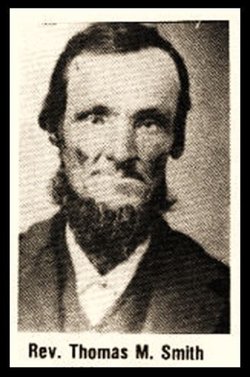
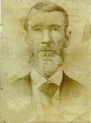
Rev Thomas Moble “TM” Smith
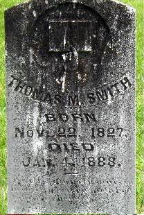
| Birth | : | 22 Nov 1827 Whitley County, Kentucky, USA |
| Death | : | 4 Jan 1888 Jellico, Campbell County, Tennessee, USA |
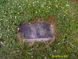
| Burial | : | Pleasington Cemetery and Crematorium, Blackburn, Blackburn with Darwen Unitary Authority, England |
| Coordinate | : | 53.7388880, -2.5368710 |
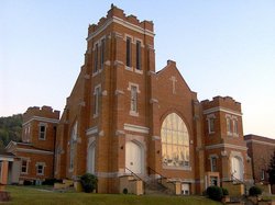
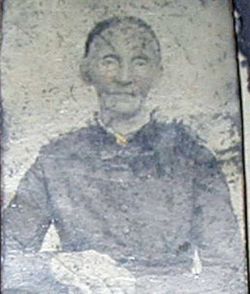
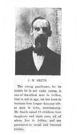
| Description | : | Confirmed Y DNA GRP R M269-42 R L-21 § By CL Hileman Thomas Moble Smith, son of James and Nancy Meadows Smith, was a farmer, Justice of the Peace, Baptist Minister, Post Master and a clerk in his family's mercantile. He served as first pastor of the First Baptist Church of Smithburg, later named Jellico, after contributing the land and donating to its construction. The original wood structure burned and later a larger brick church, built in its place, still stands on the Main Street of Jellico. He married first, Charlotte "Lottie" Cordell February 16, 1848,... Read More |
frequently asked questions (FAQ):
-
Where is Rev Thomas Moble “TM” Smith's memorial?
Rev Thomas Moble “TM” Smith's memorial is located at: Pleasington Cemetery and Crematorium, Blackburn, Blackburn with Darwen Unitary Authority, England.
-
When did Rev Thomas Moble “TM” Smith death?
Rev Thomas Moble “TM” Smith death on 4 Jan 1888 in Jellico, Campbell County, Tennessee, USA
-
Where are the coordinates of the Rev Thomas Moble “TM” Smith's memorial?
Latitude: 53.7388880
Longitude: -2.5368710
Family Members:
Parent
Spouse
Siblings
Children
Flowers:


Nearby Cemetories:
1. Pleasington Cemetery and Crematorium
Blackburn, Blackburn with Darwen Unitary Authority, England
Coordinate: 53.7388880, -2.5368710
2. Pleasington Priory
Pleasington, Blackburn with Darwen Unitary Authority, England
Coordinate: 53.7348590, -2.5433060
3. New Row Methodist Church
Blackburn with Darwen Unitary Authority, England
Coordinate: 53.7208950, -2.5023720
4. St Paul's
Blackburn, Blackburn with Darwen Unitary Authority, England
Coordinate: 53.7491222, -2.4891266
5. St. Peter's Churchyard
Blackburn, Blackburn with Darwen Unitary Authority, England
Coordinate: 53.7448110, -2.4865070
6. Holy Trinity Churchyard
Hoghton, Chorley Borough, England
Coordinate: 53.7279300, -2.5848550
7. St. Josephs Roman Catholic Churchyard
Brindle, Chorley Borough, England
Coordinate: 53.7350780, -2.5880640
8. Independent Chapel Churchyard
Blackburn, Blackburn with Darwen Unitary Authority, England
Coordinate: 53.7454960, -2.4864460
9. Wesleyan Methodist Chapel Chapelyard
Blackburn, Blackburn with Darwen Unitary Authority, England
Coordinate: 53.7464910, -2.4848380
10. Blackburn Cathedral
Blackburn, Blackburn with Darwen Unitary Authority, England
Coordinate: 53.7472960, -2.4820020
11. St. Mary's Churchyard
Mellor, Ribble Valley Borough, England
Coordinate: 53.7728600, -2.5312400
12. St Stephen Churchyard
Tockholes, Blackburn with Darwen Unitary Authority, England
Coordinate: 53.7058350, -2.5169320
13. Mellor Methodist Churchyard
Blackburn, Blackburn with Darwen Unitary Authority, England
Coordinate: 53.7742950, -2.5255060
14. Mount St Presbyterian Chapelyard
Blackburn, Blackburn with Darwen Unitary Authority, England
Coordinate: 53.7478000, -2.4775000
15. Holy Trinity Church
Blackburn with Darwen Unitary Authority, England
Coordinate: 53.7511727, -2.4747178
16. St Alban's Churchyard
Blackburn, Blackburn with Darwen Unitary Authority, England
Coordinate: 53.7530090, -2.4748540
17. St Mary's R.C. Church Cemetery
Osbaldeston, Ribble Valley Borough, England
Coordinate: 53.7816970, -2.5350240
18. St Paul's Churchyard
Withnell, Chorley Borough, England
Coordinate: 53.6970740, -2.5592150
19. St James Churchyard
Lower Darwen, Blackburn with Darwen Unitary Authority, England
Coordinate: 53.7245510, -2.4634700
20. Blackburn Cemetery
Blackburn, Blackburn with Darwen Unitary Authority, England
Coordinate: 53.7662430, -2.4726050
21. St Leonard Churchyard
Balderstone, Ribble Valley Borough, England
Coordinate: 53.7860070, -2.5609380
22. St James's Churchyard
Brindle, Chorley Borough, England
Coordinate: 53.7133333, -2.6086111
23. St. Mary's and St. John RC Churchyard, Southworth
Samlesbury, South Ribble Borough, England
Coordinate: 53.7676690, -2.6183400
24. St. Leonard the Less Churchyard
Samlesbury, South Ribble Borough, England
Coordinate: 53.7680000, -2.6237000