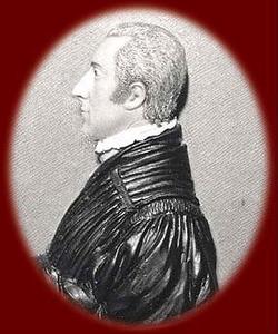
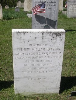
Rev William Emerson Sr.
| Birth | : | 31 May 1743 Malden, Middlesex County, Massachusetts, USA |
| Death | : | 20 Oct 1776 Rutland, Rutland County, Vermont, USA |
| Burial | : | Portsmouth Naval Memorial, Portsmouth, Portsmouth Unitary Authority, England |
| Coordinate | : | 50.7824440, -1.0957720 |
| Description | : | Revolutionary War Figure. He was the minister in the town of Concord, Massachusetts, from 1765 to 1776. In 1770, near the soon-to-be-famous North Bridge in that town he built his home, which would later become known as the "Old Manse." From his pulpit he preached resistance to oppression by the English Parliament. On April 19, 1775, the first day of the American Revolution, he pleaded with the leaders of the American militia to launch an immediate attack on the British regulars instead of waiting for reinforcements. His demands were ignored, but when the fighting did begin, Emerson anxiously watched the... Read More |
frequently asked questions (FAQ):
-
Where is Rev William Emerson Sr.'s memorial?
Rev William Emerson Sr.'s memorial is located at: Portsmouth Naval Memorial, Portsmouth, Portsmouth Unitary Authority, England.
-
When did Rev William Emerson Sr. death?
Rev William Emerson Sr. death on 20 Oct 1776 in Rutland, Rutland County, Vermont, USA
-
Where are the coordinates of the Rev William Emerson Sr.'s memorial?
Latitude: 50.7824440
Longitude: -1.0957720
Family Members:
Parent
Spouse
Siblings
Children
Flowers:
Nearby Cemetories:
1. Portsmouth Naval Memorial
Portsmouth, Portsmouth Unitary Authority, England
Coordinate: 50.7824440, -1.0957720
2. Royal Garrison Church Churchyard
Plymouth, Plymouth Unitary Authority, England
Coordinate: 50.7889690, -1.1039650
3. Royal Garrison Churchyard
Portsmouth, Portsmouth Unitary Authority, England
Coordinate: 50.7890180, -1.1040520
4. Portsmouth Cathedral Churchyard
Portsmouth, Portsmouth Unitary Authority, England
Coordinate: 50.7904650, -1.1043720
5. Portsmouth Unitarian Church
Portsmouth, Portsmouth Unitary Authority, England
Coordinate: 50.7915640, -1.1011840
6. Old Jewish Cemetery
Portsmouth, Portsmouth Unitary Authority, England
Coordinate: 50.7887000, -1.0738800
7. HMS Victoria Monument
Portsmouth, Portsmouth Unitary Authority, England
Coordinate: 50.7997200, -1.0950800
8. Highland Road Cemetery
Portsmouth, Portsmouth Unitary Authority, England
Coordinate: 50.7860500, -1.0671790
9. Holy Trinity Churchyard
Gosport, Gosport Borough, England
Coordinate: 50.7930600, -1.1207620
10. HMS Victory Ship
Portsmouth, Portsmouth Unitary Authority, England
Coordinate: 50.8017290, -1.1095590
11. St. Mary's Churchyard
Portsea, Portsmouth Unitary Authority, England
Coordinate: 50.8035350, -1.0763490
12. Clayhall Naval Cemetery
Gosport, Gosport Borough, England
Coordinate: 50.7833862, -1.1373420
13. St James Churchyard
Eastney, Portsmouth Unitary Authority, England
Coordinate: 50.7940650, -1.0581150
14. Turkish Naval Cemetery
Gosport, Gosport Borough, England
Coordinate: 50.7840710, -1.1383980
15. Kingston Cemetery
Portsmouth, Portsmouth Unitary Authority, England
Coordinate: 50.8031440, -1.0683260
16. Milton Cemetery
Portsmouth, Portsmouth Unitary Authority, England
Coordinate: 50.7988700, -1.0608030
17. Mile End Cemetery
Portsea, Portsmouth Unitary Authority, England
Coordinate: 50.8108900, -1.0876400
18. St. Mark's Churchyard
Alverstoke, Gosport Borough, England
Coordinate: 50.7826800, -1.1436100
19. St John the Evangelist Churchyard
Gosport, Gosport Borough, England
Coordinate: 50.7995600, -1.1397800
20. St Mary Churchyard
Alverstoke, Gosport Borough, England
Coordinate: 50.7856760, -1.1480810
21. Ann's Hill Cemetery
Gosport, Gosport Borough, England
Coordinate: 50.7982670, -1.1549450
22. St Thomas the Apostle Churchyard
Gosport, Gosport Borough, England
Coordinate: 50.8137570, -1.1484570
23. St. Mary's Churchyard
Portchester, Fareham Borough, England
Coordinate: 50.8366280, -1.1134270
24. St Mary the Virgin Churchyard
Gosport, Gosport Borough, England
Coordinate: 50.8112690, -1.1724800


