
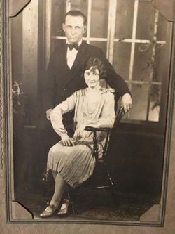
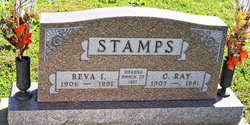
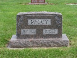
Reva Irene McCoy Stamps
| Birth | : | 10 Oct 1906 Taylor County, Iowa, USA |
| Death | : | 20 Sep 1991 Villisca, Montgomery County, Iowa, USA |
| Burial | : | Wellow & Shoscombe Cemetery, Wellow, Bath and North East Somerset Unitary Authority, England |
| Coordinate | : | 51.3165527, -2.3916632 |
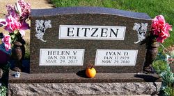
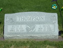
| Description | : | Clarinda Herald Journal (Clarinda, Iowa), Monday, September 23, 1991, p. 2 Reva Stamps – Mrs. Reva Stamps, 84, of rural Gravity, died early Friday morning, September 20, 1991 at Good Samaritan Nursing Home in Villisca. She was born October 10, 1906 in Taylor County, the daughter of Curt and Maude Negley McCoy. On March 20, 1927 she was married to Ray Stamps who preceded her in death May 6, 1991. Mrs. Stamps was a homemaker and farmed with her husband in the Gravity area. Survivors include seven children: Mrs. Ivan (Helen) Eitzen, Coin; Dean Stamps, Corning; Curtis Stamps, Diagonal; Mrs. Dean (Ruth) Thompson,... Read More |
frequently asked questions (FAQ):
-
Where is Reva Irene McCoy Stamps's memorial?
Reva Irene McCoy Stamps's memorial is located at: Wellow & Shoscombe Cemetery, Wellow, Bath and North East Somerset Unitary Authority, England.
-
When did Reva Irene McCoy Stamps death?
Reva Irene McCoy Stamps death on 20 Sep 1991 in Villisca, Montgomery County, Iowa, USA
-
Where are the coordinates of the Reva Irene McCoy Stamps's memorial?
Latitude: 51.3165527
Longitude: -2.3916632
Family Members:
Parent

Spouse

Siblings
Children
Flowers:


Nearby Cemetories:
1. Wellow & Shoscombe Cemetery
Wellow, Bath and North East Somerset Unitary Authority, England
Coordinate: 51.3165527, -2.3916632
2. St Julian's Churchyard
Wellow, Bath and North East Somerset Unitary Authority, England
Coordinate: 51.3240160, -2.3717630
3. Ashgrove Cemetery
Peasedown St John, Bath and North East Somerset Unitary Authority, England
Coordinate: 51.3181600, -2.4150760
4. Foxcote St James' The Less Churchyard
Shoscombe, Bath and North East Somerset Unitary Authority, England
Coordinate: 51.2985762, -2.4092987
5. St. James the Less Churchyard
Foxcote, Mendip District, England
Coordinate: 51.2985540, -2.4093370
6. Combe Hay Parish Churchyard
Combe Hay, Bath and North East Somerset Unitary Authority, England
Coordinate: 51.3371120, -2.3817390
7. All Saints Church
Dunkerton, Bath and North East Somerset Unitary Authority, England
Coordinate: 51.3320390, -2.4158600
8. Combe Hay Cemetery
Combe Hay, Bath and North East Somerset Unitary Authority, England
Coordinate: 51.3397819, -2.3814323
9. St. John the Baptist Churchyard
Peasedown St John, Bath and North East Somerset Unitary Authority, England
Coordinate: 51.3164630, -2.4327370
10. Withyditch Baptist Chapel
Bath, Bath and North East Somerset Unitary Authority, England
Coordinate: 51.3328833, -2.4273859
11. St. Mary Magdalene Churchyard
Writhlington, Bath and North East Somerset Unitary Authority, England
Coordinate: 51.2938240, -2.4262230
12. St. Peter's Churchyard
Camerton, Bath and North East Somerset Unitary Authority, England
Coordinate: 51.3150300, -2.4503700
13. St. James' Churchyard
South Stoke, Bath and North East Somerset Unitary Authority, England
Coordinate: 51.3497220, -2.3652780
14. Midford Burial Ground
Bath, Bath and North East Somerset Unitary Authority, England
Coordinate: 51.3394360, -2.3391424
15. Saint Luke & Saint Andrew
Priston, Bath and North East Somerset Unitary Authority, England
Coordinate: 51.3419170, -2.4421910
16. Blessed St Mary the Virgin Churchyard
Hemington, Mendip District, England
Coordinate: 51.2758698, -2.3925455
17. Bath Union Workhouse Burial Ground
Bath, Bath and North East Somerset Unitary Authority, England
Coordinate: 51.3570889, -2.3773370
18. Norton St. Philip Churchyard
Norton St Philip, Mendip District, England
Coordinate: 51.3001680, -2.3279700
19. Bath Union Workhouse Graveyard
Bath, Bath and North East Somerset Unitary Authority, England
Coordinate: 51.3584160, -2.3711140
20. St. John the Baptist Churchyard
Hinton Charterhouse, Bath and North East Somerset Unitary Authority, England
Coordinate: 51.3233330, -2.3219440
21. St. Nicholas' Churchyard
Radstock, Bath and North East Somerset Unitary Authority, England
Coordinate: 51.2900740, -2.4488510
22. Holy Trinity Churchyard
Clandown, Bath and North East Somerset Unitary Authority, England
Coordinate: 51.3024050, -2.4611700
23. St Peter Churchyard
Englishcombe, Bath and North East Somerset Unitary Authority, England
Coordinate: 51.3640600, -2.4088700
24. Jewish Burial Ground
Combe Down, Bath and North East Somerset Unitary Authority, England
Coordinate: 51.3599170, -2.3534670