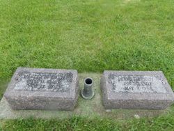
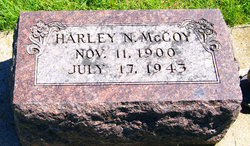
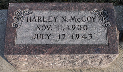
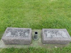
Harley Negley McCoy
| Birth | : | 11 Nov 1900 Montgomery County, Iowa, USA |
| Death | : | 17 Jul 1943 Page County, Iowa, USA |
| Burial | : | Confidence Cemetery, Georgetown, Brown County, USA |
| Coordinate | : | 38.8852997, -83.9000015 |
| Description | : | Clarinda Herald Journal (Clarinda, Iowa), Monday, July 19, 1943, [p. 1] Suicide Victim Harley McCoy Takes Life With Shotgun on Sunday Despondency was blamed in the suicide death of Harley McCoy, about 42, at his farm home north of Essex Sunday morning, according to Sheriff Ed Hipsley. Officers were called to the McCoy farm Saturday afternoon when McCoy disappeared. His car was gone and he was known to be armed, but he was not found. Officers returned to the farm Sunday morning and found McCoy’s body in a field about a mile and a quarter from the farmhouse. McCoy had apparently used a shotgun... Read More |
frequently asked questions (FAQ):
-
Where is Harley Negley McCoy's memorial?
Harley Negley McCoy's memorial is located at: Confidence Cemetery, Georgetown, Brown County, USA.
-
When did Harley Negley McCoy death?
Harley Negley McCoy death on 17 Jul 1943 in Page County, Iowa, USA
-
Where are the coordinates of the Harley Negley McCoy's memorial?
Latitude: 38.8852997
Longitude: -83.9000015
Family Members:
Parent
Spouse
Siblings
Children
Flowers:
Nearby Cemetories:
1. Confidence Cemetery
Georgetown, Brown County, USA
Coordinate: 38.8852997, -83.9000015
2. Jacobs Family Cemetery
Georgetown, Brown County, USA
Coordinate: 38.8988753, -83.9182039
3. Infirmary Cemetery
Georgetown, Brown County, USA
Coordinate: 38.8759410, -83.9224280
4. McFaddin Cemetery
Georgetown, Brown County, USA
Coordinate: 38.8819008, -83.8735962
5. Old Georgetown Cemetery
Georgetown, Brown County, USA
Coordinate: 38.8642006, -83.9096985
6. Berry Family Cemetery
Pleasant Township, Brown County, USA
Coordinate: 38.9047000, -83.9218000
7. Jennings Family Cemetery
Georgetown, Brown County, USA
Coordinate: 38.8641982, -83.8689216
8. Rachford Cemetery
Wahlsburg, Brown County, USA
Coordinate: 38.9178000, -83.9204900
9. Pickering Cemetery
Georgetown, Brown County, USA
Coordinate: 38.9172390, -83.9239670
10. West Fork Cemetery
Franklin Township, Brown County, USA
Coordinate: 38.9105988, -83.8578033
11. Dye Cemetery
Brown County, USA
Coordinate: 38.8586006, -83.8516998
12. Barngrover Family Cemetery
Wahlsburg, Brown County, USA
Coordinate: 38.9317390, -83.9115140
13. Eden Cemetery
Feesburg, Brown County, USA
Coordinate: 38.8683014, -83.9589005
14. McCall Cemetery
Scott Township, Brown County, USA
Coordinate: 38.9325760, -83.9171320
15. Farmers Chapel Cemetery
Scott Township, Brown County, USA
Coordinate: 38.9247820, -83.9377760
16. Abbott Burying Ground
Arnheim, Brown County, USA
Coordinate: 38.8944360, -83.8361210
17. Wardlow Cemetery
Franklin Township, Brown County, USA
Coordinate: 38.8944016, -83.8358002
18. Unity Cemetery
Georgetown, Brown County, USA
Coordinate: 38.9219017, -83.9467010
19. Davidson Cemetery
Scott Township, Brown County, USA
Coordinate: 38.9360300, -83.9128290
20. Waterfield Cemetery
Georgetown, Brown County, USA
Coordinate: 38.8295756, -83.9152510
21. Hillman Ridge Cemetery
Georgetown, Brown County, USA
Coordinate: 38.8353004, -83.8621979
22. Sanders Cemetery
Hamersville, Brown County, USA
Coordinate: 38.9367020, -83.9352320
23. Rich Family Cemetery
Hamersville, Brown County, USA
Coordinate: 38.9207517, -83.9606343
24. Bohrer Cemetery
Franklin Township, Brown County, USA
Coordinate: 38.9019012, -83.8257980

