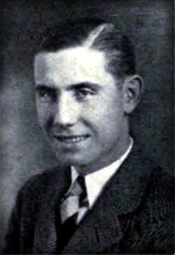
Rex Edward Ruch
| Birth | : | 21 Sep 1903 Pierson, Woodbury County, Iowa, USA |
| Death | : | 26 Jan 1988 Denison, Crawford County, Iowa, USA |
| Burial | : | Fletts Cemetery, Lower Moutere, Tasman District, New Zealand |
| Coordinate | : | -41.1715560, 172.9992190 |
| Description | : | DENISON, Iowa - Rex E. Ruch, 84, of Denison died Tuesday in a hospital in Denison of injures suffered in a traffic accident in Denison. Mr. Ruch was born Sept. 21, 1903, in Pierson. He graduated from Pierson High School and Iowa State University. He married Marjorie Raw on Oct. 5, 1929, in Pierson. The couple made their home in Denison where he was a vocational agriculture instructor and counselor in the Denison School System for 42 years. In 1935 he received a master of science degree from the University of Wisconsin. In 1941 he... Read More |
frequently asked questions (FAQ):
-
Where is Rex Edward Ruch's memorial?
Rex Edward Ruch's memorial is located at: Fletts Cemetery, Lower Moutere, Tasman District, New Zealand.
-
When did Rex Edward Ruch death?
Rex Edward Ruch death on 26 Jan 1988 in Denison, Crawford County, Iowa, USA
-
Where are the coordinates of the Rex Edward Ruch's memorial?
Latitude: -41.1715560
Longitude: 172.9992190
Family Members:
Parent
Spouse
Flowers:
Nearby Cemetories:
1. Fletts Cemetery
Lower Moutere, Tasman District, New Zealand
Coordinate: -41.1715560, 172.9992190
2. Motueka Cemetery
Motueka, Tasman District, New Zealand
Coordinate: -41.1280550, 173.0198830
3. Waiwhero Cemetery
Ngatimoti, Tasman District, New Zealand
Coordinate: -41.1879690, 172.9304540
4. Pah Street Methodist Cemetery
Motueka, Tasman District, New Zealand
Coordinate: -41.1105140, 173.0018140
5. Moutere Hills Cemetery
Upper Moutere, Tasman District, New Zealand
Coordinate: -41.2365927, 173.0102027
6. Pioneer Park
Motueka, Tasman District, New Zealand
Coordinate: -41.1059000, 173.0211850
7. Pangatotara Cemetery
Pangatotara, Tasman District, New Zealand
Coordinate: -41.1146220, 172.9456110
8. St. Paul's Lutheran Churchyard
Upper Moutere, Tasman District, New Zealand
Coordinate: -41.2703770, 173.0058870
9. Riwaka Cemetery
Riwaka, Tasman District, New Zealand
Coordinate: -41.0676130, 172.9848570
10. Dovedale Cemetery
Dovedale, Tasman District, New Zealand
Coordinate: -41.2900770, 172.8970380
11. Sandy Bay Cemetery
Sandy Bay, Tasman District, New Zealand
Coordinate: -41.0177570, 172.9775800
12. Saint Peter & Paul Catholic Churchyard
Appleby, Tasman District, New Zealand
Coordinate: -41.3172800, 173.1117800
13. Saint Alban's Appleby Churchyard
Appleby, Tasman District, New Zealand
Coordinate: -41.3173900, 173.1370900
14. Waimea West Cemetery
Brightwater, Tasman District, New Zealand
Coordinate: -41.3364880, 173.1062950
15. St Michael's Churchyard
Brightwater, Tasman District, New Zealand
Coordinate: -41.3383330, 173.1060180
16. Stanley Brook Cemetery
Stanley Brook, Tasman District, New Zealand
Coordinate: -41.3311820, 172.8206200
17. St John's Lutheran Churchyard
Hope, Tasman District, New Zealand
Coordinate: -41.3496940, 173.1488400
18. Saint Pauls Churchyard
Brightwater, Tasman District, New Zealand
Coordinate: -41.3705220, 173.1032750
19. Seaview Cemetery
Nelson, Nelson City, New Zealand
Coordinate: -41.3037350, 173.2262930
20. Haulashore Island
Nelson, Nelson City, New Zealand
Coordinate: -41.2691290, 173.2589020
21. Haven Cemetery
Nelson, Nelson City, New Zealand
Coordinate: -41.2732100, 173.2603300
22. Richmond Cemetery
Richmond, Tasman District, New Zealand
Coordinate: -41.3485780, 173.1782300
23. Spring Grove School Burials
Spring Grove, Tasman District, New Zealand
Coordinate: -41.3852900, 173.0903000
24. Pioneer Family Grave
Hope, Tasman District, New Zealand
Coordinate: -41.3589679, 173.1671130


