
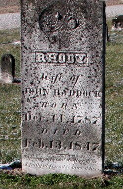
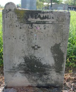
Rhody Potts Haddock
| Birth | : | 14 Dec 1787 Pennsylvania, USA |
| Death | : | 13 Feb 1847 Dubois County, Indiana, USA |
| Burial | : | St. Mary's Churchyard, Nether Stowey, Sedgemoor District, England |
| Coordinate | : | 51.1502280, -3.1494270 |
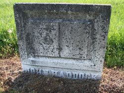
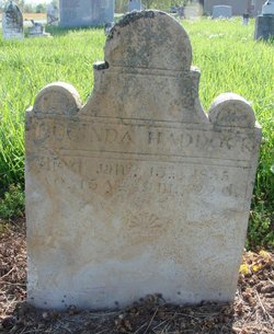
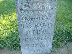
| Description | : | Wife of John Haddock. They were the parents of: 1) Downey Haddock 2) Sarah Haddock Married: Marten B. Mason 3) Susannah Haddock (B: 1809) 4) Admiral Haddock (1810-1856) 5) Whiteside S. Haddock (1811-1848) Married: Jane S. Harbison - Had 5 children 6) Elizabeth Haddock (B; 1813) 7) Blackstone Haddock (B: 1814) 8) Mary Haddock Married: Lewis Combs 9) Lucinda B. Haddock (1819-1835) 10) James Haddock (B: 1824) 11) Thomas Haddock (B: 1824) 12) Alexander Downey Haddock (B: 1825) Married: Elizabeth Sanders 13) John Haddock (B: 1825) 14) Rhoda B. Haddock (1827-1828) 15) Greenberry Haddock (1831-1851) SOURCE: http://trees.ancestry.com/tree/17789250/ person/555971594 |
frequently asked questions (FAQ):
-
Where is Rhody Potts Haddock's memorial?
Rhody Potts Haddock's memorial is located at: St. Mary's Churchyard, Nether Stowey, Sedgemoor District, England.
-
When did Rhody Potts Haddock death?
Rhody Potts Haddock death on 13 Feb 1847 in Dubois County, Indiana, USA
-
Where are the coordinates of the Rhody Potts Haddock's memorial?
Latitude: 51.1502280
Longitude: -3.1494270
Family Members:
Spouse
Children


Flowers:


Nearby Cemetories:
1. St. Mary's Churchyard
Nether Stowey, Sedgemoor District, England
Coordinate: 51.1502280, -3.1494270
2. Nether Stowey Cemetery
Nether Stowey, Sedgemoor District, England
Coordinate: 51.1498667, -3.1530087
3. Over Stowey Cemetery
Over Stowey, Sedgemoor District, England
Coordinate: 51.1404020, -3.1661850
4. St Peter and St Paul Churchyard
Over Stowey, Sedgemoor District, England
Coordinate: 51.1399680, -3.1656040
5. St. Martin's Churchyard
Fiddington, Sedgemoor District, England
Coordinate: 51.1591640, -3.1229530
6. All Saints Churchyard
Dodington, West Somerset District, England
Coordinate: 51.1583770, -3.1854620
7. Stogursey Extension Cemetery
Stogursey, West Somerset District, England
Coordinate: 51.1793740, -3.1398040
8. St Andrew Churchyard
Stogursey, West Somerset District, England
Coordinate: 51.1795900, -3.1392800
9. St. Mary's Churchyard
Stringston, West Somerset District, England
Coordinate: 51.1748960, -3.1795460
10. Saint Margaret's Churchyard
Spaxton, Sedgemoor District, England
Coordinate: 51.1273090, -3.1087000
11. Spaxton Extension Cemetery
Spaxton, Sedgemoor District, England
Coordinate: 51.1267650, -3.1082920
12. All Saints Churchyard
Aisholt, Sedgemoor District, England
Coordinate: 51.1142070, -3.1532890
13. St. Mary's Churchyard
Holford, West Somerset District, England
Coordinate: 51.1627900, -3.2074238
14. Burton Baptist Chapel
Stogursey, West Somerset District, England
Coordinate: 51.1910560, -3.1560340
15. Charlynch Church of Saint Mary
Spaxton, Sedgemoor District, England
Coordinate: 51.1342600, -3.0879100
16. St. Nicholas's Churchyard
Holford, West Somerset District, England
Coordinate: 51.1902700, -3.1949170
17. Cannington Cemetery
Cannington, Sedgemoor District, England
Coordinate: 51.1500620, -3.0697070
18. St.Mary Magdalene
Stockland Bristol, Sedgemoor District, England
Coordinate: 51.1867260, -3.0886950
19. St. Andrew's Churchyard
Lilstock, West Somerset District, England
Coordinate: 51.1971070, -3.1936420
20. All Saints Churchyard
Otterhampton, Sedgemoor District, England
Coordinate: 51.1829540, -3.0796420
21. Blessed Virgin Mary Churchyard
Cannington, Sedgemoor District, England
Coordinate: 51.1500970, -3.0622850
22. Otterhampton Extension Cemetery
Otterhampton, Sedgemoor District, England
Coordinate: 51.1828490, -3.0791630
23. St. Michael's Churchyard
Enmore, Sedgemoor District, England
Coordinate: 51.1110830, -3.0872790
24. Holy Ghost Churchyard
Crowcombe, West Somerset District, England
Coordinate: 51.1232260, -3.2293260