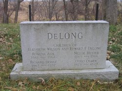
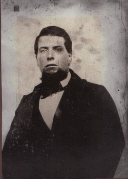
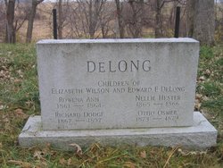
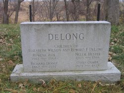
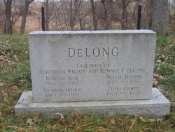
Richard Dodge DeLong
| Birth | : | 29 Aug 1867 Mahaska County, Iowa, USA |
| Death | : | 18 Dec 1897 |
| Burial | : | Matarawa Presbyterian Cemetery, Whanganui, Whanganui District, New Zealand |
| Coordinate | : | -39.9461300, 175.1433100 |
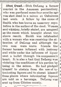
| Description | : | Son of Edward and Elizabeth DeLong Following Info provided by Carla #47658428 THE DAILY EVENING HERALD, MONDAY, DECEMBER 20, 1897 - OSKALOOSA, MAHASKA COUNTY, IOWA DICK DELONG KILLED Either shot Accidentally or Deliberately Murdered by Norman Smith The Shooting Took Place in Beadle's Saloon Saturday Night-Death Ensued Sunday Dick Delong was fatally shot by Norman Smith, Saturday evening, shortly before six o'clock, in Chas. Beadle's saloon. The bullet from a 33 revolver entered the left side at about the short ribs. Delong died Sunday afternoon. Smith was arrested Saturday night and put under $3,000.00 (this may be $8,000.00 - hard to read... Read More |
frequently asked questions (FAQ):
-
Where is Richard Dodge DeLong's memorial?
Richard Dodge DeLong's memorial is located at: Matarawa Presbyterian Cemetery, Whanganui, Whanganui District, New Zealand.
-
When did Richard Dodge DeLong death?
Richard Dodge DeLong death on 18 Dec 1897 in
-
Where are the coordinates of the Richard Dodge DeLong's memorial?
Latitude: -39.9461300
Longitude: 175.1433100
Family Members:
Parent
Siblings
Flowers:
Nearby Cemetories:
1. Matarawa Presbyterian Cemetery
Whanganui, Whanganui District, New Zealand
Coordinate: -39.9461300, 175.1433100
2. Matarawa Cemetery
Fordell, Whanganui District, New Zealand
Coordinate: -39.9468100, 175.1452700
3. Aramoho Cemetery
Whanganui, Whanganui District, New Zealand
Coordinate: -39.8926494, 175.0922441
4. Putiki Urupā
Whanganui District, New Zealand
Coordinate: -39.9466140, 175.0499350
5. Heads Road Cemetery
Whanganui, Whanganui District, New Zealand
Coordinate: -39.9393300, 175.0473400
6. St. Mary's Anglican Church Cemetery
Upokongaro, Whanganui District, New Zealand
Coordinate: -39.8656100, 175.1132820
7. Ratana Cemetery
Ratana, Rangitikei District, New Zealand
Coordinate: -40.0311470, 175.1771200
8. Kauangaroa Pa Cemetery
Kauangaroa, Whanganui District, New Zealand
Coordinate: -39.9231800, 175.2788000
9. Turakina Cemetery
Turakina, Rangitikei District, New Zealand
Coordinate: -40.0461300, 175.2140160
10. Turakina Catholic Cemetery
Turakina, Rangitikei District, New Zealand
Coordinate: -40.0453000, 175.2239600
11. Te Mangungu Churchyard
Turakina, Rangitikei District, New Zealand
Coordinate: -40.0633110, 175.1818200
12. Grant Family Makirikiri Cemetery
Turakina, Rangitikei District, New Zealand
Coordinate: -40.0625400, 175.2258200
13. Brunswick Cemetery
Brunswick, Whanganui District, New Zealand
Coordinate: -39.8417750, 175.0216400
14. Bonny Glen Cemetery
Marton, Rangitikei District, New Zealand
Coordinate: -40.0496200, 175.3410200
15. Papanui Urupā
Kai Iwi, Whanganui District, New Zealand
Coordinate: -39.8435190, 174.9216230
16. Upper Tutaenui Cemetery
Marton, Rangitikei District, New Zealand
Coordinate: -40.0086900, 175.4093900
17. Marton Lutheran Cemetery Tutaenui
Marton, Rangitikei District, New Zealand
Coordinate: -40.0772400, 175.3692700
18. St Stephens Anglican Cemetery
Marton, Rangitikei District, New Zealand
Coordinate: -40.0618230, 175.4258020
19. Mount View Cemetery
Marton, Rangitikei District, New Zealand
Coordinate: -40.0631570, 175.4252250
20. Maxwell Cemetery
Whanganui, Whanganui District, New Zealand
Coordinate: -39.8224020, 174.8530960
21. Pakaraka Māori Cemetery
Maxwell, Whanganui District, New Zealand
Coordinate: -39.8226300, 174.8460700
22. St John's Anglican Church Cemetery
Marton, Rangitikei District, New Zealand
Coordinate: -40.0298860, 175.4759430
23. Marshall Family Cemetery
Matahiwi, Whanganui District, New Zealand
Coordinate: -39.6757200, 175.1595964
24. Greatford Cemetery
Greatford, Rangitikei District, New Zealand
Coordinate: -40.1260100, 175.4175700

