
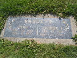
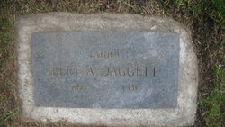
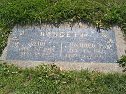
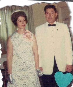
Richard Percival “Rich” Daggett
| Birth | : | 12 Feb 1916 Sheridan, Sheridan County, Wyoming, USA |
| Death | : | 24 May 2003 Quincy, Grant County, Washington, USA |
| Burial | : | Smith-Morse Cemetery, Sandwich, Carroll County, USA |
| Coordinate | : | 43.7768000, -71.4301000 |
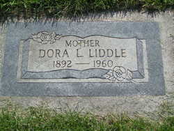
| Description | : | Rich Daggett, 87, of Quincy passed away Saturday, May 24th, 2003, at Central Washington Hospital. He was born at Sheridan, Wyoming, on February 12th, 1916, to Bert and Dora (Osieck) Daggett. He served in the U.S. Navy in World War II. He worked for Atwells for 20 years, making ceiling beams that are in many buildings around the state of Washington. He also farmed for over 30 years until retiring 2 years ago. He loved going to Wenatchee where he had lived for many years and visiting with his relatives and friends there. He married his first wife, Rena Wheeler,... Read More |
frequently asked questions (FAQ):
-
Where is Richard Percival “Rich” Daggett's memorial?
Richard Percival “Rich” Daggett's memorial is located at: Smith-Morse Cemetery, Sandwich, Carroll County, USA.
-
When did Richard Percival “Rich” Daggett death?
Richard Percival “Rich” Daggett death on 24 May 2003 in Quincy, Grant County, Washington, USA
-
Where are the coordinates of the Richard Percival “Rich” Daggett's memorial?
Latitude: 43.7768000
Longitude: -71.4301000
Family Members:
Parent
Spouse
Siblings
Children

Flowers:


Nearby Cemetories:
1. Smith-Morse Cemetery
Sandwich, Carroll County, USA
Coordinate: 43.7768000, -71.4301000
2. Moulton-Beede Cemetery
Sandwich, Carroll County, USA
Coordinate: 43.7774000, -71.4276000
3. Haines Cemetery
Union, Carroll County, USA
Coordinate: 43.7734000, -71.4331000
4. Mason Cemetery
Center Sandwich, Carroll County, USA
Coordinate: 43.7858000, -71.4258000
5. Mason Cemetery
Moultonborough, Carroll County, USA
Coordinate: 43.7574500, -71.4184000
6. Cemetery of the Religious Society of Friends
Sandwich, Carroll County, USA
Coordinate: 43.7994400, -71.4266700
7. Littles Pond Cemetery
Sandwich, Carroll County, USA
Coordinate: 43.7915600, -71.4034200
8. Freese Cemetery
Moultonborough, Carroll County, USA
Coordinate: 43.7616670, -71.4008330
9. Beede Cemetery
Sandwich, Carroll County, USA
Coordinate: 43.8013890, -71.4166670
10. Holland Hill Cemetery
Moultonborough, Carroll County, USA
Coordinate: 43.7620300, -71.3995400
11. Baptist Burial Ground
Center Sandwich, Carroll County, USA
Coordinate: 43.8079900, -71.4392600
12. Richard Fry Cemetery
Sandwich, Carroll County, USA
Coordinate: 43.7822817, -71.3830099
13. Nathanial Fry Family Plot
Sandwich, Carroll County, USA
Coordinate: 43.7875872, -71.3844592
14. Grove Cemetery
Sandwich, Carroll County, USA
Coordinate: 43.8101100, -71.4445200
15. Rollins Cemetery
Moultonborough, Carroll County, USA
Coordinate: 43.7430420, -71.4106610
16. Mears-Nelson Cemetery
Sandwich, Carroll County, USA
Coordinate: 43.7932790, -71.3820560
17. Clement Cemetery
Moultonborough, Carroll County, USA
Coordinate: 43.7586110, -71.3827780
18. Elm Hill Cemetery
Center Sandwich, Carroll County, USA
Coordinate: 43.8158000, -71.4336000
19. Elm Hill Cemetery
Sandwich, Carroll County, USA
Coordinate: 43.8158330, -71.4338890
20. Cook Family Cemetery
Moultonborough, Carroll County, USA
Coordinate: 43.7435585, -71.4621048
21. Chicks Corner Cemetery
Sandwich, Carroll County, USA
Coordinate: 43.8041000, -71.4728900
22. Rogers Cemetery
Moultonborough, Carroll County, USA
Coordinate: 43.7707400, -71.3693100
23. Brown Cemetery
Moultonborough, Carroll County, USA
Coordinate: 43.7476220, -71.3815960
24. Lee Cemetery
Moultonborough, Carroll County, USA
Coordinate: 43.7472230, -71.3812320