
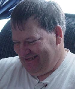
Robert “Bob” Austad
| Birth | : | 26 Dec 1951 Sioux Falls, Minnehaha County, South Dakota, USA |
| Death | : | 15 Aug 2015 Mobridge, Walworth County, South Dakota, USA |
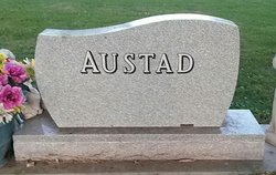
| Burial | : | Scotty Philip Cemetery, Fort Pierre, Stanley County, USA |
| Coordinate | : | 44.4019012, -100.4036026 |
| Plot | : | Section 1 Lot 121 Grave 1 |
| Description | : | Robert "Bob" Austad (December 26, 1951 - August 15, 2015) Robert “Bob” Austad, 63 of Pierre, died Saturday, August 15 at Mobridge Regional Hospital. Visitation will be 5-7pm, Thursday, August 20 at Isburg Funeral Chapel with Prayer Service at 7:00pm. Services will be at 1:30pm, Friday, August 21 at Isburg Funeral Chapel with burial at Scotty Philip Cemetery. You are welcome to join the family for fellowship following the services at the community room of Missouri View apartments (2511 E Irwin). Bob was born on December 26, 1951 to Stanley and Irene (Thompson) Austad in Sioux... Read More |
frequently asked questions (FAQ):
-
Where is Robert “Bob” Austad's memorial?
Robert “Bob” Austad's memorial is located at: Scotty Philip Cemetery, Fort Pierre, Stanley County, USA.
-
When did Robert “Bob” Austad death?
Robert “Bob” Austad death on 15 Aug 2015 in Mobridge, Walworth County, South Dakota, USA
-
Where are the coordinates of the Robert “Bob” Austad's memorial?
Latitude: 44.4019012
Longitude: -100.4036026
Family Members:
Parent

Siblings
Flowers:


Nearby Cemetories:
1. Scotty Philip Cemetery
Fort Pierre, Stanley County, USA
Coordinate: 44.4019012, -100.4036026
2. Fort Pierre Chouteau Cemetery
Fort Pierre, Stanley County, USA
Coordinate: 44.3908700, -100.3878300
3. Mount Calvary Cemetery
Pierre, Hughes County, USA
Coordinate: 44.4197006, -100.3557968
4. South Dakota State Capitol Grounds
Pierre, Hughes County, USA
Coordinate: 44.3660100, -100.3448000
5. Cedar Hill Cemetery
Fort Pierre, Stanley County, USA
Coordinate: 44.3356018, -100.3964005
6. Riverside Cemetery
Pierre, Hughes County, USA
Coordinate: 44.3608017, -100.3071976
7. Byron Township Cemetery
Blunt, Hughes County, USA
Coordinate: 44.4979200, -100.1904700
8. Fort Sully Post Cemetery
Sully County, USA
Coordinate: 44.5866480, -100.6087530
9. Meers Cemetery
Stanley County, USA
Coordinate: 44.4116970, -100.7360760
10. Mathews Family Cemetery
Stanley County, USA
Coordinate: 44.1816040, -100.5581080
11. Okobojo Cemetery
Sully County, USA
Coordinate: 44.6568985, -100.3647003
12. Canning Cemetery
Hughes County, USA
Coordinate: 44.3986890, -100.0278460
13. Holy Name Episcopal Cemetery
Fort Pierre, Stanley County, USA
Coordinate: 44.2694960, -100.0357300
14. Holy Name Chapel Cemetery
Fort Pierre, Stanley County, USA
Coordinate: 44.2694292, -100.0356989
15. Pleasant Hill Cemetery
Blunt, Hughes County, USA
Coordinate: 44.5135994, -100.0156021
16. Fort Bennett Post Cemetery
Stanley County, USA
Coordinate: 44.6716500, -100.6404200
17. Immanuel Lutheran Cemetery
Van Metre, Jones County, USA
Coordinate: 44.0958800, -100.7263300
18. Mission Ridge Cemetery
Mission Ridge, Stanley County, USA
Coordinate: 44.6960983, -100.7716980
19. Onida Cemetery
Onida, Sully County, USA
Coordinate: 44.7147000, -100.0650000
20. Chapelle Cemetery
Hughes County, USA
Coordinate: 44.3025017, -99.8653030
21. Holy Faith Cemetery
Lyman County, USA
Coordinate: 44.1356010, -99.9878006
22. Blair Cemetery
Sully County, USA
Coordinate: 44.8027992, -100.4199982
23. Sansarc Cemetery
Hayes, Stanley County, USA
Coordinate: 44.5153008, -101.0342026
24. Draper Cemetery
Draper, Jones County, USA
Coordinate: 43.9322014, -100.5475006