
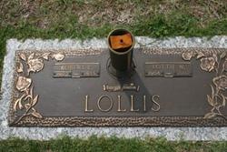
Robert Clifton Lollis
| Birth | : | 20 Aug 1907 Greenville County, South Carolina, USA |
| Death | : | 19 Jul 1955 Greenville County, South Carolina, USA |
| Burial | : | Kent and Sussex Cemetery and Crematorium, Royal Tunbridge Wells, Tunbridge Wells Borough, England |
| Coordinate | : | 51.1173720, 0.2740330 |
| Description | : | FORK SHOALS July-20. Funeral services for Robert Clifton Lollis, 47, who died last night will beconducted Thursday at 5 p.m.at Fork Shoals Baptist Church by the Rev.C.R.White, the Rev.Roy Julian and Rev.Eugene Carroll. burial will be in Cannon Memorial Park. Pallbeaers will be Nephews.Honerery escort will be Marvin Meeks, A.E.Rogers, Will Henderson, Wallace Hipps, Mr.Chasteen, Y.B. Kellett, Bill Rogers,Clyde Jenkins, Mabe Harvey, Roy King, Harry Peden, Jim Coker, Clarence Williams, Broadus Maddison and John Sullivan. the body is at the home, Cannon Funeral Home,Fountain Inn is in charge. |
frequently asked questions (FAQ):
-
Where is Robert Clifton Lollis's memorial?
Robert Clifton Lollis's memorial is located at: Kent and Sussex Cemetery and Crematorium, Royal Tunbridge Wells, Tunbridge Wells Borough, England.
-
When did Robert Clifton Lollis death?
Robert Clifton Lollis death on 19 Jul 1955 in Greenville County, South Carolina, USA
-
Where are the coordinates of the Robert Clifton Lollis's memorial?
Latitude: 51.1173720
Longitude: 0.2740330
Family Members:
Spouse

Children

Flowers:


Nearby Cemetories:
1. Kent and Sussex Cemetery and Crematorium
Royal Tunbridge Wells, Tunbridge Wells Borough, England
Coordinate: 51.1173720, 0.2740330
2. Trinity Churchyard
Royal Tunbridge Wells, Tunbridge Wells Borough, England
Coordinate: 51.1328200, 0.2623600
3. St. Alban's Churchyard
Frant, Wealden District, England
Coordinate: 51.0980580, 0.2698300
4. Hanover Strict Baptist Chapel
Royal Tunbridge Wells, Tunbridge Wells Borough, England
Coordinate: 51.1356700, 0.2625100
5. Woodbury Park Cemetery
Royal Tunbridge Wells, Tunbridge Wells Borough, England
Coordinate: 51.1389847, 0.2637900
6. St John's Church
Royal Tunbridge Wells, Tunbridge Wells Borough, England
Coordinate: 51.1402330, 0.2608070
7. St. Paul's Churchyard
Rusthall, Tunbridge Wells Borough, England
Coordinate: 51.1307144, 0.2376710
8. Holy Trinity Churchyard
Eridge Green, Wealden District, England
Coordinate: 51.0989300, 0.2232190
9. Pembury Burial Ground
Pembury, Tunbridge Wells Borough, England
Coordinate: 51.1416270, 0.3229290
10. St Paul New Churchyard
Rusthall, Tunbridge Wells Borough, England
Coordinate: 51.1401520, 0.2204420
11. Southborough Cemetery
Southborough, Tunbridge Wells Borough, England
Coordinate: 51.1592860, 0.2420140
12. St Peter's New Churchyard
Pembury, Tunbridge Wells Borough, England
Coordinate: 51.1506200, 0.3269600
13. All Saints Churchyard
Langton Green, Tunbridge Wells Borough, England
Coordinate: 51.1309738, 0.2022060
14. St. Peter's Churchyard
Southborough, Tunbridge Wells Borough, England
Coordinate: 51.1626549, 0.2520690
15. St. Mary the Virgin Churchyard
Speldhurst, Tunbridge Wells Borough, England
Coordinate: 51.1510790, 0.2198230
16. Southborough War Memorial
Southborough, Tunbridge Wells Borough, England
Coordinate: 51.1639214, 0.2528920
17. Bayham Old Abbey
Lamberhurst, Tunbridge Wells Borough, England
Coordinate: 51.1032690, 0.3541800
18. St. Lawrence Churchyard
Bidborough, Tunbridge Wells Borough, England
Coordinate: 51.1666950, 0.2371870
19. Old Churchyard of St Peter
Pembury, Tunbridge Wells Borough, England
Coordinate: 51.1629330, 0.3241620
20. St John the Evangelist Churchyard
Groombridge, Wealden District, England
Coordinate: 51.1179771, 0.1854370
21. St. Luke's Churchyard
Matfield, Tunbridge Wells Borough, England
Coordinate: 51.1426588, 0.3626785
22. All Souls Churchyard
Poundsbridge, Sevenoaks District, England
Coordinate: 51.1540700, 0.1961470
23. St. Peter's Churchyard
Fordcombe, Sevenoaks District, England
Coordinate: 51.1422043, 0.1792730
24. St. Peter & St. Paul Churchyard
Wadhurst, Wealden District, England
Coordinate: 51.0626960, 0.3400690