


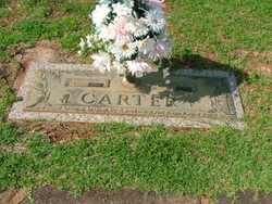
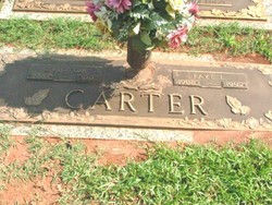
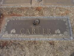
Robert Daniel “Nick” Carter
| Birth | : | 12 Sep 1915 Jonesville, Union County, South Carolina, USA |
| Death | : | 24 Jul 1993 Walhalla, Oconee County, South Carolina, USA |
| Burial | : | Manly Cemetery, Manly, Northern Beaches Council, Australia |
| Coordinate | : | -33.7922700, 151.2715000 |
| Plot | : | Section E, Lot 437, Space 2. |
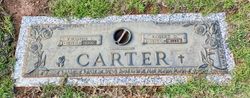
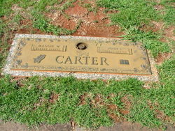
| Description | : | Son of, the late John Shelton Carter Sr. and Margaret Louise "Maggie" White- Carter. Grandson of, the late John Franklin and Frances Sparks- Carter. Husband of, the late Virginia Mildred "Jenny" Lee- Carter. Son-In-Law to, William Samuel "Sam" and Carrie Elizabeth Friddle- Lee Jr. Step-Father to, Ralph W. Lee. Step-Father-In-Law to, the late Bettye J. Lee (wife of Ralph W. Lee). Grandfather to, Elizabeth A. "Beth" Lee- Moore- Schofield and David J. Lee. Grandfather-In-Law to, Arthur R. "Art" Schofield. Former Grandfather-In-Law to, Gregory J. "Greg" Moore. Great Grandfather to, Brady L. Moore, Brandon A. and Sean M. Schofield. All... Read More |
frequently asked questions (FAQ):
-
Where is Robert Daniel “Nick” Carter's memorial?
Robert Daniel “Nick” Carter's memorial is located at: Manly Cemetery, Manly, Northern Beaches Council, Australia.
-
When did Robert Daniel “Nick” Carter death?
Robert Daniel “Nick” Carter death on 24 Jul 1993 in Walhalla, Oconee County, South Carolina, USA
-
Where are the coordinates of the Robert Daniel “Nick” Carter's memorial?
Latitude: -33.7922700
Longitude: 151.2715000
Family Members:
Parent
Spouse
Siblings

Children
Flowers:


Nearby Cemetories:
1. Sydney North Head Quarantine Cemetery
Manly, Northern Beaches Council, Australia
Coordinate: -33.8177130, 151.2947000
2. Rawson Park
Mosman, Mosman Municipality, Australia
Coordinate: -33.8350640, 151.2504980
3. St. Thomas Rest Park
Crows Nest, North Sydney Council, Australia
Coordinate: -33.8244490, 151.2063050
4. Mary MacKillop Memorial Chapel
North Sydney, North Sydney Council, Australia
Coordinate: -33.8388250, 151.2049160
5. Gore Hill Cemetery
St Leonards, North Sydney Council, Australia
Coordinate: -33.8229500, 151.1887590
6. Garden Island
Potts Point, City of Sydney, Australia
Coordinate: -33.8613635, 151.2280308
7. Frenchs Forest Cemetery
Davidson, Northern Beaches Council, Australia
Coordinate: -33.7392360, 151.2020750
8. Royal Botanic Gardens
Sydney, City of Sydney, Australia
Coordinate: -33.8647440, 151.2170610
9. St Aidan's Anglican Church
Longueville, Lane Cove Municipality, Australia
Coordinate: -33.8281510, 151.1709560
10. Parish Church of Saint James
Sydney, City of Sydney, Australia
Coordinate: -33.8693760, 151.2111540
11. Saint Mary's Cathedral
Sydney, City of Sydney, Australia
Coordinate: -33.8708540, 151.2135820
12. Old Sydney Burial Ground
Sydney, City of Sydney, Australia
Coordinate: -33.8731750, 151.2063850
13. Northern Suburbs Memorial Gardens and Crematorium
North Ryde, Ryde City, Australia
Coordinate: -33.7954460, 151.1511550
14. Devonshire Street Cemetery (Defunct)
Sydney, City of Sydney, Australia
Coordinate: -33.8828080, 151.2066180
15. St. John's Anglican Church Cemetery
Gordon, Ku-ring-gai Council, Australia
Coordinate: -33.7571060, 151.1519580
16. Church of St. Francis and St. Alban
Gordon, Ku-ring-gai Council, Australia
Coordinate: -33.7563700, 151.1522220
17. Macquarie Park Cemetery and Crematorium
North Ryde, Ryde City, Australia
Coordinate: -33.7937180, 151.1420060
18. Mona Vale Cemetery
Mona Vale, Northern Beaches Council, Australia
Coordinate: -33.6752140, 151.2879720
19. Mona Vale Anglican Church
Mona Vale, Northern Beaches Council, Australia
Coordinate: -33.6745924, 151.3031547
20. Saint Jude's Cemetery
Randwick, Randwick City, Australia
Coordinate: -33.9115460, 151.2417130
21. Gladesville Asylum Cemetery
Gladesville, Hunter's Hill Municipality, Australia
Coordinate: -33.8393010, 151.1342490
22. Field of Mars Cemetery
East Ryde, Ryde City, Australia
Coordinate: -33.8120030, 151.1246480
23. Camperdown Cemetery
Newtown, City of Sydney, Australia
Coordinate: -33.8942220, 151.1804900
24. Pioneers Memorial Park
Leichhardt, Inner West Council, Australia
Coordinate: -33.8780800, 151.1575000