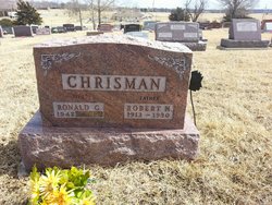
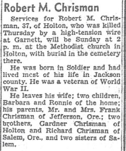
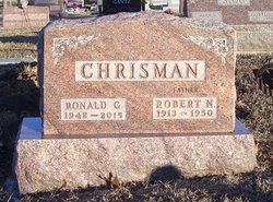
Robert Norris Chrisman
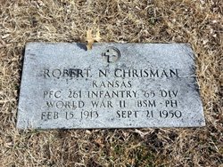
| Birth | : | 15 Feb 1913 Soldier, Jackson County, Kansas, USA |
| Death | : | 21 Sep 1950 Holton, Jackson County, Kansas, USA |
| Burial | : | Republic Cemetery, Republic, Ferry County, USA |
| Coordinate | : | 48.6555363, -118.7218022 |
| Plot | : | Section K |
| Inscription | : | Kansas PFC 261 Infantry 65 Div World War II 85M - PH |
| Description | : | son of Charles Frank and Ferne Fay (Fairbanks) Chrisman graduated from Soldier (KS) High School in 1933 |
frequently asked questions (FAQ):
-
Where is Robert Norris Chrisman's memorial?
Robert Norris Chrisman's memorial is located at: Republic Cemetery, Republic, Ferry County, USA.
-
When did Robert Norris Chrisman death?
Robert Norris Chrisman death on 21 Sep 1950 in Holton, Jackson County, Kansas, USA
-
Where are the coordinates of the Robert Norris Chrisman's memorial?
Latitude: 48.6555363
Longitude: -118.7218022
Family Members:
Parent
Spouse
Siblings
Children
Flowers:
Nearby Cemetories:
1. Republic Cemetery
Republic, Ferry County, USA
Coordinate: 48.6555363, -118.7218022
2. Somday Family Cemetery
Malo, Ferry County, USA
Coordinate: 48.8290000, -118.5990000
3. West Fork Cemetery
Ferry County, USA
Coordinate: 48.4627511, -118.7548142
4. Thomason Ranch Graves
Okanogan County, USA
Coordinate: 48.7757200, -118.9821900
5. Curlew City Cemetery
Curlew, Ferry County, USA
Coordinate: 48.8734163, -118.6010599
6. Aeneas Valley Cemetery
Okanogan County, USA
Coordinate: 48.5751200, -119.0513500
7. Merritt Pioneer Grave
Curlew, Ferry County, USA
Coordinate: 48.8745300, -118.6020000
8. Wauconda Cemetery
Wauconda, Okanogan County, USA
Coordinate: 48.7408300, -119.0597300
9. Curlew Indian Cemetery
Curlew, Ferry County, USA
Coordinate: 48.8811145, -118.6002982
10. Eagle Cliff Cemetery
Toroda, Ferry County, USA
Coordinate: 48.9404375, -118.7946296
11. Ranald McDonald Cemetery
Toroda, Ferry County, USA
Coordinate: 48.9472094, -118.7617135
12. Chesaw Cemetery
Okanogan County, USA
Coordinate: 48.9299900, -119.0541800
13. Village of Midway Cemetery
Midway, Kootenay Boundary Regional District, Canada
Coordinate: 49.0082520, -118.7609490
14. Danville Cemetery
Ferry County, USA
Coordinate: 48.9885640, -118.5151702
15. Thorp Cemetery
Chesaw, Okanogan County, USA
Coordinate: 48.9549900, -119.0316700
16. Immanuel Lutheran Cemetery
Havillah, Okanogan County, USA
Coordinate: 48.8305500, -119.2033500
17. Anglin Cemetery
Okanogan County, USA
Coordinate: 48.6627700, -119.2783400
18. Garden Valley Cemetery
Ferry County, USA
Coordinate: 48.5230560, -118.1891670
19. Kipling Cemetery
Okanogan County, USA
Coordinate: 48.9080500, -119.1652900
20. USCC Sion Cemetery
Grand Forks, Kootenay Boundary Regional District, Canada
Coordinate: 49.0159500, -118.4964300
21. Orient Cemetery
Orient, Ferry County, USA
Coordinate: 48.8578987, -118.2032013
22. Barnaby Mission Cemetery (Defunct)
Inchelium, Ferry County, USA
Coordinate: 48.4328800, -118.2202500
23. Phillip Raux Gravesite
Riverside, Okanogan County, USA
Coordinate: 48.6271800, -119.3308500
24. Green Mountain Cemetery
Stevens County, USA
Coordinate: 48.7200180, -118.1178760

