
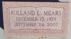
Rolland L. Mears
| Birth | : | 14 Dec 1928 McPherson, McPherson County, Kansas, USA |
| Death | : | 24 Sep 2007 Oklahoma City, Oklahoma County, Oklahoma, USA |
| Burial | : | Mount Calvary Catholic Cemetery, Lawrence, Douglas County, USA |
| Coordinate | : | 38.9580002, -95.2139969 |
| Description | : | ********************** El Dorado, KS - September 24, 2007 Rolland L. Mears, 78, died Monday September 24, 2007 at Baptist Memorial Hospital in Oklahoma City, Oklahoma. Rolland was born December 15 1928 in McPherson Kansas, son of H. Lee and Maudie "Jean" (Rodifer) Mears. He graduated from El Dorado High School and attended Emporia State University. He served in the United States Army during the Korean War. He loved to read and take photos. Surviving family include two sons Thomas L. of Minnesota, and John L. of Emporia, KS; one brother Galen Mears of El Dorado, KS; and eight grandchildren. He was preceded... Read More |
frequently asked questions (FAQ):
-
Where is Rolland L. Mears's memorial?
Rolland L. Mears's memorial is located at: Mount Calvary Catholic Cemetery, Lawrence, Douglas County, USA.
-
When did Rolland L. Mears death?
Rolland L. Mears death on 24 Sep 2007 in Oklahoma City, Oklahoma County, Oklahoma, USA
-
Where are the coordinates of the Rolland L. Mears's memorial?
Latitude: 38.9580002
Longitude: -95.2139969
Family Members:
Parent

Spouse

Siblings
Children
Flowers:


Nearby Cemetories:
1. Mount Calvary Catholic Cemetery
Lawrence, Douglas County, USA
Coordinate: 38.9580002, -95.2139969
2. Oak Hill Cemetery
Lawrence, Douglas County, USA
Coordinate: 38.9589005, -95.2118988
3. Memorial Park Cemetery
Lawrence, Douglas County, USA
Coordinate: 38.9552994, -95.2153015
4. Trinity Episcopal Church Columbarium
Lawrence, Douglas County, USA
Coordinate: 38.9653893, -95.2373886
5. Saint Johns Catholic Cemetery
Douglas County, USA
Coordinate: 38.9437900, -95.1919600
6. Dyche Hall Natural History Museum
Lawrence, Douglas County, USA
Coordinate: 38.9584800, -95.2434800
7. Haskell Cemetery
Lawrence, Douglas County, USA
Coordinate: 38.9353790, -95.2284241
8. Franklin Cemetery
Douglas County, USA
Coordinate: 38.9437523, -95.1869431
9. Pioneer Cemetery
Lawrence, Douglas County, USA
Coordinate: 38.9528008, -95.2611008
10. First Presbyterian Church Memorial Garden
Lawrence, Douglas County, USA
Coordinate: 38.9414900, -95.2641600
11. Maple Grove Cemetery
Lawrence, Douglas County, USA
Coordinate: 39.0018997, -95.2316971
12. County Poor Farm Cemetery
Douglas County, USA
Coordinate: 38.9119400, -95.2214600
13. Adams Cemetery
Douglas County, USA
Coordinate: 38.9955400, -95.2509100
14. Kennedy Cemetery
Douglas County, USA
Coordinate: 38.9112900, -95.2269200
15. Davis Cemetery
Lawrence, Douglas County, USA
Coordinate: 38.9722500, -95.2831100
16. Blue Mound Cemetery
Lawrence, Douglas County, USA
Coordinate: 38.9046600, -95.1865400
17. Marshall Cemetery
Douglas County, USA
Coordinate: 38.9040800, -95.2446700
18. Dutton Cemetery
Douglas County, USA
Coordinate: 38.8989800, -95.2790600
19. Luckan Family Cemetery
Fall Leaf, Leavenworth County, USA
Coordinate: 38.9808500, -95.1128000
20. Cemetery Beni Israel
Eudora, Douglas County, USA
Coordinate: 38.9280128, -95.1122208
21. Lyon Family Cemetery
Lawrence, Douglas County, USA
Coordinate: 38.9877440, -95.3166530
22. Corpus Christi Catholic Church Columbarium
Lawrence, Douglas County, USA
Coordinate: 38.9572250, -95.3238450
23. Southwest City Cemetery
Eudora, Douglas County, USA
Coordinate: 38.9334800, -95.1070300
24. Richland Cemetery
Lawrence, Douglas County, USA
Coordinate: 38.8768997, -95.2630997