
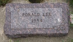
Ronald Lee TeSlaa
| Birth | : | 26 Oct 1954 Sioux Center, Sioux County, Iowa, USA |
| Death | : | 27 Oct 1954 Sioux Center, Sioux County, Iowa, USA |
| Burial | : | Costessey Parish Cemetery, Costessey, South Norfolk District, England |
| Coordinate | : | 52.6495927, 1.2040157 |
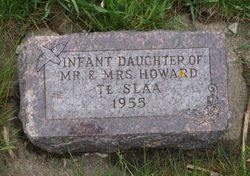
| Description | : | Ronald Lee TeSlaa, infant son of Mr. and Mrs. Howard TeSlaa of Sioux Center, died Oct. 27, a day after birth, at a Sioux Center Hospital. Besides the parents, the baby is survived by the grandparents. Mr. and Mrs. Ike Knipers of Hull and Mr. and Mrs. Gerrit II. TeSlaa of Orange City. Floyd Valley Farmers News Friday, November 12, 1954 Le Mars, Iowa ∼Obituary Mr. & Mrs. Howard Te Slaa became the parents of a son, Ronald Lee, their first child, born Tuesday of last week at the Sioux Center Hospital. The baby passed... Read More |
frequently asked questions (FAQ):
-
Where is Ronald Lee TeSlaa's memorial?
Ronald Lee TeSlaa's memorial is located at: Costessey Parish Cemetery, Costessey, South Norfolk District, England.
-
When did Ronald Lee TeSlaa death?
Ronald Lee TeSlaa death on 27 Oct 1954 in Sioux Center, Sioux County, Iowa, USA
-
Where are the coordinates of the Ronald Lee TeSlaa's memorial?
Latitude: 52.6495927
Longitude: 1.2040157
Family Members:
Parent
Siblings

Flowers:


Nearby Cemetories:
1. Costessey Parish Cemetery
Costessey, South Norfolk District, England
Coordinate: 52.6495927, 1.2040157
2. Our Lady & St. Walstan Churchyard
Costessey, South Norfolk District, England
Coordinate: 52.6583200, 1.2119300
3. Costessey Baptist Churchyard
Costessey, South Norfolk District, England
Coordinate: 52.6600122, 1.2116993
4. St Michael's Church
Bowthorpe, City of Norwich, England
Coordinate: 52.6359300, 1.2163600
5. St. Edmund's Churchyard
Costessey, South Norfolk District, England
Coordinate: 52.6660400, 1.2183410
6. St. Mary and St. Walstan Churchyard
Bawburgh, South Norfolk District, England
Coordinate: 52.6327480, 1.1796530
7. Colney Woodland Burial Park
Colney, South Norfolk District, England
Coordinate: 52.6254580, 1.1991560
8. St. Andrew Churchyard
Colney, South Norfolk District, England
Coordinate: 52.6253800, 1.2206100
9. St. Mary's Churchyard
Earlham, City of Norwich, England
Coordinate: 52.6280416, 1.2353034
10. St. Mary's Churchyard
Hellesdon, Broadland District, England
Coordinate: 52.6486720, 1.2515280
11. St. Mary's New Burial Ground
Hellesdon, Broadland District, England
Coordinate: 52.6495480, 1.2520370
12. St. Edmund's Churchyard
Taverham, Broadland District, England
Coordinate: 52.6789990, 1.1949460
13. St. Margaret's Churchyard
Drayton, Broadland District, England
Coordinate: 52.6773010, 1.2241980
14. St. Peter's Churchyard
Easton, South Norfolk District, England
Coordinate: 52.6543660, 1.1478070
15. St Mary's and All Saints Churchyard
Little Melton, South Norfolk District, England
Coordinate: 52.6173083, 1.1798046
16. St. Mary's Churchyard
Marlingford, South Norfolk District, England
Coordinate: 52.6310660, 1.1416800
17. Earlham Road Cemetery
Norwich, City of Norwich, England
Coordinate: 52.6305900, 1.2677400
18. St. Bartholomew's Churchyard Heigham
Norwich, City of Norwich, England
Coordinate: 52.6401560, 1.2743680
19. St. Peter's Churchyard
Ringland, Broadland District, England
Coordinate: 52.6822900, 1.1552400
20. All Saints & St Mary Churchyard
Great Melton, South Norfolk District, England
Coordinate: 52.6108700, 1.1602200
21. St Andrew's Churchyard
Honingham, Broadland District, England
Coordinate: 52.6573170, 1.1244600
22. All Saints Churchyard
Horsford, Broadland District, England
Coordinate: 52.6913720, 1.2494360
23. St. Peter's Churchyard
Cringleford, South Norfolk District, England
Coordinate: 52.6057990, 1.2453370
24. Saint Remigius Churchyard
Hethersett, South Norfolk District, England
Coordinate: 52.5992830, 1.1889340