
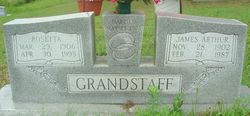
Rosetta Perkins Grandstaff
| Birth | : | 29 Mar 1906 Oregon County, Missouri, USA |
| Death | : | 30 Apr 1993 |
| Burial | : | Ebeneezer Chapel, Biddenden, Ashford Borough, England |
| Coordinate | : | 51.1383320, 0.6416030 |
| Inscription | : | Married 23 May 1923 |
| Description | : | Rosetta Perkins in the 1920 United States Federal Census Name: Rosetta Perkins Age: 13 Birth Year: abt 1907 Birthplace: Missouri Home in 1920: Moore, Oregon, Missouri Street: Muddle Fork Veaunty Residence Date: 1920 Race: White Gender: Female Relation to Head of House: Daughter Marital Status: Single Father's Name: William Perkins Father's Birthplace: Missouri Mother's Birthplace: Missouri Native Tongue: English Able to Speak English: Yes Attended School: yes Able to read: Yes Able to Write: Yes Neighbors: View others on page Household Members Age Relationship William Perkins 72 Head Frances Perkins 23 Daughter Clarence Perkins 19 Son Rosetta Perkins 13 Daughter |
frequently asked questions (FAQ):
-
Where is Rosetta Perkins Grandstaff's memorial?
Rosetta Perkins Grandstaff's memorial is located at: Ebeneezer Chapel, Biddenden, Ashford Borough, England.
-
When did Rosetta Perkins Grandstaff death?
Rosetta Perkins Grandstaff death on 30 Apr 1993 in
-
Where are the coordinates of the Rosetta Perkins Grandstaff's memorial?
Latitude: 51.1383320
Longitude: 0.6416030
Family Members:
Parent
Spouse

Siblings
Children


Nearby Cemetories:
1. All Saints Churchyard
Biddenden, Ashford Borough, England
Coordinate: 51.1150740, 0.6403990
2. St. Michael the Archangel Churchyard
Smarden, Ashford Borough, England
Coordinate: 51.1490030, 0.6861940
3. Headcorn Baptist Churchyard
Headcorn, Maidstone Borough, England
Coordinate: 51.1674156, 0.6247670
4. Headcorn Parish Burial Ground
Headcorn, Maidstone Borough, England
Coordinate: 51.1671257, 0.6204750
5. Headcorn Methodist Churchyard
Headcorn, Maidstone Borough, England
Coordinate: 51.1674940, 0.6205670
6. Headcorn War Memorial
Headcorn, Maidstone Borough, England
Coordinate: 51.1677480, 0.6212560
7. St. Mary's Churchyard
Frittenden, Tunbridge Wells Borough, England
Coordinate: 51.1391190, 0.5904720
8. St. Peter and St. Paul Churchyard
Headcorn, Maidstone Borough, England
Coordinate: 51.1678543, 0.6203760
9. Frittenden Burial Gound
Frittenden, Tunbridge Wells Borough, England
Coordinate: 51.1428480, 0.5870820
10. Sissinghurst Cemetery
Sissinghurst, Tunbridge Wells Borough, England
Coordinate: 51.1095310, 0.5629240
11. St. Mary the Virgin Churchyard
High Halden, Ashford Borough, England
Coordinate: 51.1028950, 0.7148620
12. All Saints Church
Staplehurst, Maidstone Borough, England
Coordinate: 51.1582160, 0.5527170
13. St. Michael and All Angels Churchyard
Tenterden, Ashford Borough, England
Coordinate: 51.0867424, 0.6894140
14. Marian Martyrs Memorial
Staplehurst, Maidstone Borough, England
Coordinate: 51.1649780, 0.5523900
15. Egerton Free Church Graveyard
Egerton, Ashford Borough, England
Coordinate: 51.1871830, 0.7050080
16. Cranbrook Cemetery
Cranbrook, Tunbridge Wells Borough, England
Coordinate: 51.0962250, 0.5541360
17. St. Margaret's Churchyard
Bethersden, Ashford Borough, England
Coordinate: 51.1291440, 0.7538760
18. Unitarian Old Meeting House
Tenterden, Ashford Borough, England
Coordinate: 51.0717468, 0.6906880
19. Tenterden Cemetery
Tenterden, Ashford Borough, England
Coordinate: 51.0676820, 0.6737140
20. Station Road Extension
Tenterden, Ashford Borough, England
Coordinate: 51.0686640, 0.6852830
21. St. Mildred's Churchyard
Tenterden, Ashford Borough, England
Coordinate: 51.0686264, 0.6870960
22. St Dunstan's Churchyard
Cranbrook, Tunbridge Wells Borough, England
Coordinate: 51.0973030, 0.5363690
23. St David's Bridge Strict Baptist Chapel
Cranbrook, Tunbridge Wells Borough, England
Coordinate: 51.0953430, 0.5378980
24. All Saints Churchyard
Ulcombe, Maidstone Borough, England
Coordinate: 51.2171930, 0.6426440