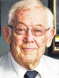
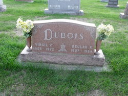
Ross Eugene “Gene” Dubois
| Birth | : | 20 Nov 1926 |
| Death | : | 16 May 2018 Cridersville, Auglaize County, Ohio, USA |
| Burial | : | St Cuthbert's Churchyard, Brattleby, West Lindsey District, England |
| Coordinate | : | 53.3156600, -0.5794750 |
| Plot | : | Section K, Row 5 |
| Description | : | Ross E. "Gene" DuBois age 91, of Cridersville passed away 8:25 a.m., Wednesday May 16, 2018 at Otterbein, Cridersville. He was born Nov. 20, 1926 to the late Virgil Victor and Beulah Roser DuBois. He married May Lou Crouse May 2, 1948 and she preceded him in death May 21, 2014. Gene had been the manager of The Paint Store in Lima. He was a member of Cridersville United Methodist Church and took playing cards very seriously. He had served in the U.S. Navy during WW II and was a member of the American Legion in Lima and the... Read More |
frequently asked questions (FAQ):
-
Where is Ross Eugene “Gene” Dubois's memorial?
Ross Eugene “Gene” Dubois's memorial is located at: St Cuthbert's Churchyard, Brattleby, West Lindsey District, England.
-
When did Ross Eugene “Gene” Dubois death?
Ross Eugene “Gene” Dubois death on 16 May 2018 in Cridersville, Auglaize County, Ohio, USA
-
Where are the coordinates of the Ross Eugene “Gene” Dubois's memorial?
Latitude: 53.3156600
Longitude: -0.5794750
Family Members:
Parent
Spouse
Flowers:
Nearby Cemetories:
1. St Cuthbert's Churchyard
Brattleby, West Lindsey District, England
Coordinate: 53.3156600, -0.5794750
2. St Peter's Churchyard
Aisthorpe, West Lindsey District, England
Coordinate: 53.3102400, -0.5815300
3. St. John the Baptist Churchyard
Scampton, West Lindsey District, England
Coordinate: 53.3037680, -0.5787140
4. St. Michael's Churchyard
Cammeringham, West Lindsey District, England
Coordinate: 53.3275480, -0.5781450
5. Dam Busters Dog Memorial
Scampton, West Lindsey District, England
Coordinate: 53.3008200, -0.5495800
6. All Saints Churchyard
Ingham, West Lindsey District, England
Coordinate: 53.3398690, -0.5745610
7. St. Luke's Churchyard
North Carlton, West Lindsey District, England
Coordinate: 53.2873000, -0.5831200
8. St. John the Baptist Churchyard
South Carlton, West Lindsey District, England
Coordinate: 53.2785000, -0.5754000
9. All Saints Churchyard
Broxholme, West Lindsey District, England
Coordinate: 53.2922400, -0.6349600
10. St. Edith Churchyard
Coates-by-Stow, West Lindsey District, England
Coordinate: 53.3369700, -0.6377300
11. St Michael Churchyard
Hackthorn, West Lindsey District, England
Coordinate: 53.3288810, -0.5134350
12. Sturton by Stow Quaker Cemetery
Sturton-by-Stow, West Lindsey District, England
Coordinate: 53.3173590, -0.6644260
13. Sturton by Stow
Sturton-by-Stow, West Lindsey District, England
Coordinate: 53.3192800, -0.6677000
14. St. Mary's Churchyard
Riseholme, West Lindsey District, England
Coordinate: 53.2688200, -0.5264900
15. St. Vincent Churchyard
Burton, West Lindsey District, England
Coordinate: 53.2596400, -0.5598100
16. Stow Cemetery
Stow, West Lindsey District, England
Coordinate: 53.3252100, -0.6811100
17. Saxilby Cemetery
Saxilby, West Lindsey District, England
Coordinate: 53.2755800, -0.6590400
18. St. Botolph Churchyard
Saxilby, West Lindsey District, England
Coordinate: 53.2747300, -0.6591000
19. St. Michael's Churchyard
Glentworth, West Lindsey District, England
Coordinate: 53.3813420, -0.5794550
20. Glentworth Cemetery
Glentworth, West Lindsey District, England
Coordinate: 53.3823126, -0.5768907
21. St. Helen's Churchyard
Saxby, West Lindsey District, England
Coordinate: 53.3625100, -0.4920400
22. St. Chad Churchyard
Dunholme, West Lindsey District, England
Coordinate: 53.3018330, -0.4638100
23. St Chad Church Extension
Dunholme, West Lindsey District, England
Coordinate: 53.3008900, -0.4621500
24. All Saints Churchyard
Nettleham, West Lindsey District, England
Coordinate: 53.2652940, -0.4906780


