


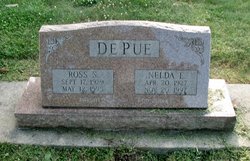
Ross S DePue
| Birth | : | 17 Sep 1929 Clinton County, Iowa, USA |
| Death | : | 12 May 1995 Waterloo, Black Hawk County, Iowa, USA |
| Burial | : | Wheatley Lane Inghamite Church Churchyard, Wheatley Lane, Pendle Borough, England |
| Coordinate | : | 53.8412800, -2.2457100 |
| Plot | : | Section L, block 271 |
| Description | : | Ross DePue Ross DePue, 65, of 1714 3rd Ave. N.W., Waverly, Iowa, died Friday afternoon, May 12, 1995, at the emergency room of Allen Memorial Hospital in Waterloo, Iowa, from an apparent heart attack. He was born on September 17, 1929, in Clinton, Iowa, the son of Ambrose and Alice (Sizer) DePue. Ross was baptized in 1930 in the Preston Methodist Church where he was a member until 1953. He and his family lived in Preston, Iowa, where he attended school, graduating in 1947. He then attended Cornell College in Mr. Vernon, Iowa, graduating with his B.A. in 1951. On... Read More |
frequently asked questions (FAQ):
-
Where is Ross S DePue's memorial?
Ross S DePue's memorial is located at: Wheatley Lane Inghamite Church Churchyard, Wheatley Lane, Pendle Borough, England.
-
When did Ross S DePue death?
Ross S DePue death on 12 May 1995 in Waterloo, Black Hawk County, Iowa, USA
-
Where are the coordinates of the Ross S DePue's memorial?
Latitude: 53.8412800
Longitude: -2.2457100
Family Members:
Parent

Spouse
Flowers:


Nearby Cemetories:
1. Wheatley Lane Inghamite Church Churchyard
Wheatley Lane, Pendle Borough, England
Coordinate: 53.8412800, -2.2457100
2. All Souls Cemetery
Barrowford, Pendle Borough, England
Coordinate: 53.8462900, -2.2355600
3. Wheatley Lane Methodist Churchyard
Fence, Pendle Borough, England
Coordinate: 53.8341457, -2.2596202
4. St. Anne Churchyard
Fence, Pendle Borough, England
Coordinate: 53.8304372, -2.2679552
5. St. Mary's Churchyard
Newchurch in Pendle, Pendle Borough, England
Coordinate: 53.8504181, -2.2706807
6. St. Thomas Churchyard
Barrowford, Pendle Borough, England
Coordinate: 53.8513900, -2.2196600
7. St. Paul's Churchyard
Nelson, Pendle Borough, England
Coordinate: 53.8289250, -2.2157520
8. Barrowford Cemetery
Nelson, Pendle Borough, England
Coordinate: 53.8521100, -2.2130300
9. Marsden Friends Burial Ground
Marsden, Metropolitan Borough of Kirklees, England
Coordinate: 53.8241910, -2.2197410
10. Nelson Cemetery
Nelson, Pendle Borough, England
Coordinate: 53.8420330, -2.1972230
11. St. John the Evangelist Churchyard
Nelson, Pendle Borough, England
Coordinate: 53.8367000, -2.1977200
12. St John Churchyard
Higham, Pendle Borough, England
Coordinate: 53.8251420, -2.2898120
13. St. James' Churchyard
Briercliffe, Burnley Borough, England
Coordinate: 53.8107700, -2.2031800
14. Haggate Baptist Church Burial Ground
Burnley Borough, England
Coordinate: 53.8145048, -2.1960725
15. Hill Lane Baptist Church Churchyard
Briercliffe, Burnley Borough, England
Coordinate: 53.8161467, -2.1875368
16. Ebenezer Baptist Chapel Chapelyard
Burnley, Burnley Borough, England
Coordinate: 53.7975120, -2.2397260
17. St. Bartholomew Churchyard
Colne, Pendle Borough, England
Coordinate: 53.8570600, -2.1700470
18. West Street Inghamite Chapel Chapelyard
Colne, Pendle Borough, England
Coordinate: 53.8555930, -2.1672140
19. St. Peter's Churchyard
Burnley, Burnley Borough, England
Coordinate: 53.7924450, -2.2394890
20. John Ecroyd's Orchard
Lancaster, City of Lancaster, England
Coordinate: 53.8201990, -2.1697920
21. Twiston Quaker Burial Ground
Clitheroe, Ribble Valley Borough, England
Coordinate: 53.8854210, -2.2838840
22. St. James' Churchyard
Burnley, Burnley Borough, England
Coordinate: 53.7905590, -2.2458280
23. All Saints Churchyard
Habergham Eaves, Burnley Borough, England
Coordinate: 53.7971060, -2.2913770
24. Holy Trinity Churchyard
Burnley, Burnley Borough, England
Coordinate: 53.7898290, -2.2574200