
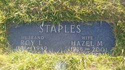
Roy Leslie Staples
| Birth | : | 9 Oct 1911 Havre, Hill County, Montana, USA |
| Death | : | 1 Sep 1989 Havre, Hill County, Montana, USA |
| Burial | : | Highland Cemetery, Havre, Hill County, USA |
| Coordinate | : | 48.5463982, -109.6900024 |
| Plot | : | 341 33 |
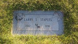
| Description | : | Havre--Roy L Staples, 77, died of natural causes Friday at a Havre hospital. Service is at 2pm Wednesday at Holland and Bonine Chapel, with burial in Highland Cemetery. Born at Havre, he attended Cottonwood School north of town. In 1936, he married Hazel Schuman in Lewistown. They farmed north of Havre until retiring to town in 1969. Survivors: wife, children, Les and Larry, both north of Havre; Phyllis White of Fresno, CA; sister, Ethel McSloy, north of Havre; brothers, Gerald of Kamloops, B.C., James of Havre, Jack of Kalispell; five grandchildren and three great-grandchildren. [Great Falls Tribune (MT),... Read More |
frequently asked questions (FAQ):
-
Where is Roy Leslie Staples's memorial?
Roy Leslie Staples's memorial is located at: Highland Cemetery, Havre, Hill County, USA.
-
When did Roy Leslie Staples death?
Roy Leslie Staples death on 1 Sep 1989 in Havre, Hill County, Montana, USA
-
Where are the coordinates of the Roy Leslie Staples's memorial?
Latitude: 48.5463982
Longitude: -109.6900024
Family Members:
Parent
Spouse

Siblings

Children
Flowers:


Nearby Cemetories:
1. Highland Cemetery
Havre, Hill County, USA
Coordinate: 48.5463982, -109.6900024
2. Calvary Cemetery
Havre, Hill County, USA
Coordinate: 48.5457000, -109.6883000
3. Mount Hope Cemetery
Havre, Hill County, USA
Coordinate: 48.5540000, -109.7050000
4. Sunset Garden Park
Havre, Hill County, USA
Coordinate: 48.5531006, -109.8019028
5. North Havre Lutheran Church Graveyard (Defunct)
Havre, Hill County, USA
Coordinate: 48.6538903, -109.6815870
6. Grainbelt Cemetery
Hill County, USA
Coordinate: 48.6828003, -109.8657990
7. Andrew S. Lohman Grave Site
Lohman, Blaine County, USA
Coordinate: 48.5903520, -109.4073350
8. East End Colony Cemetery
East End Colony, Hill County, USA
Coordinate: 48.7485000, -109.5474000
9. Hilldale Hutterite Colony Cemetery
Hilldale Colony, Hill County, USA
Coordinate: 48.7997000, -109.7872000
10. Saint Johns Catholic Cemetery
Havre, Hill County, USA
Coordinate: 48.7625008, -109.9638977
11. Saint Gabriel Cemetery
Chinook, Blaine County, USA
Coordinate: 48.6065200, -109.2531200
12. Kuper Memorial Cemetery
Chinook, Blaine County, USA
Coordinate: 48.6083100, -109.2531200
13. Rocky Boy Cemetery
Rocky Boy, Hill County, USA
Coordinate: 48.2572410, -109.7923690
14. Box Elder Cemetery
Box Elder, Hill County, USA
Coordinate: 48.3274000, -110.0095000
15. Rocky Boy Gravel Cemetery
Rocky Boy, Hill County, USA
Coordinate: 48.2427720, -109.7596500
16. Cottonwood Lutheran Church Cemetery
Havre, Hill County, USA
Coordinate: 48.4545000, -110.1748000
17. Bear Paw Battlefield
Chinook, Blaine County, USA
Coordinate: 48.3780070, -109.2121290
18. Hungry Hollow Cemetery
Blaine County, USA
Coordinate: 48.2103004, -109.4677963
19. Milk River Valley Church Graveyard
Hill County, USA
Coordinate: 48.6787180, -110.2261080
20. Hollandville Cemetery
Chinook, Blaine County, USA
Coordinate: 48.6960310, -109.1557200
21. Gildford Hill County Cemetery
Gildford, Hill County, USA
Coordinate: 48.5778008, -110.2957993
22. Prairie Chapel United Brethren Cemetery
Chinook, Blaine County, USA
Coordinate: 48.8860000, -109.3414000
23. Mennonite Brethren Cemetery
Chinook, Blaine County, USA
Coordinate: 48.8012560, -109.1980620
24. Bethel Bruderthaler Mennonite Church Cemetery
Chinook, Blaine County, USA
Coordinate: 48.7552000, -109.1345000