
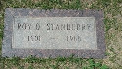
Roy O. Stanberry
| Birth | : | 7 Jun 1901 Springfield, Sangamon County, Illinois, USA |
| Death | : | 23 Nov 1968 Rudyard, Hill County, Montana, USA |
| Burial | : | Highland Cemetery, Havre, Hill County, USA |
| Coordinate | : | 48.5463982, -109.6900024 |
| Description | : | Liberty County Times, Chester, MT, 5 Dec 1968 Roy Stanberry Roy Stanberry, 67, Died November 23, Services Nov. 26 Roy O. Stanberry, 67, Rudyard, died at his home Saturday, Nov. 23. Funeral services were at Holland and Bonine Funeral Home. Pall bearers were Ben Bradbury, Robert Toner, Alvin Barbie, Howard Schultz, Irvin Brandt and John Morrissey. Ellsworth Graff and Charles Lineweaver ushered. Interment was in Highland Cemetery. Roy Stanberry was born June 7, 1901 in Springfield, Ill. He came to Montana in 1916 with his parents, lived north of Gildford and later moved north of Havre. He... Read More |
frequently asked questions (FAQ):
-
Where is Roy O. Stanberry's memorial?
Roy O. Stanberry's memorial is located at: Highland Cemetery, Havre, Hill County, USA.
-
When did Roy O. Stanberry death?
Roy O. Stanberry death on 23 Nov 1968 in Rudyard, Hill County, Montana, USA
-
Where are the coordinates of the Roy O. Stanberry's memorial?
Latitude: 48.5463982
Longitude: -109.6900024
Family Members:
Spouse
Children
Flowers:


Nearby Cemetories:
1. Highland Cemetery
Havre, Hill County, USA
Coordinate: 48.5463982, -109.6900024
2. Calvary Cemetery
Havre, Hill County, USA
Coordinate: 48.5457000, -109.6883000
3. Mount Hope Cemetery
Havre, Hill County, USA
Coordinate: 48.5540000, -109.7050000
4. Sunset Garden Park
Havre, Hill County, USA
Coordinate: 48.5531006, -109.8019028
5. North Havre Lutheran Church Graveyard (Defunct)
Havre, Hill County, USA
Coordinate: 48.6538903, -109.6815870
6. Grainbelt Cemetery
Hill County, USA
Coordinate: 48.6828003, -109.8657990
7. Andrew S. Lohman Grave Site
Lohman, Blaine County, USA
Coordinate: 48.5903520, -109.4073350
8. East End Colony Cemetery
East End Colony, Hill County, USA
Coordinate: 48.7485000, -109.5474000
9. Hilldale Hutterite Colony Cemetery
Hilldale Colony, Hill County, USA
Coordinate: 48.7997000, -109.7872000
10. Saint Johns Catholic Cemetery
Havre, Hill County, USA
Coordinate: 48.7625008, -109.9638977
11. Saint Gabriel Cemetery
Chinook, Blaine County, USA
Coordinate: 48.6065200, -109.2531200
12. Kuper Memorial Cemetery
Chinook, Blaine County, USA
Coordinate: 48.6083100, -109.2531200
13. Rocky Boy Cemetery
Rocky Boy, Hill County, USA
Coordinate: 48.2572410, -109.7923690
14. Box Elder Cemetery
Box Elder, Hill County, USA
Coordinate: 48.3274000, -110.0095000
15. Rocky Boy Gravel Cemetery
Rocky Boy, Hill County, USA
Coordinate: 48.2427720, -109.7596500
16. Cottonwood Lutheran Church Cemetery
Havre, Hill County, USA
Coordinate: 48.4545000, -110.1748000
17. Bear Paw Battlefield
Chinook, Blaine County, USA
Coordinate: 48.3780070, -109.2121290
18. Hungry Hollow Cemetery
Blaine County, USA
Coordinate: 48.2103004, -109.4677963
19. Milk River Valley Church Graveyard
Hill County, USA
Coordinate: 48.6787180, -110.2261080
20. Hollandville Cemetery
Chinook, Blaine County, USA
Coordinate: 48.6960310, -109.1557200
21. Gildford Hill County Cemetery
Gildford, Hill County, USA
Coordinate: 48.5778008, -110.2957993
22. Prairie Chapel United Brethren Cemetery
Chinook, Blaine County, USA
Coordinate: 48.8860000, -109.3414000
23. Mennonite Brethren Cemetery
Chinook, Blaine County, USA
Coordinate: 48.8012560, -109.1980620
24. Bethel Bruderthaler Mennonite Church Cemetery
Chinook, Blaine County, USA
Coordinate: 48.7552000, -109.1345000