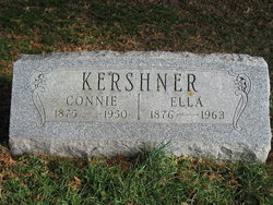
Rozella “Ella” Preston Kershner
| Birth | : | 27 Jan 1876 Cass, Jones County, Iowa, USA |
| Death | : | 7 Feb 1963 Anamosa, Jones County, Iowa, USA |
| Burial | : | Ogallala Cemetery, Ogallala, Keith County, USA |
| Coordinate | : | 41.1286011, -101.7472000 |
| Plot | : | Row 25 |
| Description | : | ss. Connie Kershner ---------- SOURCE: THE ANAMOSA JOURNAL…FEBRUARY 11, 1963…PAGE 4 Mrs. R. Kershner Of Anamosa Dies Funeral Services Held | On Saturday, Feb. 9th Mrs. Rozella Kershner, 87, Anamosa, died Thursday, Feb. 7, at Mercy hospital, Anamosa, following a brief illness. Funeral services were held Saturday, Feb. 9, at 2 p.m., at the Goettsch Funeral home, Anamosa. Rev. J. Ellis Webb, Anamosa, officiated at the service. Burial was in the Wilcox cemetery. Pallbearers were grandsons of Mrs. Kershner, including, Robert Soper, William Walderbach, Cecil Anderson, Edward Anderson, Raymond Anderson and George Pillard. Life Outlined She was born Jan. 27, 1876, daughter of Charles Preston and Nanny Smith... Read More |
frequently asked questions (FAQ):
-
Where is Rozella “Ella” Preston Kershner's memorial?
Rozella “Ella” Preston Kershner's memorial is located at: Ogallala Cemetery, Ogallala, Keith County, USA.
-
When did Rozella “Ella” Preston Kershner death?
Rozella “Ella” Preston Kershner death on 7 Feb 1963 in Anamosa, Jones County, Iowa, USA
-
Where are the coordinates of the Rozella “Ella” Preston Kershner's memorial?
Latitude: 41.1286011
Longitude: -101.7472000
Family Members:
Parent
Spouse
Children
Flowers:
Nearby Cemetories:
1. Ogallala Cemetery
Ogallala, Keith County, USA
Coordinate: 41.1286011, -101.7472000
2. Boot Hill Cemetery
Ogallala, Keith County, USA
Coordinate: 41.1324997, -101.7256012
3. Brule Cemetery
Brule, Keith County, USA
Coordinate: 41.1060982, -101.8822021
4. Saint John's Lutheran Church Cemetery
Ogallala, Keith County, USA
Coordinate: 41.0617000, -101.5983000
5. Lemoyne Cemetery
Lemoyne, Keith County, USA
Coordinate: 41.2723000, -101.8123000
6. Trinity Lutheran Cemetery
Grant, Perkins County, USA
Coordinate: 40.9605000, -101.7478000
7. Pickard Cemetery
Keith County, USA
Coordinate: 41.0482240, -101.4809320
8. Big Springs Cemetery
Big Springs, Deuel County, USA
Coordinate: 41.0592003, -102.0931015
9. Fairview Cemetery
Grant, Perkins County, USA
Coordinate: 40.8372002, -101.7391968
10. Paxton Cemetery
Paxton, Keith County, USA
Coordinate: 41.1088982, -101.3569031
11. Day Cemetery
Deuel County, USA
Coordinate: 41.1921997, -102.1331024
12. Zion Cemetery
Deuel County, USA
Coordinate: 41.1641998, -102.1530991
13. Madrid Cemetery
Madrid, Perkins County, USA
Coordinate: 40.8371510, -101.5380900
14. Plum Creek Cemetery
Garden County, USA
Coordinate: 41.3469009, -102.0828018
15. Ash Hollow Cemetery
Lewellen, Garden County, USA
Coordinate: 41.3083000, -102.1252975
16. Ash Creek Cemetery
Lewellen, Garden County, USA
Coordinate: 41.3521996, -102.1205978
17. Walpole Cemetery
Perkins County, USA
Coordinate: 40.9157982, -101.3422012
18. Frontier Cemetery
Sutherland, Lincoln County, USA
Coordinate: 41.0912000, -101.2531000
19. Glen Echo Church Cemetery
Paxton, Keith County, USA
Coordinate: 41.3228320, -101.3084220
20. Fairview Cemetery
Garden County, USA
Coordinate: 41.4524994, -102.0233002
21. Elsie Cemetery
Elsie, Perkins County, USA
Coordinate: 40.8499050, -101.3666140
22. Durham Cemetery
Garden County, USA
Coordinate: 41.3314018, -102.2074966
23. Hillside Cemetery
Julesburg, Sedgwick County, USA
Coordinate: 40.9692001, -102.2406006
24. Arthur Cemetery
Arthur, Arthur County, USA
Coordinate: 41.5646530, -101.7058360


