
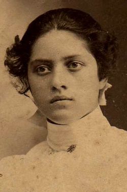
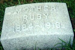
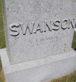
Ruby Day Swanson
| Birth | : | 2 Nov 1884 Lorimor, Union County, Iowa, USA |
| Death | : | 1918 Lorimor, Union County, Iowa, USA |
| Burial | : | Fairmount Cemetery, Presque Isle, Aroostook County, USA |
| Coordinate | : | 46.6628075, -68.0077744 |
| Plot | : | Lot 163 |
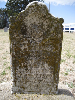
| Description | : | Ruby Day - daughter of Thomas Wesley and Margaret Little Day. Married to G. Al Swanson. Mother of two sons, Day and Robert. When Ruby was six years old, she fell from a swing and hit the back of her head. From then on she would have convulsions off and on and the Drs were never able to find anything to help her. She died at the age of 34. Her husband, Al Swanson owned a clothing store in Lorimor, Iowa during there years there. After Rubys death, ... Read More |
frequently asked questions (FAQ):
-
Where is Ruby Day Swanson's memorial?
Ruby Day Swanson's memorial is located at: Fairmount Cemetery, Presque Isle, Aroostook County, USA.
-
When did Ruby Day Swanson death?
Ruby Day Swanson death on 1918 in Lorimor, Union County, Iowa, USA
-
Where are the coordinates of the Ruby Day Swanson's memorial?
Latitude: 46.6628075
Longitude: -68.0077744
Family Members:
Parent

Spouse
Siblings
Flowers:


Nearby Cemetories:
1. Fairmount Cemetery
Presque Isle, Aroostook County, USA
Coordinate: 46.6628075, -68.0077744
2. Saint Marys Chapman Street Cemetery
Presque Isle, Aroostook County, USA
Coordinate: 46.6754150, -68.0215990
3. Bartlett Cemetery
Presque Isle, Aroostook County, USA
Coordinate: 46.6765327, -67.9827118
4. Saint Marys Cemetery
Presque Isle, Aroostook County, USA
Coordinate: 46.6930930, -68.0104730
5. Johnson Cemetery
Presque Isle, Aroostook County, USA
Coordinate: 46.7078209, -68.0069733
6. Reuben Bean Family Cemetery
Aroostook County, USA
Coordinate: 46.7141610, -67.9514610
7. Estes Park Cemetery
Easton, Aroostook County, USA
Coordinate: 46.6418110, -67.9181820
8. Bean Family Cemetery
Aroostook County, USA
Coordinate: 46.7396440, -67.9542600
9. Grendell Cemetery
Chapman, Aroostook County, USA
Coordinate: 46.6364010, -68.1318340
10. Knight Cemetery
Fort Fairfield, Aroostook County, USA
Coordinate: 46.6876150, -67.8778140
11. Pine Tree Cemetery
Easton, Aroostook County, USA
Coordinate: 46.6774640, -67.8727940
12. Mount Shiloh Cemetery
Easton, Aroostook County, USA
Coordinate: 46.6362460, -67.8670810
13. Hillside Grove Cemetery
Crouseville, Aroostook County, USA
Coordinate: 46.7566760, -68.0765500
14. Crouseville Cemetery
Crouseville, Aroostook County, USA
Coordinate: 46.7574997, -68.0768967
15. Old Mill Town Cemetery
Mapleton, Aroostook County, USA
Coordinate: 46.6815700, -68.1609100
16. Southside Cemetery
Mapleton, Aroostook County, USA
Coordinate: 46.6622050, -68.1633620
17. Marshall Cemetery
Westfield, Aroostook County, USA
Coordinate: 46.5635986, -67.9464035
18. Haines Maple Grove Cemetery
Fort Fairfield, Aroostook County, USA
Coordinate: 46.7233160, -67.8699040
19. Ladner Cemetery
Easton, Aroostook County, USA
Coordinate: 46.6444170, -67.8149570
20. Union Cemetery
Fort Fairfield, Aroostook County, USA
Coordinate: 46.7566150, -67.8655240
21. Harvey Hill Cemetery
McShea, Aroostook County, USA
Coordinate: 46.7567099, -67.8652997
22. Castle Hill Cemetery
Castle Hill, Aroostook County, USA
Coordinate: 46.7346840, -68.1792210
23. Greenridge Cemetery
Caribou, Aroostook County, USA
Coordinate: 46.7923622, -67.9321976
24. Lyndon Center Cemetery
Caribou, Aroostook County, USA
Coordinate: 46.8022240, -67.9921920