
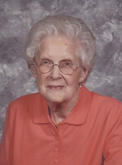
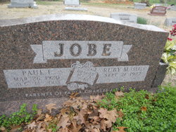
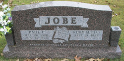
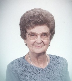
Ruby Marie Serl Jobe
| Birth | : | 21 Sep 1922 Decatur, Cole County, Missouri, USA |
| Death | : | 19 Jul 2012 Jefferson City, Cole County, Missouri, USA |
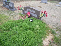
| Burial | : | Allen Cemetery, Olean, Miller County, USA |
| Coordinate | : | 38.4150009, -92.5008011 |
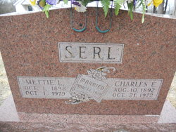
| Description | : | Ruby Marie (Serl) Job 89 of Jefferson City, passed away Thursday afternoon July 19, 2012 at Oak Tree Villa in Jefferson City Mo. On September 21, 1922 she was born in Decatur Mo the daughter of the late Charles E. and Mattie Lee (Hader) Serl. On Decembr 28, 1940 she was married in Eldon Mo. to Paul I. Jobe who preceded her in death on August 13, 2003. Survivors daughter and son in law, Paula and Jim Allison of Jefferson City Mo. Sons and daughter in law, Charles and Kathleen Jobe of Russellville Mo. David and Martha Jobe of Jefferson City... Read More |
frequently asked questions (FAQ):
-
Where is Ruby Marie Serl Jobe's memorial?
Ruby Marie Serl Jobe's memorial is located at: Allen Cemetery, Olean, Miller County, USA.
-
When did Ruby Marie Serl Jobe death?
Ruby Marie Serl Jobe death on 19 Jul 2012 in Jefferson City, Cole County, Missouri, USA
-
Where are the coordinates of the Ruby Marie Serl Jobe's memorial?
Latitude: 38.4150009
Longitude: -92.5008011
Family Members:
Parent

Spouse
Siblings
Flowers:


Nearby Cemetories:
1. Allen Cemetery
Olean, Miller County, USA
Coordinate: 38.4150009, -92.5008011
2. Olean Cemetery
Olean, Miller County, USA
Coordinate: 38.4131012, -92.5413971
3. Farris Cemetery
Moniteau County, USA
Coordinate: 38.4369900, -92.5380000
4. Jackson Chapel Methodist Church Cemetery
California, Moniteau County, USA
Coordinate: 38.4447900, -92.5286500
5. Walker Cemetery
Moniteau County, USA
Coordinate: 38.4338989, -92.5522003
6. Etter-Walker Cemetery
Burris Fork, Moniteau County, USA
Coordinate: 38.4333700, -92.5525400
7. Green Ridge Baptist Church Cemetery
Eldon, Miller County, USA
Coordinate: 38.4116200, -92.5645700
8. Gray Cemetery
Moniteau County, USA
Coordinate: 38.4536018, -92.5456009
9. Bruce-Lewis-McGahan Cemetery
Enon, Moniteau County, USA
Coordinate: 38.4667500, -92.5172100
10. Rock Enon Cemetery
Miller County, USA
Coordinate: 38.4668400, -92.5170700
11. Mount Pleasant Cemetery
Eldon, Miller County, USA
Coordinate: 38.3667700, -92.5300800
12. Matheis Cemetery
Russellville, Cole County, USA
Coordinate: 38.4571800, -92.4491600
13. Mount Vernon Cemetery
Eldon, Miller County, USA
Coordinate: 38.3624992, -92.5606003
14. Salem Cemetery
Saline Township, Miller County, USA
Coordinate: 38.3691232, -92.5697260
15. Salem Cemetery
Eldon, Miller County, USA
Coordinate: 38.3697014, -92.5714035
16. Hite Cemetery
Miller County, USA
Coordinate: 38.4039001, -92.5935974
17. Spring Garden Cemetery
Spring Garden, Miller County, USA
Coordinate: 38.3922005, -92.4111023
18. Enon Cemetery
Russellville, Cole County, USA
Coordinate: 38.4888992, -92.4730988
19. Roark Cemetery
Russellville, Cole County, USA
Coordinate: 38.4696999, -92.4255981
20. Karnes-Carney-Henderson Cemetery
Burris Fork, Moniteau County, USA
Coordinate: 38.4992100, -92.5007510
21. Eldon Cemetery
Eldon, Miller County, USA
Coordinate: 38.3642006, -92.5868988
22. Belleville Cemetery
Russellville, Cole County, USA
Coordinate: 38.4970490, -92.4667150
23. Campbell Cemetery
Cole County, USA
Coordinate: 38.4810982, -92.4297028
24. Farmer Cemetery
Hickory Hill, Cole County, USA
Coordinate: 38.4143500, -92.3889790