
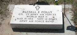
Russell Earl Polly
| Birth | : | 31 Mar 1914 Wauneta, Chase County, Nebraska, USA |
| Death | : | 12 Nov 2003 Lincoln, Lancaster County, Nebraska, USA |
| Burial | : | Euxton Parish Churchyard, Euxton, Chorley Borough, England |
| Coordinate | : | 53.6650950, -2.6743630 |
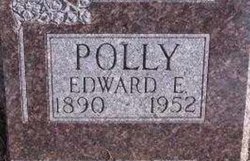
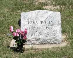
| Description | : | LINCOLN -- Russell Earl Polly, 89, long time resident of Wauneta, died Wednesday (Nov. 12, 2003) the Nebraska Heart Institute in Lincoln. He was born March 31, 1914, to Edward David and Veva (Pence) Polly on the family farm east of Wauneta. He attended grade school at Sunny Side School in Chase County. He skipped grades three and seven. He graduated from Wauneta High School in 1931. He was the class president, a honor student and salutatorian of the class. He worked on the family farm. He enlisted in the Army Air Corps Nov. 7, 1942. He was a member... Read More |
frequently asked questions (FAQ):
-
Where is Russell Earl Polly's memorial?
Russell Earl Polly's memorial is located at: Euxton Parish Churchyard, Euxton, Chorley Borough, England.
-
When did Russell Earl Polly death?
Russell Earl Polly death on 12 Nov 2003 in Lincoln, Lancaster County, Nebraska, USA
-
Where are the coordinates of the Russell Earl Polly's memorial?
Latitude: 53.6650950
Longitude: -2.6743630
Family Members:
Parent
Spouse
Siblings
Flowers:


Nearby Cemetories:
1. Euxton Parish Churchyard
Euxton, Chorley Borough, England
Coordinate: 53.6650950, -2.6743630
2. St. Mary's Churchyard
Euxton, Chorley Borough, England
Coordinate: 53.6669580, -2.6768350
3. Charnock Richard Crematorium
Chorley, Chorley Borough, England
Coordinate: 53.6518550, -2.6763080
4. Chorley Cemetery
Chorley, Chorley Borough, England
Coordinate: 53.6549770, -2.6447530
5. Saint Andrews Churchyard
Leyland, South Ribble Borough, England
Coordinate: 53.6881270, -2.6957880
6. St Laurence's Church
Chorley, Chorley Borough, England
Coordinate: 53.6546880, -2.6327020
7. St Mary's Roman Catholic Churchyard
Leyland, South Ribble Borough, England
Coordinate: 53.6880510, -2.6983240
8. Christ Church
Charnock Richard, Chorley Borough, England
Coordinate: 53.6367200, -2.6773400
9. St George's Churchyard
Chorley, Chorley Borough, England
Coordinate: 53.6521460, -2.6295520
10. St Peters Churchyard
Chorley, Chorley Borough, England
Coordinate: 53.6607430, -2.6232100
11. St John the Evangelist Churchyard
Whittle-le-Woods, Chorley Borough, England
Coordinate: 53.6883280, -2.6400320
12. St Gregory Weld Bank Church Cemetery
Chorley, Chorley Borough, England
Coordinate: 53.6390300, -2.6307480
13. St Mary the Virgin Churchyard
Eccleston, Chorley Borough, England
Coordinate: 53.6528800, -2.7331920
14. St. Chad's South Hill Churchyard
Wheelton, Chorley Borough, England
Coordinate: 53.6826040, -2.6125010
15. Saint James Churchyard
Leyland, South Ribble Borough, England
Coordinate: 53.6896630, -2.7327430
16. St Oswald’s Churchyard
Coppull, Chorley Borough, England
Coordinate: 53.6217176, -2.6714738
17. St Barnabas Churchyard
Heapey, Chorley Borough, England
Coordinate: 53.6792520, -2.6043310
18. St. Bedes Churchyard
Clayton-le-Woods, Chorley Borough, England
Coordinate: 53.7079260, -2.6390320
19. Coppull Parish Churchyard Extension
Coppull, Chorley Borough, England
Coordinate: 53.6170200, -2.6555420
20. Coppull Parish Churchyard
Coppull, Chorley Borough, England
Coordinate: 53.6168000, -2.6549710
21. St. James the Great Churchyard
Wrightington, West Lancashire District, England
Coordinate: 53.6168220, -2.7175670
22. St. Saviour's Churchyard
Bamber Bridge, South Ribble Borough, England
Coordinate: 53.7197301, -2.6598985
23. St. Peter and St. Paul Churchyard
Mawdesley, Chorley Borough, England
Coordinate: 53.6266580, -2.7451420
24. St Paul Churchyard
Farington, South Ribble Borough, England
Coordinate: 53.7199900, -2.7017200