

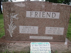
Ruth Ann Turner Friend
| Birth | : | 22 Jan 1938 Morgantown, Monongalia County, West Virginia, USA |
| Death | : | 28 Oct 2013 Beaver, Beaver County, Pennsylvania, USA |
| Burial | : | Oak Grove Church of the Brethren Cemetery, McHenry, Garrett County, USA |
| Coordinate | : | 39.5694400, -79.3834300 |
| Plot | : | Section O, Lot 71, Rt 3 |
| Description | : | Ruth Ann Friend, 75, of Brighton Twp., went home to be with her Lord and Savior, Jesus Christ, on Monday, October 28, 2013, at Heritage Valley Beaver. Born January 22, 1938, in Morgantown, WV, she was a daughter of the late John and Nancy Hayes Turner and had been a resident of Brighton Twp since 1973. Ruth was a faithful member of the Church of the Living Christ, Bridgewater, and was the co-founder of the Holy Spirit Intercessors of Beaver County. She was a 1956 graduate of New Lexington High School, in Ohio. Preceding her in death,... Read More |
frequently asked questions (FAQ):
-
Where is Ruth Ann Turner Friend's memorial?
Ruth Ann Turner Friend's memorial is located at: Oak Grove Church of the Brethren Cemetery, McHenry, Garrett County, USA.
-
When did Ruth Ann Turner Friend death?
Ruth Ann Turner Friend death on 28 Oct 2013 in Beaver, Beaver County, Pennsylvania, USA
-
Where are the coordinates of the Ruth Ann Turner Friend's memorial?
Latitude: 39.5694400
Longitude: -79.3834300
Family Members:
Parent
Spouse

Siblings
Children


Flowers:


Nearby Cemetories:
1. Oak Grove Church of the Brethren Cemetery
McHenry, Garrett County, USA
Coordinate: 39.5694400, -79.3834300
2. Hoye Family Cemetery - Crab Tree Bottom
McHenry, Garrett County, USA
Coordinate: 39.5642220, -79.3855000
3. Saint Dominic Catholic Cemetery
Hoyes, Garrett County, USA
Coordinate: 39.5868300, -79.3698600
4. Hoyes Cemetery
Garrett County, USA
Coordinate: 39.5905991, -79.3683014
5. Upper Sang Run Cemetery
McHenry, Garrett County, USA
Coordinate: 39.5717810, -79.4242430
6. Flatwood Cemetery
Accident, Garrett County, USA
Coordinate: 39.5923500, -79.3515400
7. Skiles Cemetery
Accident, Garrett County, USA
Coordinate: 39.5971570, -79.3439160
8. Bumblebee Ridge Cemetery
McHenry, Garrett County, USA
Coordinate: 39.5774400, -79.3296800
9. Hoyes Run Cemetery
Garrett County, USA
Coordinate: 39.5313100, -79.4110900
10. Bray Cemetery
Oakland, Garrett County, USA
Coordinate: 39.5006900, -79.3858100
11. Glotfelty Farm Cemetery
McHenry, Garrett County, USA
Coordinate: 39.5708800, -79.2905500
12. Bear Creek Church of the Brethren Cemetery
Accident, Garrett County, USA
Coordinate: 39.6213000, -79.3099800
13. Saint Paul's Old Cemetery
Accident, Garrett County, USA
Coordinate: 39.6287100, -79.3182100
14. Friend Cemetery
Oakland, Garrett County, USA
Coordinate: 39.4913500, -79.3778000
15. Ruckle Family Cemetery
Bittinger, Garrett County, USA
Coordinate: 39.5802600, -79.2821900
16. Cherry Glade Cemetery
Accident, Garrett County, USA
Coordinate: 39.5827200, -79.2799500
17. Glade Mennonite Cemetery
Bittinger, Garrett County, USA
Coordinate: 39.5826300, -79.2796700
18. Zion Lutheran Cemetery
Accident, Garrett County, USA
Coordinate: 39.6300510, -79.3129020
19. Taylor-Sines Cemetery
Oakland, Garrett County, USA
Coordinate: 39.4894470, -79.4165480
20. Lake Ford Cemetery
Garrett County, USA
Coordinate: 39.5278015, -79.4792023
21. Cranesville Cemetery
Cranesville, Preston County, USA
Coordinate: 39.5543920, -79.4929870
22. Glendale Cemetery
Oakland, Garrett County, USA
Coordinate: 39.5085983, -79.2953033
23. Rodeheaver Cemetery
Oakland, Garrett County, USA
Coordinate: 39.4804680, -79.3521300
24. Sisler Cemetery
Mountain Dale, Preston County, USA
Coordinate: 39.6081009, -79.4938965