
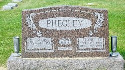
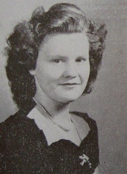
Ruth Eloise Brashier Phegley
| Birth | : | 26 May 1928 Hamilton Township, Sullivan County, Indiana, USA |
| Death | : | 2 May 2016 Terre Haute, Vigo County, Indiana, USA |
| Burial | : | Carlton Cemetery, Nottingham, Nottingham Unitary Authority, England |
| Coordinate | : | 52.9682820, -1.0900230 |
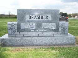
| Description | : | Daughter of James Arthur Brashier Jr. and Inez Evelyn (Mason) Brashier. Married to Leland Carter Phegley on September 21, 1946. Mother of Dale, Denis, Leann and Regina Phegley. OBITUARY: Ruth Eloise (Brashier) Phegley, 87, of Carlisle, passed away on Monday May 2, 2016 at Cobble Stone Crossing Health Campus in Terre Haute. She was born in Sullivan on May 26, 1928 to James and Inez (Mason) Brashier. Eloise was a 1946 Graduate of Carlisle High School, was a bookkeeper for the family business, a member of the Rose Chapel Methodist Church, Sullivan County Home Ec Club for over 60 years, and the Bunco... Read More |
frequently asked questions (FAQ):
-
Where is Ruth Eloise Brashier Phegley's memorial?
Ruth Eloise Brashier Phegley's memorial is located at: Carlton Cemetery, Nottingham, Nottingham Unitary Authority, England.
-
When did Ruth Eloise Brashier Phegley death?
Ruth Eloise Brashier Phegley death on 2 May 2016 in Terre Haute, Vigo County, Indiana, USA
-
Where are the coordinates of the Ruth Eloise Brashier Phegley's memorial?
Latitude: 52.9682820
Longitude: -1.0900230
Family Members:
Parent

Spouse
Flowers:


Nearby Cemetories:
1. Carlton Cemetery
Nottingham, Nottingham Unitary Authority, England
Coordinate: 52.9682820, -1.0900230
2. All Hallows Churchyard
Gedling, Gedling Borough, England
Coordinate: 52.9769400, -1.0805130
3. Gedling Cemetery
Gedling, Gedling Borough, England
Coordinate: 52.9806930, -1.0870670
4. St. Paul's Churchyard
Nottingham Unitary Authority, England
Coordinate: 52.9667590, -1.1172140
5. St. Luke's Churchyard
Stoke Bardolph, Gedling Borough, England
Coordinate: 52.9659896, -1.0404380
6. St Luke's Churchyard
Stoke Bardolph, Gedling Borough, England
Coordinate: 52.9680500, -1.0389300
7. St. Mary Rest Ground
Nottingham, Nottingham Unitary Authority, England
Coordinate: 52.9568310, -1.1406580
8. National Ice Centre
Nottingham, Nottingham Unitary Authority, England
Coordinate: 52.9527790, -1.1394460
9. St Mary's Burial Grounds
Nottingham, Nottingham Unitary Authority, England
Coordinate: 52.9527860, -1.1419160
10. St Mary Churchyard
Radcliffe-on-Trent, Rushcliffe Borough, England
Coordinate: 52.9464660, -1.0419420
11. Burton Joyce Cemetery
Burton Joyce, Gedling Borough, England
Coordinate: 52.9863100, -1.0370710
12. National Justice Museum High Pavement Nottingham
Nottingham Unitary Authority, England
Coordinate: 52.9510680, -1.1443050
13. Radcliffe-on-Trent Cemetery
Radcliffe-on-Trent, Rushcliffe Borough, England
Coordinate: 52.9459200, -1.0409700
14. St. Helen's Churchyard
Burton Joyce, Gedling Borough, England
Coordinate: 52.9866700, -1.0365400
15. St. John's Carrington Churchyard
Nottingham, Nottingham Unitary Authority, England
Coordinate: 52.9755350, -1.1506790
16. St Peters Church Yard
Nottingham, Nottingham Unitary Authority, England
Coordinate: 52.9522800, -1.1486940
17. Nottingham Church Cemetery
Nottingham, Nottingham Unitary Authority, England
Coordinate: 52.9649830, -1.1558070
18. St Nicholas Churchyard
Nottingham, Nottingham Unitary Authority, England
Coordinate: 52.9504780, -1.1509220
19. Cathedral Church of St. Barnabas
Nottingham, Nottingham Unitary Authority, England
Coordinate: 52.9546750, -1.1570460
20. Nottingham General Cemetery
Nottingham, Nottingham Unitary Authority, England
Coordinate: 52.9575370, -1.1594236
21. St. Giles's Church & Churchyard
West Bridgford, Rushcliffe Borough, England
Coordinate: 52.9316460, -1.1288450
22. General Cemetery
Nottingham, Nottingham Unitary Authority, England
Coordinate: 52.9561430, -1.1615420
23. SS Peter & Paul Churchyard
Shelford, Rushcliffe Borough, England
Coordinate: 52.9745600, -1.0161200
24. Hardy Street Jewish Cemetery
Nottingham, Nottingham Unitary Authority, England
Coordinate: 52.9619500, -1.1665900