
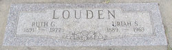
Ruth G. Kimball Louden
| Birth | : | 14 Oct 1891 Ansley, Custer County, Nebraska, USA |
| Death | : | 9 Jun 1977 Columbus, Platte County, Nebraska, USA |
| Burial | : | St. Nicholas Churchyard, Guisborough, Redcar and Cleveland Unitary Authority, England |
| Coordinate | : | 54.5366500, -1.0482800 |
| Description | : | Died at age 85 at the Columbus Community Hospital after a short illness. She had been a resident of Heritage Home. Funeral services will be 2 PM Saturday at Highland Park Evangelical Free Church with Rev. Ray Canderson officiating. Burial will be in Roselawn Memorial Cemetery. The body will lay in state from 1PM Friday until noon on Staurday at McKown Funeral Home and from 1PM until 1PM at the church. She was born in Ansley, NE., to William & Myra Kimball. She married Uriah Louden on April 6th, 1910 at Ansley, where they made their home until 1952 when... Read More |
frequently asked questions (FAQ):
-
Where is Ruth G. Kimball Louden's memorial?
Ruth G. Kimball Louden's memorial is located at: St. Nicholas Churchyard, Guisborough, Redcar and Cleveland Unitary Authority, England.
-
When did Ruth G. Kimball Louden death?
Ruth G. Kimball Louden death on 9 Jun 1977 in Columbus, Platte County, Nebraska, USA
-
Where are the coordinates of the Ruth G. Kimball Louden's memorial?
Latitude: 54.5366500
Longitude: -1.0482800
Family Members:
Spouse

Children
Flowers:


Nearby Cemetories:
1. St. Nicholas Churchyard
Guisborough, Redcar and Cleveland Unitary Authority, England
Coordinate: 54.5366500, -1.0482800
2. Guisborough Priory
Guisborough, Redcar and Cleveland Unitary Authority, England
Coordinate: 54.5361700, -1.0489500
3. Quakers Burial Ground
Guisborough, Redcar and Cleveland Unitary Authority, England
Coordinate: 54.5355100, -1.0569760
4. Guisborough Cemetery
Guisborough, Redcar and Cleveland Unitary Authority, England
Coordinate: 54.5448330, -1.0430940
5. St. Andrew's Old Churchyard
Upleatham, Redcar and Cleveland Unitary Authority, England
Coordinate: 54.5656900, -1.0164700
6. St Aidan Churchyard
Boosbeck, Redcar and Cleveland Unitary Authority, England
Coordinate: 54.5428560, -0.9786800
7. All Saints Old Churchyard
Skelton, Redcar and Cleveland Unitary Authority, England
Coordinate: 54.5623500, -0.9927600
8. Boosbeck Cemetery
Boosbeck, Redcar and Cleveland Unitary Authority, England
Coordinate: 54.5434900, -0.9779200
9. St Cuthbert Churchyard
Wilton, Redcar and Cleveland Unitary Authority, England
Coordinate: 54.5694200, -1.0992400
10. Skelton Cemetery
Skelton, Redcar and Cleveland Unitary Authority, England
Coordinate: 54.5604320, -0.9736353
11. St. Oswald's Churchyard
Newton under Roseberry, Redcar and Cleveland Unitary Authority, England
Coordinate: 54.5115243, -1.1223073
12. Kirkleatham Memorial Park and Crematorium
Yearby, Redcar and Cleveland Unitary Authority, England
Coordinate: 54.5866300, -1.0753800
13. St Cuthbert Churchyard
Kirkleatham, Redcar and Cleveland Unitary Authority, England
Coordinate: 54.5881700, -1.0825600
14. Saltburn by the Sea Cemetery
Saltburn-by-the-Sea, Redcar and Cleveland Unitary Authority, England
Coordinate: 54.5808780, -0.9880640
15. St Cuthbert Churchyard
Kildale, Hambleton District, England
Coordinate: 54.4779100, -1.0689200
16. St. Germain Churchyard
Marske-by-the-Sea, Redcar and Cleveland Unitary Authority, England
Coordinate: 54.5946000, -1.0115200
17. St Peter Churchyard
Commondale, Scarborough Borough, England
Coordinate: 54.4863700, -0.9766200
18. St Mary Churchyard
Moorsholm, Redcar and Cleveland Unitary Authority, England
Coordinate: 54.5207800, -0.9375800
19. Eston Cemetery
Eston, Redcar and Cleveland Unitary Authority, England
Coordinate: 54.5620460, -1.1552320
20. Great Ayton Cemetery
Great Ayton, Hambleton District, England
Coordinate: 54.4931360, -1.1390010
21. Friends Burial Ground
Great Ayton, Hambleton District, England
Coordinate: 54.4880800, -1.1315580
22. St Mary Churchyard
Nunthorpe, Middlesbrough Unitary Authority, England
Coordinate: 54.5187530, -1.1670180
23. All Saints Churchyard
Great Ayton, Hambleton District, England
Coordinate: 54.4897000, -1.1429000
24. St Margaret of Antioch Churchyard
Brotton, Redcar and Cleveland Unitary Authority, England
Coordinate: 54.5691380, -0.9358330