
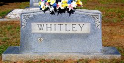
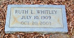
Ruth Laney Whitley
| Birth | : | 10 Jul 1909 Union County, North Carolina, USA |
| Death | : | 20 Oct 2003 Union County, North Carolina, USA |
| Burial | : | Mount Carmel United Methodist Church Cemetery, Mosheim, Greene County, USA |
| Coordinate | : | 36.2508210, -82.9526230 |
| Description | : | W/O ROY F. WHITLEY |
frequently asked questions (FAQ):
-
Where is Ruth Laney Whitley's memorial?
Ruth Laney Whitley's memorial is located at: Mount Carmel United Methodist Church Cemetery, Mosheim, Greene County, USA.
-
When did Ruth Laney Whitley death?
Ruth Laney Whitley death on 20 Oct 2003 in Union County, North Carolina, USA
-
Where are the coordinates of the Ruth Laney Whitley's memorial?
Latitude: 36.2508210
Longitude: -82.9526230
Family Members:
Parent
Spouse

Siblings


Children

Flowers:


Nearby Cemetories:
1. Mount Carmel United Methodist Church Cemetery
Mosheim, Greene County, USA
Coordinate: 36.2508210, -82.9526230
2. Carters Chapel United Methodist Church Cemetery
Greene County, USA
Coordinate: 36.2452800, -82.9224610
3. Mount Sinai United Methodist Church Cemetery
Mosheim, Greene County, USA
Coordinate: 36.2405260, -82.9829440
4. Brotherton Cemetery
Greene County, USA
Coordinate: 36.2789001, -82.9800034
5. Carters Station UMC Churchyard
Mosheim, Greene County, USA
Coordinate: 36.2410380, -82.9098200
6. Carters Station UMC Cemetery
Mosheim, Greene County, USA
Coordinate: 36.2395860, -82.9099840
7. Antioch United Methodist Church Cemetery
Mosheim, Greene County, USA
Coordinate: 36.2486040, -82.9983890
8. Pilot Knob Cemetery
Greene County, USA
Coordinate: 36.2711600, -82.9917500
9. Carter Family Cemetery
Greeneville, Greene County, USA
Coordinate: 36.2851390, -82.9241610
10. Starnes family cemetery
Romeo, Greene County, USA
Coordinate: 36.2911110, -82.9358330
11. Carpenter's Chapel Cemetery
Mosheim, Greene County, USA
Coordinate: 36.2200890, -82.9935800
12. Couch-Patterson Cemetery
Greene County, USA
Coordinate: 36.2971992, -82.9582977
13. Brown Springs Baptist Church Cemetery
Mosheim, Greene County, USA
Coordinate: 36.2032660, -82.9424770
14. Price Cemetery
Baileyton, Greene County, USA
Coordinate: 36.2919360, -82.9192790
15. Weems Chapel Cemetery
Mosheim, Greene County, USA
Coordinate: 36.2255760, -83.0091490
16. Everhart Cemetery
Greene County, USA
Coordinate: 36.3058014, -82.9431000
17. Ottway Bible Church Cemetery
Ottway, Greene County, USA
Coordinate: 36.2449610, -82.8812270
18. Short Road Civil War Burial Site
Bulls Gap, Hawkins County, USA
Coordinate: 36.2997400, -82.9959200
19. Brown Cemetery
Greene County, USA
Coordinate: 36.2522011, -83.0271988
20. Speedwell Missionary Baptist Church Cemetery
Bulls Gap, Hawkins County, USA
Coordinate: 36.2897400, -83.0096100
21. Mosheim Central Cemetery
Mosheim, Greene County, USA
Coordinate: 36.1906900, -82.9574800
22. Old Harmons Valley Cemetery
Mosheim, Greene County, USA
Coordinate: 36.2033005, -82.9991989
23. Blue Springs Cemetery
Mosheim, Greene County, USA
Coordinate: 36.1899500, -82.9580200
24. Harmons Valley United Methodist Church Cemetery
Mosheim, Greene County, USA
Coordinate: 36.2042656, -83.0018234