
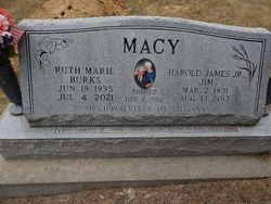


Ruth Marie Burks Macy
| Birth | : | 18 Jun 1935 Eskridge, Wabaunsee County, Kansas, USA |
| Death | : | 4 Jul 2021 Minneapolis, Ottawa County, Kansas, USA |
| Burial | : | Wesleyan Cemetery, Oak Hill, Clay County, USA |
| Coordinate | : | 39.2268982, -97.2572021 |
| Description | : | Ruth Marie (Burks) Macy was born near Eskridge, KS in Wabaunsee County Kansas on June 18, 1935. She was the youngest of four children born to Oliver and Grace (Burkepile} Burks. She went home to be with her Lord and Savior Jesus Christ on Sunday July 4, 2021, having reached the age of 86 years and 16 days. Ruth's family moved to Jewell County when she was a young girl. She graduated from Jewell High School in 1953. Following high school, she attended Miltonvale Wesleyan College where she met the love of her life, Jim Macy. They were... Read More |
frequently asked questions (FAQ):
-
Where is Ruth Marie Burks Macy's memorial?
Ruth Marie Burks Macy's memorial is located at: Wesleyan Cemetery, Oak Hill, Clay County, USA.
-
When did Ruth Marie Burks Macy death?
Ruth Marie Burks Macy death on 4 Jul 2021 in Minneapolis, Ottawa County, Kansas, USA
-
Where are the coordinates of the Ruth Marie Burks Macy's memorial?
Latitude: 39.2268982
Longitude: -97.2572021
Family Members:
Flowers:


Nearby Cemetories:
1. Wesleyan Cemetery
Oak Hill, Clay County, USA
Coordinate: 39.2268982, -97.2572021
2. Pleasant Valley Cemetery
Oak Hill, Clay County, USA
Coordinate: 39.2468987, -97.2889023
3. Rose Meron Cemetery
Oak Hill, Clay County, USA
Coordinate: 39.2194700, -97.3338900
4. Pleasant Ridge Cemetery
Clay County, USA
Coordinate: 39.2789001, -97.1841965
5. Athelstane Cemetery
Athelstane Township, Clay County, USA
Coordinate: 39.1768990, -97.1753006
6. Table Mound Cemetery
Idana, Clay County, USA
Coordinate: 39.3141300, -97.2792300
7. Hebron Cemetery
Clay County, USA
Coordinate: 39.3213800, -97.2601400
8. Zion Lutheran Cemetery
Clay County, USA
Coordinate: 39.2928009, -97.1557999
9. Mizpah Cemetery
Clay County, USA
Coordinate: 39.2057800, -97.1238500
10. Keystone Cemetery
Manchester, Dickinson County, USA
Coordinate: 39.1185989, -97.2917023
11. Swartwood Cemetery
Longford, Clay County, USA
Coordinate: 39.1323200, -97.3431500
12. Shields Cemetery
Clay County, USA
Coordinate: 39.3208008, -97.3507996
13. Uniondale Cemetery
Wakefield, Clay County, USA
Coordinate: 39.2382800, -97.0918400
14. Idana Cemetery
Idana, Clay County, USA
Coordinate: 39.3574500, -97.2693300
15. Republican City Cemetery
Clay Center, Clay County, USA
Coordinate: 39.3431015, -97.1628036
16. Greenridge Cemetery
Dickinson County, USA
Coordinate: 39.1199989, -97.1433029
17. Mount Liberty Church Cemetery
Ottawa County, USA
Coordinate: 39.2489400, -97.4356200
18. Saint John's Episcopal Cemetery
Clay County, USA
Coordinate: 39.2193985, -97.0744019
19. Henry Cemetery
Buckeye, Dickinson County, USA
Coordinate: 39.0828018, -97.1857986
20. Milo Chapman Gravesite
Broughton, Clay County, USA
Coordinate: 39.2888500, -97.0724400
21. Gilbert Cemetery
Clay County, USA
Coordinate: 39.2853012, -97.0625000
22. Wilson Cemetery
Clay County, USA
Coordinate: 39.3800011, -97.1896973
23. Vine Creek Cemetery
Ottawa County, USA
Coordinate: 39.1194000, -97.4180984
24. White Cloud Cemetery
Manchester, Dickinson County, USA
Coordinate: 39.0744019, -97.3525009