
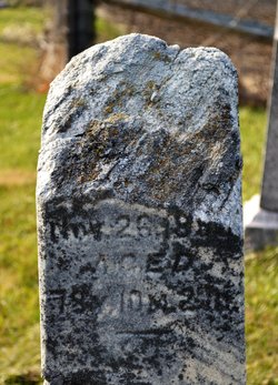
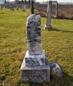
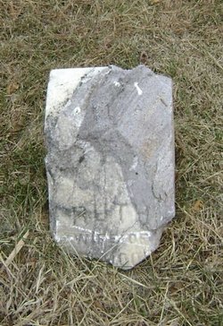
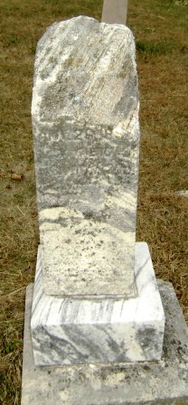

Ruth Wood Moore
| Birth | : | 29 Dec 1820 |
| Death | : | 26 Nov 1899 Tipton County, Indiana, USA |
| Burial | : | Liberty Cemetery, Folsomdale, Graves County, USA |
| Coordinate | : | 36.8917007, -88.6838989 |
| Inscription | : | Mother |
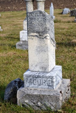
| Description | : | The daughter of Ashbury and Margaret (Miller) Woods. Ruth was born in either Henry or Wayne county, Indiana, and, on June 12, 1846, she married James Johnson Moore. |
frequently asked questions (FAQ):
-
Where is Ruth Wood Moore's memorial?
Ruth Wood Moore's memorial is located at: Liberty Cemetery, Folsomdale, Graves County, USA.
-
When did Ruth Wood Moore death?
Ruth Wood Moore death on 26 Nov 1899 in Tipton County, Indiana, USA
-
Where are the coordinates of the Ruth Wood Moore's memorial?
Latitude: 36.8917007
Longitude: -88.6838989
Family Members:
Parent
Spouse
Siblings
Children

Flowers:


Nearby Cemetories:
1. Liberty Cemetery
Folsomdale, Graves County, USA
Coordinate: 36.8917007, -88.6838989
2. Hocker-Russell Cemetery
Graves County, USA
Coordinate: 36.8934444, -88.7064440
3. Nall Cemetery
Folsomdale, Graves County, USA
Coordinate: 36.9109170, -88.6733330
4. Mason Fristoe Family Cemetery
Folsomdale, Graves County, USA
Coordinate: 36.9204722, -88.6983060
5. Kansas Cemetery
Kansas, Graves County, USA
Coordinate: 36.9037220, -88.7284720
6. McNeill Cemetery
Graves County, USA
Coordinate: 36.9139470, -88.6457220
7. McNeil Cemetery
McCracken County, USA
Coordinate: 36.9136009, -88.6453018
8. Johnson Cemetery
Boaz, Graves County, USA
Coordinate: 36.8993988, -88.6283035
9. Armistead Cemetery
Graves County, USA
Coordinate: 36.8903008, -88.7433014
10. Salem Cemetery
Boaz, Graves County, USA
Coordinate: 36.8669014, -88.6278000
11. Paschall Cemetery
Lowes, Graves County, USA
Coordinate: 36.8747300, -88.7462200
12. Pottsville Cemetery
Pottsville, Graves County, USA
Coordinate: 36.8517500, -88.7289870
13. Heard Cemetery
Graves County, USA
Coordinate: 36.9122009, -88.7474976
14. Allcock Cemetery
Mayfield, Graves County, USA
Coordinate: 36.9233017, -88.7399979
15. Straub Cemetery
McCracken County, USA
Coordinate: 36.9432983, -88.6539001
16. Pleasant Grove Baptist Church Cemetery
Mayfield, Graves County, USA
Coordinate: 36.8404000, -88.7178000
17. Mount Pisgah Cemetery
Boaz, Graves County, USA
Coordinate: 36.8842200, -88.6086600
18. Colliers Cemetery
Saint Johns, McCracken County, USA
Coordinate: 36.9536300, -88.6789920
19. Mount Pleasant Cemetery
Boaz, Graves County, USA
Coordinate: 36.9248795, -88.6161303
20. Woodlawn Memorial Gardens
Paducah, McCracken County, USA
Coordinate: 36.9585991, -88.6744003
21. New Concord Baptist Church Cemetery
Melber, Graves County, USA
Coordinate: 36.9312700, -88.7553900
22. Gore Cemetery
Saint Johns, McCracken County, USA
Coordinate: 36.9479710, -88.6274400
23. Johnson Cemetery
McCracken County, USA
Coordinate: 36.9618988, -88.6624985
24. Houser Grove Church of Christ Cemetery
Paducah, McCracken County, USA
Coordinate: 36.9567833, -88.6445618