
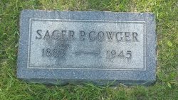
Sager Pearl “Jim” Cowger
| Birth | : | 4 Apr 1883 York, York County, Nebraska, USA |
| Death | : | 3 Jun 1943 Hill County, Montana, USA |
| Burial | : | Highland Cemetery, Havre, Hill County, USA |
| Coordinate | : | 48.5463982, -109.6900024 |
| Plot | : | Block 20 Lot 17 Space B |
| Description | : | Havre Daily News (MT), 7 June 1943 Services for Sager P. Cowger Held Sunday Services for Sager P. Cowger, known to a host of north Montana friends as Jim Cowger, who died at Havre June 3, were conducted at the Holland and Bonine chapel Sunday afternoon with Rev. Lyman W. Winkle of the Presbyterian church officiating. Mr. Cowger was born in York, Nebraska, April 4, 1883, and was the son of John Cowger and Mary Hattel Cowger. His early life was spent at Lincoln and Omaha, Neb., where he was engaged in the insurance business. He was united in marriage... Read More |
frequently asked questions (FAQ):
-
Where is Sager Pearl “Jim” Cowger's memorial?
Sager Pearl “Jim” Cowger's memorial is located at: Highland Cemetery, Havre, Hill County, USA.
-
When did Sager Pearl “Jim” Cowger death?
Sager Pearl “Jim” Cowger death on 3 Jun 1943 in Hill County, Montana, USA
-
Where are the coordinates of the Sager Pearl “Jim” Cowger's memorial?
Latitude: 48.5463982
Longitude: -109.6900024
Family Members:
Parent
Spouse
Siblings
Children

Flowers:


Nearby Cemetories:
1. Highland Cemetery
Havre, Hill County, USA
Coordinate: 48.5463982, -109.6900024
2. Calvary Cemetery
Havre, Hill County, USA
Coordinate: 48.5457000, -109.6883000
3. Mount Hope Cemetery
Havre, Hill County, USA
Coordinate: 48.5540000, -109.7050000
4. Sunset Garden Park
Havre, Hill County, USA
Coordinate: 48.5531006, -109.8019028
5. North Havre Lutheran Church Graveyard (Defunct)
Havre, Hill County, USA
Coordinate: 48.6538903, -109.6815870
6. Grainbelt Cemetery
Hill County, USA
Coordinate: 48.6828003, -109.8657990
7. Andrew S. Lohman Grave Site
Lohman, Blaine County, USA
Coordinate: 48.5903520, -109.4073350
8. East End Colony Cemetery
East End Colony, Hill County, USA
Coordinate: 48.7485000, -109.5474000
9. Hilldale Hutterite Colony Cemetery
Hilldale Colony, Hill County, USA
Coordinate: 48.7997000, -109.7872000
10. Saint Johns Catholic Cemetery
Havre, Hill County, USA
Coordinate: 48.7625008, -109.9638977
11. Saint Gabriel Cemetery
Chinook, Blaine County, USA
Coordinate: 48.6065200, -109.2531200
12. Kuper Memorial Cemetery
Chinook, Blaine County, USA
Coordinate: 48.6083100, -109.2531200
13. Rocky Boy Cemetery
Rocky Boy, Hill County, USA
Coordinate: 48.2572410, -109.7923690
14. Box Elder Cemetery
Box Elder, Hill County, USA
Coordinate: 48.3274000, -110.0095000
15. Rocky Boy Gravel Cemetery
Rocky Boy, Hill County, USA
Coordinate: 48.2427720, -109.7596500
16. Cottonwood Lutheran Church Cemetery
Havre, Hill County, USA
Coordinate: 48.4545000, -110.1748000
17. Bear Paw Battlefield
Chinook, Blaine County, USA
Coordinate: 48.3780070, -109.2121290
18. Hungry Hollow Cemetery
Blaine County, USA
Coordinate: 48.2103004, -109.4677963
19. Milk River Valley Church Graveyard
Hill County, USA
Coordinate: 48.6787180, -110.2261080
20. Hollandville Cemetery
Chinook, Blaine County, USA
Coordinate: 48.6960310, -109.1557200
21. Gildford Hill County Cemetery
Gildford, Hill County, USA
Coordinate: 48.5778008, -110.2957993
22. Prairie Chapel United Brethren Cemetery
Chinook, Blaine County, USA
Coordinate: 48.8860000, -109.3414000
23. Mennonite Brethren Cemetery
Chinook, Blaine County, USA
Coordinate: 48.8012560, -109.1980620
24. Bethel Bruderthaler Mennonite Church Cemetery
Chinook, Blaine County, USA
Coordinate: 48.7552000, -109.1345000