
| Birth | : | 1836 Yancey County, North Carolina, USA |
| Death | : | 1873 |
| Burial | : | Penrhys Cemetery, Wales |
| Coordinate | : | 51.6420500, -3.4425800 |
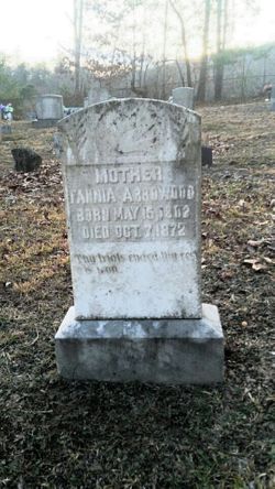
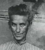
| Description | : | ********************************************************* Samuel was the son of John Arrowood and Frances "Fannia" Barnett. He was the eighth child born out of at least 13 children. He married Sarah Ellen "Ellender" Winters on April 21, 1858 in Yancey County, North Carolina. In the Census of 1860, Samuel was listed as a head of household in Yancey County, NC. He was listed as a neighbor of John Arrowood. In the Census of 1870, Samuel was listed as a head of household in Roan Mountain, Carter County, TN. Samuel rests under a fieldstone marker on a farm in Johnson City, Washington Co. Tennessee (formerly... Read More |
frequently asked questions (FAQ):
-
Where is Samuel Augustus Arrowood's memorial?
Samuel Augustus Arrowood's memorial is located at: Penrhys Cemetery, Wales.
-
When did Samuel Augustus Arrowood death?
Samuel Augustus Arrowood death on 1873 in
-
Where are the coordinates of the Samuel Augustus Arrowood's memorial?
Latitude: 51.6420500
Longitude: -3.4425800
Family Members:
Parent

Spouse
Siblings
Children
Flowers:


Nearby Cemetories:
1. Penrhys Cemetery
Wales
Coordinate: 51.6420500, -3.4425800
2. Holy Trinity Churchyard
Ilfracombe, North Devon District, England
Coordinate: 51.5571712, -3.5946496
3. Newcastle St. Illtyd Churchyard
Wales
Coordinate: 51.5080900, -3.5829600
4. St George's Churchyard
Wales
Coordinate: 51.4819300, -3.2911700
5. St Nicholas Church
Wales
Coordinate: 51.4605000, -3.3098000
6. Twyn yr Odyn Baptist Chapel Burial Ground
Wales
Coordinate: 51.4563708, -3.2739268
7. Saint David's Churchyard
Wales
Coordinate: 51.8017440, -3.6967650
8. St. Peter's Churchyard
Wales
Coordinate: 51.6133800, -3.0590490
9. St David Church Burial Ground
Wales
Coordinate: 51.7703100, -3.7884600
10. Godre'r Graig Independent Chapel Cemetery
Wales
Coordinate: 51.7474400, -3.8089300
11. Alltwen Welsh Congregational Chapelyard
Wales
Coordinate: 51.7139600, -3.8444700
12. St Elli’s Churchyard
Wales
Coordinate: 51.8264420, -3.1154820
13. Rhyd-Y-Fro Saron Congregational Old Chapelyard
Wales
Coordinate: 51.7379400, -3.8662700
14. St. Peter's Churchyard
Wales
Coordinate: 51.7364689, -2.9735286
15. St. Cadoc
Wales
Coordinate: 51.7818400, -2.9716800
16. Three Crosses Churchyard, Capel y Crwys
Wales
Coordinate: 51.6278387, -4.0653017
17. St. John the Baptist Churchyard
Weston-super-Mare, North Somerset Unitary Authority, England
Coordinate: 51.3523010, -2.9813260
18. Saint Pauls Churchyard
Kewstoke, North Somerset Unitary Authority, England
Coordinate: 51.3655500, -2.9568900
19. St Paul's Churchyard
Kewstoke, North Somerset Unitary Authority, England
Coordinate: 51.3655390, -2.9566120
20. Clevedon Cemetery
Clevedon, North Somerset Unitary Authority, England
Coordinate: 51.4322600, -2.8747270
21. St Andrew Churchyard
Clevedon, North Somerset Unitary Authority, England
Coordinate: 51.4331670, -2.8735760
22. Weston-Super-Mare Cemetery
Weston-super-Mare, North Somerset Unitary Authority, England
Coordinate: 51.3541300, -2.9676900
23. Llandingat Parish Church
Wales
Coordinate: 51.9914392, -3.8022458
24. Weston-super-Mare Emmanuel Churchyard
Weston-super-Mare, North Somerset Unitary Authority, England
Coordinate: 51.3458940, -2.9773860