
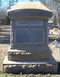
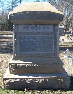
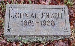
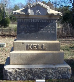
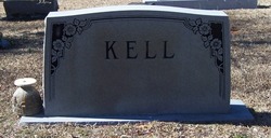
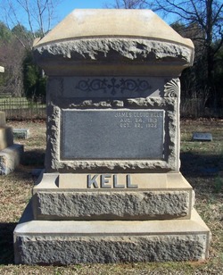
Samuel Hicklin Kell Sr.
| Birth | : | 24 Apr 1869 Mecklenburg County, North Carolina, USA |
| Death | : | 5 Mar 1931 Mecklenburg County, North Carolina, USA |
| Burial | : | Banks Presbyterian Church Cemetery, Marvin, Union County, USA |
| Coordinate | : | 34.9930305, -80.8189697 |
frequently asked questions (FAQ):
-
Where is Samuel Hicklin Kell Sr.'s memorial?
Samuel Hicklin Kell Sr.'s memorial is located at: Banks Presbyterian Church Cemetery, Marvin, Union County, USA.
-
When did Samuel Hicklin Kell Sr. death?
Samuel Hicklin Kell Sr. death on 5 Mar 1931 in Mecklenburg County, North Carolina, USA
-
Where are the coordinates of the Samuel Hicklin Kell Sr.'s memorial?
Latitude: 34.9930305
Longitude: -80.8189697
Family Members:
Parent

Spouse

Siblings


Children

Flowers:


Nearby Cemetories:
1. Banks Presbyterian Church Cemetery
Marvin, Union County, USA
Coordinate: 34.9930305, -80.8189697
2. Marvin United Methodist Church Cemetery
Marvin, Union County, USA
Coordinate: 34.9928894, -80.8166580
3. Marvin AME Zion Church Cemetery
Waxhaw, Union County, USA
Coordinate: 34.9920000, -80.8040000
4. Pleasant Valley Baptist Church Cemetery
Lancaster County, USA
Coordinate: 34.9931793, -80.8495407
5. Old Elbethel AME Zion Church Cemetery
Indian Land, Lancaster County, USA
Coordinate: 34.9631250, -80.8125350
6. Elbethel AME Zion Church Cemetery
Belair, Lancaster County, USA
Coordinate: 34.9626270, -80.8299860
7. Independent Bible Baptist Church Cemetery
Charlotte, Mecklenburg County, USA
Coordinate: 35.0179990, -80.8488210
8. Pleasant Hill United Methodist Church Cemetery
Indian Land, Lancaster County, USA
Coordinate: 35.0006960, -80.8620870
9. Silver Hill Cemetery
Indian Land, Lancaster County, USA
Coordinate: 35.0149280, -80.8557590
10. Silver Run Cemetery
Lancaster County, USA
Coordinate: 35.0149994, -80.8561020
11. Saint Margarets Episcopal Church
Waxhaw, Union County, USA
Coordinate: 35.0104310, -80.7781500
12. Edwards Cemetery
Indian Land, Lancaster County, USA
Coordinate: 34.9770010, -80.8607570
13. Higher Ground Church Cemetery
Indian Land, Lancaster County, USA
Coordinate: 34.9713300, -80.8597020
14. Bonds Grove United Methodist Church Cemetery
Waxhaw, Union County, USA
Coordinate: 34.9739609, -80.7715378
15. Old Six Mile Cemetery
Indian Land, Lancaster County, USA
Coordinate: 34.9484250, -80.8220320
16. Belair Methodist Church Cemetery
Lancaster County, USA
Coordinate: 34.9509964, -80.8433228
17. Redding Springs AME Zion Church Cemetery
Union County, USA
Coordinate: 34.9911919, -80.7594910
18. Weddington United Methodist Church Cemetery
Weddington, Union County, USA
Coordinate: 35.0212288, -80.7618332
19. Harrison United Methodist Church Cemetery
Pineville, Mecklenburg County, USA
Coordinate: 35.0415450, -80.8637550
20. Big Pineville AME Zion Church and Cemetery
Pineville, Mecklenburg County, USA
Coordinate: 35.0466280, -80.8562640
21. Indian Hill AME Zion Church Cemetery
Indian Land, Lancaster County, USA
Coordinate: 35.0318830, -80.8775660
22. Indian Land Baptist Church Cemetery
Indian Land, Lancaster County, USA
Coordinate: 34.9318840, -80.8367260
23. Six Mile Cemetery
Indian Land, Lancaster County, USA
Coordinate: 34.9308014, -80.8319016
24. Price Chapel Baptist Church Cemetery
Waxhaw, Union County, USA
Coordinate: 34.9415283, -80.7617188