
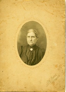


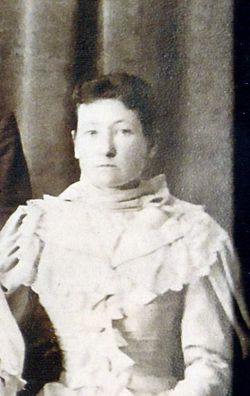
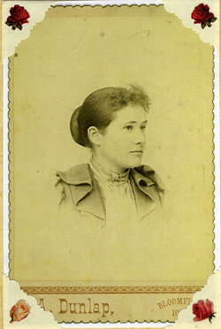
Sarah Elizabeth Dunn Dunlavy
| Birth | : | 2 Sep 1851 Davis County, Iowa, USA |
| Death | : | 29 Jul 1921 Iowa, USA |
| Burial | : | St. James' Churchyard, Anston, Metropolitan Borough of Rotherham, England |
| Coordinate | : | 53.3476690, -1.2208800 |
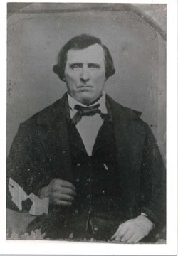
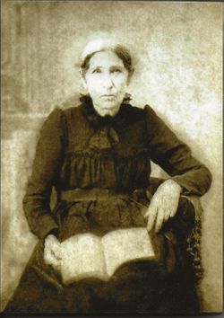
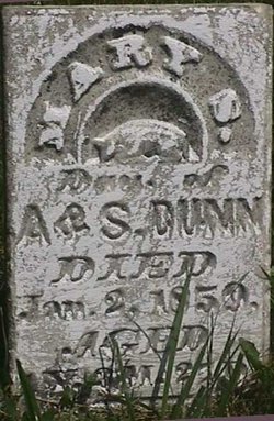
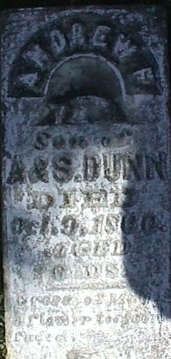
| Description | : | Sarah was born and died in Dunville, Davis County, Iowa. She was the wife of John Wesley Dunlavy and mother of 12 children. Daughter of Andrew and Sarah (Miller) Dunn. From "The Miller Family, A History and Genealogy of the Decendants of Jacob Miller Born In Germany" by Charles Philander Miller 1932. "Elizabeth and John Dunlavy lived together almost 52 1/2 years and were never apart over ten days. They were buried at Dunnville in one grave." {note: Above notation Courtesy of William Bacon} |
frequently asked questions (FAQ):
-
Where is Sarah Elizabeth Dunn Dunlavy's memorial?
Sarah Elizabeth Dunn Dunlavy's memorial is located at: St. James' Churchyard, Anston, Metropolitan Borough of Rotherham, England.
-
When did Sarah Elizabeth Dunn Dunlavy death?
Sarah Elizabeth Dunn Dunlavy death on 29 Jul 1921 in Iowa, USA
-
Where are the coordinates of the Sarah Elizabeth Dunn Dunlavy's memorial?
Latitude: 53.3476690
Longitude: -1.2208800
Family Members:
Parent
Spouse

Siblings

Children
Flowers:


Nearby Cemetories:
1. St. James' Churchyard
Anston, Metropolitan Borough of Rotherham, England
Coordinate: 53.3476690, -1.2208800
2. Anston Burial Ground
Anston, Metropolitan Borough of Rotherham, England
Coordinate: 53.3452140, -1.2139500
3. Park Avenue Cemetery
Dinnington St John's, Metropolitan Borough of Rotherham, England
Coordinate: 53.3633710, -1.2100700
4. St. Peter and St. Paul's Churchyard
Todwick, Metropolitan Borough of Rotherham, England
Coordinate: 53.3514144, -1.2540578
5. St. Peter's Churchyard
Thorpe Salvin, Metropolitan Borough of Rotherham, England
Coordinate: 53.3247920, -1.2200350
6. Dinnington Church Cemetery
Dinnington St John's, Metropolitan Borough of Rotherham, England
Coordinate: 53.3699557, -1.2117994
7. St. George's Churchyard
Woodsetts, Metropolitan Borough of Rotherham, England
Coordinate: 53.3476000, -1.1729800
8. All Hallows Churchyard
Harthill, Metropolitan Borough of Rotherham, England
Coordinate: 53.3232800, -1.2604170
9. St John's Church Cemetery
Dinnington St John's, Metropolitan Borough of Rotherham, England
Coordinate: 53.3818248, -1.2135210
10. St John's Churchyard
Throapham, Metropolitan Borough of Rotherham, England
Coordinate: 53.3823850, -1.2147036
11. St. John The Baptist Churchyard
Rotherham, Metropolitan Borough of Rotherham, England
Coordinate: 53.3391500, -1.2842450
12. St. John the Baptist Churchyard
Wales, Metropolitan Borough of Rotherham, England
Coordinate: 53.3389540, -1.2843530
13. St. John the Baptist Church Cemetery
Wales, Metropolitan Borough of Rotherham, England
Coordinate: 53.3365267, -1.2841334
14. All Saints Churchyard
Laughton-en-le-Morthen, Metropolitan Borough of Rotherham, England
Coordinate: 53.3882454, -1.2243221
15. Thurcroft Cemetery
Thurcroft, Metropolitan Borough of Rotherham, England
Coordinate: 53.3862010, -1.2525060
16. St. Peter's Churchyard
Letwell, Metropolitan Borough of Rotherham, England
Coordinate: 53.3773774, -1.1606489
17. All Saints Churchyard
Aston, Metropolitan Borough of Rotherham, England
Coordinate: 53.3621450, -1.2978130
18. All Saints Church
Sheffield, Metropolitan Borough of Sheffield, England
Coordinate: 53.3618734, -1.2981901
19. All Saints Chapel
Bolsover District, England
Coordinate: 53.3027370, -1.1859097
20. Aston-Cum-Aughton Cemetery
Aston, Metropolitan Borough of Rotherham, England
Coordinate: 53.3644400, -1.2991600
21. St. Simon & St. Jude Churchyard
Thurcroft, Metropolitan Borough of Rotherham, England
Coordinate: 53.3943010, -1.2552430
22. St. Martin Churchyard
Firbeck, Metropolitan Borough of Rotherham, England
Coordinate: 53.3900080, -1.1561770
23. Killamarsh Cemetery
Killamarsh, North East Derbyshire District, England
Coordinate: 53.3231700, -1.3081400
24. St. Giles Parish Church
Killamarsh, North East Derbyshire District, England
Coordinate: 53.3236200, -1.3092600