
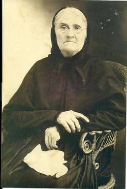
| Birth | : | 11 Mar 1862 North Carolina, USA |
| Death | : | 1 Sep 1957 Pilot Mountain, Surry County, North Carolina, USA |
| Burial | : | Pilot Mountain City Cemetery, Pilot Mountain, Surry County, USA |
| Coordinate | : | 36.3918343, -80.4809418 |
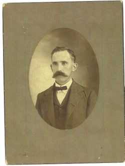
| Description | : | 95yrs 5mos 20days. Daughter of Johnathon Preston and Frances McDaniel Bullington. Wife of Jesse Allen Venable, who she married on April 1, 1883 in Surry Co., North Carolina. (Note: Family shown in the 1910 census for Surry Co., Pilot twp., Pilot Mountain town as follows: Jesse A. Venable--50; Sarah F.--48; children--Edgar L.--23; Louella--21; Rosa B.--19; Winston C.--17; Ada F.--15; Minnie A.--13; Hessie J.??--11; Howard L.--9; Mollie M.--7; and Dovie J.--5. Next door was James W. Venable--25, probably their oldest son with a wife, Mary C. Venable--17.) |
frequently asked questions (FAQ):
-
Where is Sarah Frances Bullington Venable's memorial?
Sarah Frances Bullington Venable's memorial is located at: Pilot Mountain City Cemetery, Pilot Mountain, Surry County, USA.
-
When did Sarah Frances Bullington Venable death?
Sarah Frances Bullington Venable death on 1 Sep 1957 in Pilot Mountain, Surry County, North Carolina, USA
-
Where are the coordinates of the Sarah Frances Bullington Venable's memorial?
Latitude: 36.3918343
Longitude: -80.4809418
Family Members:
Parent
Spouse

Siblings
Children
Flowers:


Nearby Cemetories:
1. Pilot Mountain City Cemetery
Pilot Mountain, Surry County, USA
Coordinate: 36.3918343, -80.4809418
2. Green Family Cemetery
Pilot Mountain, Surry County, USA
Coordinate: 36.3956630, -80.4833990
3. Lovells Chapel Church Cemetery
Pilot Mountain, Surry County, USA
Coordinate: 36.3879160, -80.4652290
4. Tucker-Stone Cemetery
Surry County, USA
Coordinate: 36.3990000, -80.4954167
5. Bennett Cemetery
Pilot Mountain, Surry County, USA
Coordinate: 36.3988991, -80.4957962
6. Rescue Baptist Church Cemetery
Pilot Mountain, Surry County, USA
Coordinate: 36.3898080, -80.4613240
7. Beulahland Baptist Church Cemetery
Pilot Mountain, Surry County, USA
Coordinate: 36.4037330, -80.4954900
8. John Denny Cemetery
Pilot Mountain, Surry County, USA
Coordinate: 36.3755989, -80.4910965
9. John Wesley Hill Cemetery
Pilot Mountain, Surry County, USA
Coordinate: 36.4000282, -80.5012817
10. Stone Family Cemetery
Pilot Mountain, Surry County, USA
Coordinate: 36.3695070, -80.4689960
11. Friendly Chapel Church Cemetery
Pilot Mountain, Surry County, USA
Coordinate: 36.3635292, -80.4816132
12. Whitakers Chapel United Methodist Church Cemetery
Pilot Mountain, Surry County, USA
Coordinate: 36.3763008, -80.5105057
13. Sulphur Springs Baptist Church Cemetery
Pilot Mountain, Surry County, USA
Coordinate: 36.4074440, -80.5108871
14. Lawrence Cemetery
Pilot Mountain, Surry County, USA
Coordinate: 36.3716080, -80.4537230
15. Hills Presbyterian Church Cemetery
Hills Grove, Surry County, USA
Coordinate: 36.4234161, -80.4621658
16. Captain Bill Wilson Family Cemetery
Brims Grove, Stokes County, USA
Coordinate: 36.4168750, -80.4405590
17. Worth Cemetery
Ararat, Surry County, USA
Coordinate: 36.4180130, -80.5205710
18. Jessup Family Cemetery
Pilot Mountain, Surry County, USA
Coordinate: 36.4282990, -80.4563980
19. McDaniel Family Cemetery
Pilot Mountain, Surry County, USA
Coordinate: 36.4285800, -80.4560500
20. Carey Bird Denny Cemetery
Pilot Mountain, Surry County, USA
Coordinate: 36.3582000, -80.5177500
21. Hills Village Family Cemetery
Hills Grove, Surry County, USA
Coordinate: 36.4352200, -80.4594500
22. Ararat-Cedar Hill Primitive Baptist Church
Cedar Hill, Surry County, USA
Coordinate: 36.3671265, -80.5306778
23. Cox Cemetery
Pilot Mountain, Surry County, USA
Coordinate: 36.3743890, -80.5353890
24. Brim Family Cemetery
Stokes County, USA
Coordinate: 36.4026952, -80.4201749