
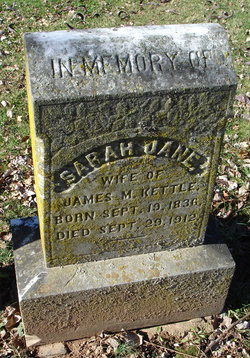
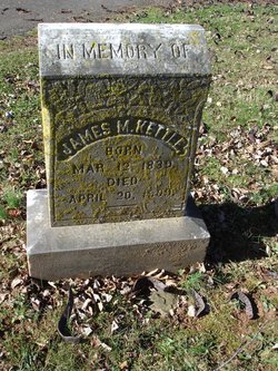
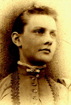
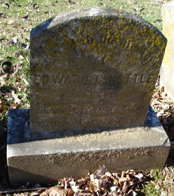
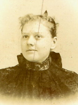
Sarah Jane Donohoe Kettle
| Birth | : | 19 Sep 1836 Loudoun County, Virginia, USA |
| Death | : | 29 Sep 1912 |
| Burial | : | Peterson Village Cemetery, Peterson, Lewis County, USA |
| Coordinate | : | 38.8938270, -80.5400510 |
| Plot | : | A Lot 160 Site 5 |
| Description | : | Sarah Jane and James were married 20 Feb 1873 in Loudoun County, Virginia. They had four children. |
frequently asked questions (FAQ):
-
Where is Sarah Jane Donohoe Kettle's memorial?
Sarah Jane Donohoe Kettle's memorial is located at: Peterson Village Cemetery, Peterson, Lewis County, USA.
-
When did Sarah Jane Donohoe Kettle death?
Sarah Jane Donohoe Kettle death on 29 Sep 1912 in
-
Where are the coordinates of the Sarah Jane Donohoe Kettle's memorial?
Latitude: 38.8938270
Longitude: -80.5400510
Family Members:
Parent
Spouse
Siblings

Children
Flowers:


Nearby Cemetories:
1. Peterson Village Cemetery
Peterson, Lewis County, USA
Coordinate: 38.8938270, -80.5400510
2. Jacksonville Cemetery
Weston, Lewis County, USA
Coordinate: 38.8919890, -80.4935740
3. Saint Bridget's Church Cemetery
Weston, Lewis County, USA
Coordinate: 38.9319400, -80.5572970
4. Clover Fork Cemetery
Orlando, Lewis County, USA
Coordinate: 38.8583500, -80.5774260
5. Hall Family Cemetery
Walkersville, Lewis County, USA
Coordinate: 38.8702470, -80.4852440
6. Swecker Cemetery
Roanoke, Lewis County, USA
Coordinate: 38.9428950, -80.5282380
7. Hannah Temple Cemetery
Walkersville, Lewis County, USA
Coordinate: 38.8800610, -80.4736130
8. Rittenhouse Cemetery
Walkersville, Lewis County, USA
Coordinate: 38.8812700, -80.4730520
9. Simons Cemetery
Walkersville, Lewis County, USA
Coordinate: 38.8806490, -80.4731390
10. Chop Fork Cemetery
Chapman, Braxton County, USA
Coordinate: 38.8391991, -80.5428009
11. Heater Cemetery
Burnsville, Braxton County, USA
Coordinate: 38.9024560, -80.6100370
12. Fairview Cemetery
Roanoke, Lewis County, USA
Coordinate: 38.9306000, -80.4847000
13. Whitesell Cemetery
Lewis County, USA
Coordinate: 38.9307760, -80.4844406
14. Finster Chapel Cemetery
Peterson, Lewis County, USA
Coordinate: 38.9300003, -80.5999985
15. William L. Smith Cemetery
Roanoke, Lewis County, USA
Coordinate: 38.9228820, -80.4715130
16. Dennison Family Cemetery
Walkersville, Lewis County, USA
Coordinate: 38.8932350, -80.4616670
17. Long Point Cemetery
Walkersville, Lewis County, USA
Coordinate: 38.8718987, -80.4666977
18. Riffles Run Cemetery
Burnsville, Braxton County, USA
Coordinate: 38.8474900, -80.5944100
19. Paul T Mitchell Cemetery
Roanoke, Lewis County, USA
Coordinate: 38.9437210, -80.4905340
20. Briar Point Cemetery
Walkersville, Lewis County, USA
Coordinate: 38.9438170, -80.4905950
21. Casto Cemetery
Knawl, Braxton County, USA
Coordinate: 38.8292020, -80.5163670
22. Knawls Creek Cemetery
Knawl, Braxton County, USA
Coordinate: 38.8299100, -80.5035330
23. Oak Grove Cemetery
Lewis County, USA
Coordinate: 38.9641390, -80.5326100
24. Pumphrey Cemetery
Orlando, Lewis County, USA
Coordinate: 38.9275880, -80.6216500