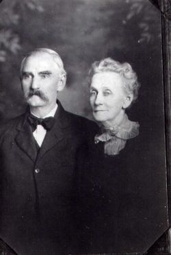
| Birth | : | 23 Dec 1822 Poland Center, Mahoning County, Ohio, USA |
| Death | : | 15 Apr 1888 Hiawatha, Brown County, Kansas, USA |
| Burial | : | Hiawatha Cemetery, Hiawatha, Brown County, USA |
| Coordinate | : | 39.8601799, -95.5265198 |
| Description | : | Wife of Rolla Peckinpaugh 1811-1859. Sarah moved to Rulo Nebraska in 1872, later to Brown County Kansas, where she lived with her son Isaac, and near her oldest son Robert and family, and daughter Rebecca Peckinpaugh Dilley and family, until her death. She came to Putnam County Ohio in 1836 with her parents Robert and Rebecca Stewart Lowry, early pioneers of this area. Sarah Jane was first married to James Irvin in 1838, but he died the following year. She then married Rolla Peckinpaugh 25 August 1842. BROWN COUNTY WORLD HIAWATHA, KANSAS 20 April 1888 Sarah J. Peckinpaugh, aged 65 years, died Sunday from a... Read More |
frequently asked questions (FAQ):
-
Where is Sarah Jane Lowry Peckinpaugh's memorial?
Sarah Jane Lowry Peckinpaugh's memorial is located at: Hiawatha Cemetery, Hiawatha, Brown County, USA.
-
When did Sarah Jane Lowry Peckinpaugh death?
Sarah Jane Lowry Peckinpaugh death on 15 Apr 1888 in Hiawatha, Brown County, Kansas, USA
-
Where are the coordinates of the Sarah Jane Lowry Peckinpaugh's memorial?
Latitude: 39.8601799
Longitude: -95.5265198
Family Members:
Parent
Spouse
Siblings
Children
Flowers:
Nearby Cemetories:
1. Hiawatha Cemetery
Hiawatha, Brown County, USA
Coordinate: 39.8601799, -95.5265198
2. Mount Hope Cemetery
Hiawatha, Brown County, USA
Coordinate: 39.8497009, -95.5156021
3. Bemis Cemetery
Hiawatha, Brown County, USA
Coordinate: 39.8194900, -95.5668300
4. Niles Cemetery
Hiawatha, Brown County, USA
Coordinate: 39.8730900, -95.6126300
5. Oakland Cemetery
Padonia, Brown County, USA
Coordinate: 39.9273900, -95.5610900
6. Claytonville Cemetery
Horton, Brown County, USA
Coordinate: 39.7766991, -95.5046997
7. Ununda Cemetery
Robinson, Brown County, USA
Coordinate: 39.8582993, -95.4143982
8. Shelton Cemetery
Hamlin, Brown County, USA
Coordinate: 39.8852997, -95.6393967
9. Hart Cemetery
Reserve, Brown County, USA
Coordinate: 39.9519005, -95.5366974
10. Carson Cemetery
Hamlin, Brown County, USA
Coordinate: 39.8810200, -95.6483100
11. Hamlin Cemetery
Hamlin, Brown County, USA
Coordinate: 39.9206009, -95.6292877
12. Rose Hill Cemetery
Robinson, Brown County, USA
Coordinate: 39.8097000, -95.4139023
13. Pleasant Hill Cemetery
Irving Township, Brown County, USA
Coordinate: 39.9435997, -95.4328232
14. Kenyon Cemetery
Robinson, Brown County, USA
Coordinate: 39.9122000, -95.3964600
15. Pleasant Hill Cemetery
Fairview, Brown County, USA
Coordinate: 39.8411800, -95.6716400
16. Saint Paul Lutheran Cemetery
Fairview, Brown County, USA
Coordinate: 39.8559700, -95.6779700
17. Cornelison Cemetery
Reserve, Brown County, USA
Coordinate: 39.9754105, -95.5485687
18. Madison Cemetery
Robinson, Brown County, USA
Coordinate: 39.7717700, -95.4201700
19. Powhattan Cemetery
Powhattan, Brown County, USA
Coordinate: 39.7681007, -95.6288986
20. Immanuel Lutheran Cemetery
Fairview, Brown County, USA
Coordinate: 39.8559700, -95.6858500
21. Laus Creek Cemetery
Reserve, Brown County, USA
Coordinate: 39.9754105, -95.4699936
22. Pleasant Hill Cemetery
Hamlin, Brown County, USA
Coordinate: 39.9430428, -95.6484299
23. Sun Springs Cemetery
Morrill, Brown County, USA
Coordinate: 39.8993988, -95.6836014
24. Old Fairview Cemetery
Fairview, Brown County, USA
Coordinate: 39.8550491, -95.6948700


