
| Birth | : | 11 Nov 1854 Missouri, USA |
| Death | : | 12 Sep 1921 Council Bluffs, Pottawattamie County, Iowa, USA |
| Burial | : | Malvern Cemetery, Malvern, Mills County, USA |
| Coordinate | : | 40.9886017, -95.5785980 |
| Plot | : | Section 12 Lot 560 |
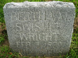
| Description | : | Sarah married Samuel Bonham on December 25, 1876 in Malvern Iowa. Sarah and Samuel are the parents of: ~Amos Cheney b. July 22, 1877 d. May 26, 1959 ~Bertha Mable b. February 5, 1879 d. July 5, 1928 ~Roy Elmer b. June 17, 1884 d. February 26, 1955 ~Angeline b. February 17, 1886 d. August 2, 1958 ~Lulu Blanche b. August 21, 1897 d. September 15, 1973 |
frequently asked questions (FAQ):
-
Where is Sarah Riley Johnson Bonham's memorial?
Sarah Riley Johnson Bonham's memorial is located at: Malvern Cemetery, Malvern, Mills County, USA.
-
When did Sarah Riley Johnson Bonham death?
Sarah Riley Johnson Bonham death on 12 Sep 1921 in Council Bluffs, Pottawattamie County, Iowa, USA
-
Where are the coordinates of the Sarah Riley Johnson Bonham's memorial?
Latitude: 40.9886017
Longitude: -95.5785980
Family Members:
Parent

Spouse
Siblings
Children
Flowers:


Nearby Cemetories:
1. Malvern Cemetery
Malvern, Mills County, USA
Coordinate: 40.9886017, -95.5785980
2. Parker Cemetery
White Cloud, Mills County, USA
Coordinate: 40.9737649, -95.5184363
3. Hillsdale Cemetery
Glenwood, Mills County, USA
Coordinate: 41.0097008, -95.6427994
4. Wearin Cemetery
Malvern, Mills County, USA
Coordinate: 41.0395000, -95.5313000
5. Hastings Cemetery
Hastings, Mills County, USA
Coordinate: 41.0097008, -95.4993973
6. South Grove Cemetery
Mills County, USA
Coordinate: 40.9775009, -95.4931030
7. East Liberty Cemetery
Malvern, Mills County, USA
Coordinate: 41.0592346, -95.6005020
8. Fairview Cemetery
Tabor, Mills County, USA
Coordinate: 40.9453011, -95.6716995
9. Mills County Farm Cemetery
Glenwood, Mills County, USA
Coordinate: 41.0417930, -95.6756530
10. North Grove Cemetery
Hastings, Mills County, USA
Coordinate: 41.0161018, -95.4618988
11. Bomar Family Cemetery
Mills County, USA
Coordinate: 41.0369400, -95.6941700
12. Cotten Cemetery
Mills County, USA
Coordinate: 41.0845000, -95.5167000
13. Estes Cemetery
Tabor, Mills County, USA
Coordinate: 40.9425011, -95.7080994
14. Randolph Cemetery
Randolph, Fremont County, USA
Coordinate: 40.8769493, -95.5695038
15. Tabor Cemetery
Tabor, Mills County, USA
Coordinate: 40.9035260, -95.6799460
16. Riverside Cemetery
Randolph, Fremont County, USA
Coordinate: 40.8806000, -95.5269012
17. Pottawattamie Chief Waubonsie Burial Site
Mills County, USA
Coordinate: 40.9236100, -95.7086100
18. Waubonsie Cemetery
Mills County, USA
Coordinate: 40.9451370, -95.7310791
19. Silver City Cemetery
Silver City, Mills County, USA
Coordinate: 41.1042442, -95.6380005
20. Glenwood Resource Center Cemetery
Glenwood, Mills County, USA
Coordinate: 41.0361720, -95.7338590
21. Wesley Chapel Cemetery
Henderson, Mills County, USA
Coordinate: 41.1019249, -95.4987793
22. Rhodes Cemetery
Tabor, Fremont County, USA
Coordinate: 40.9011002, -95.7097015
23. Saylers Farm Cemetery
Henderson, Mills County, USA
Coordinate: 41.1083300, -95.4919440
24. Emerson Cemetery
Emerson, Mills County, USA
Coordinate: 41.0325012, -95.4021988