
| Birth | : | Aug 1865 New York, USA |
| Death | : | 1949 |
| Burial | : | Finedon, Finedon, Wellingborough Borough, England |
| Coordinate | : | 52.3407999, -0.6648562 |
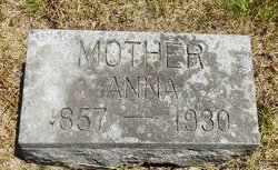
| Description | : | Sarah ("Sadie") is the wife of George Edward Burns. |
frequently asked questions (FAQ):
-
Where is Sarah “Sadie” Law Burns's memorial?
Sarah “Sadie” Law Burns's memorial is located at: Finedon, Finedon, Wellingborough Borough, England.
-
When did Sarah “Sadie” Law Burns death?
Sarah “Sadie” Law Burns death on 1949 in
-
Where are the coordinates of the Sarah “Sadie” Law Burns's memorial?
Latitude: 52.3407999
Longitude: -0.6648562
Family Members:
Parent

Spouse
Siblings
Children
Flowers:


Nearby Cemetories:
1. Finedon
Finedon, Wellingborough Borough, England
Coordinate: 52.3407999, -0.6648562
2. Saint Mary the Virgin Churchyard Extension
Finedon, Wellingborough Borough, England
Coordinate: 52.3385489, -0.6613748
3. Burton Latimer Cemetery
Burton Latimer, Kettering Borough, England
Coordinate: 52.3642100, -0.6733200
4. Baptist Church
Burton Latimer, Kettering Borough, England
Coordinate: 52.3642183, -0.6773429
5. Burton Latimer Parish Council Cemetery
Burton Latimer, Kettering Borough, England
Coordinate: 52.3649700, -0.6738600
6. St Mary the Virgin
Burton Latimer, Kettering Borough, England
Coordinate: 52.3659000, -0.6751170
7. Saint Peter
Isham, Wellingborough Borough, England
Coordinate: 52.3563320, -0.7021160
8. All Saints Churchyard
Great Harrowden, Wellingborough Borough, England
Coordinate: 52.3286800, -0.7096600
9. Isham Cemetery
Isham, Wellingborough Borough, England
Coordinate: 52.3597000, -0.7056800
10. New Irthlingborough Cemetery
Irthlingborough, East Northamptonshire Borough, England
Coordinate: 52.3178531, -0.6294229
11. St Mary the Virgin
Little Harrowden, Wellingborough Borough, England
Coordinate: 52.3362282, -0.7223209
12. St Peter's Churchyard
Irthlingborough, East Northamptonshire Borough, England
Coordinate: 52.3251642, -0.6101925
13. All Saints Churchyard
Wellingborough, Wellingborough Borough, England
Coordinate: 52.3010890, -0.6879730
14. All Hallows Churchyard
Wellingborough Borough, England
Coordinate: 52.3024740, -0.6937430
15. London Road Cemetery
Wellingborough, Wellingborough Borough, England
Coordinate: 52.2986000, -0.6878000
16. St. Mary's Churchyard
Orlingbury, Wellingborough Borough, England
Coordinate: 52.3426000, -0.7397000
17. St. John's Churchyard
Cranford St John, Kettering Borough, England
Coordinate: 52.3840560, -0.6391670
18. St. Andrew's Churchyard
Cranford, Kettering Borough, England
Coordinate: 52.3856700, -0.6438700
19. St Botolph Churchyard
Barton Seagrave, Kettering Borough, England
Coordinate: 52.3846400, -0.6961900
20. All Saints Churchyard
Great Addington, East Northamptonshire Borough, England
Coordinate: 52.3657660, -0.5937010
21. Doddington Road Cemetery
Wellingborough, Wellingborough Borough, England
Coordinate: 52.2942380, -0.6956600
22. All Saints Churchyard
Pytchley, Kettering Borough, England
Coordinate: 52.3641220, -0.7384500
23. Higham Ferrers Cemetery
Higham Ferrers, East Northamptonshire Borough, England
Coordinate: 52.3084850, -0.5945270
24. St. Mary the Virgin Churchyard
Higham Ferrers, East Northamptonshire Borough, England
Coordinate: 52.3065500, -0.5915240