

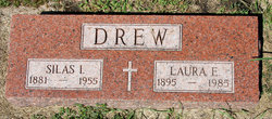
Silas Ira Drew
| Birth | : | 20 Jan 1881 Palo Alto County, Iowa, USA |
| Death | : | 8 Dec 1955 Emmetsburg, Palo Alto County, Iowa, USA |
| Burial | : | Bethel Baptist Church Cemetery, Chambers County, USA |
| Coordinate | : | 33.0872002, -85.3463974 |
frequently asked questions (FAQ):
-
Where is Silas Ira Drew's memorial?
Silas Ira Drew's memorial is located at: Bethel Baptist Church Cemetery, Chambers County, USA.
-
When did Silas Ira Drew death?
Silas Ira Drew death on 8 Dec 1955 in Emmetsburg, Palo Alto County, Iowa, USA
-
Where are the coordinates of the Silas Ira Drew's memorial?
Latitude: 33.0872002
Longitude: -85.3463974
Family Members:
Parent
Spouse
Siblings

Children
Flowers:


Nearby Cemetories:
1. Bethel Baptist Church Cemetery
Chambers County, USA
Coordinate: 33.0872002, -85.3463974
2. Skyview Memorial Garden
Five Points, Chambers County, USA
Coordinate: 33.0731010, -85.3368988
3. Mount Pisgah Primitive Baptist Cemetery
Stroud, Chambers County, USA
Coordinate: 33.0661011, -85.3337021
4. Littlefield Cemetery
Stroud, Chambers County, USA
Coordinate: 33.0853930, -85.3176780
5. Lanes Chapel Methodist Church Cemetery
Roanoke, Randolph County, USA
Coordinate: 33.1129210, -85.3645760
6. Stephens Family Cemetery
Stroud, Chambers County, USA
Coordinate: 33.0767600, -85.3129300
7. Antioch Christian Church Cemetery
Doublehead, Chambers County, USA
Coordinate: 33.0963330, -85.3916360
8. Sanders Cemetery
Chambers County, USA
Coordinate: 33.0558014, -85.3771973
9. Old Union Methodist Church Cemetery
Five Points, Chambers County, USA
Coordinate: 33.0437810, -85.3397370
10. Peace and Goodwill Baptist Church Cemetery
Randolph County, USA
Coordinate: 33.1240270, -85.3954800
11. Higgins Family Cemetery
Chambers County, USA
Coordinate: 33.0475006, -85.3933029
12. Rehope Baptist Church Cemetery
Chambers County, USA
Coordinate: 33.0573690, -85.4029200
13. East Roanoke Cemetery
Roanoke, Randolph County, USA
Coordinate: 33.1432991, -85.3644028
14. Old Salem Primitive Baptist Cemetery
Bacon Level, Randolph County, USA
Coordinate: 33.1375200, -85.3103400
15. Finney Cemetery
Five Points, Chambers County, USA
Coordinate: 33.0311012, -85.3692017
16. Mount Bethel United Methodist Church Cemetery
Roanoke, Randolph County, USA
Coordinate: 33.1281290, -85.3992600
17. Booger Hill Cemetery
Roanoke, Randolph County, USA
Coordinate: 33.1481018, -85.3610992
18. Sweet Home Baptist Church Cemetery
Chambers County, USA
Coordinate: 33.0358900, -85.3035370
19. Fellowship Baptist Church Cemetery
Bacon Level, Randolph County, USA
Coordinate: 33.1270650, -85.2868900
20. Five Points Belcher Cemetery
Chambers County, USA
Coordinate: 33.0212390, -85.3542120
21. Old Five Points Cemetery
Five Points, Chambers County, USA
Coordinate: 33.0205910, -85.3485430
22. Cedarwood Cemetery
Roanoke, Randolph County, USA
Coordinate: 33.1519012, -85.3681030
23. Roanoke Baptist Church Cemetery
Roanoke, Randolph County, USA
Coordinate: 33.1506600, -85.3730260
24. Pleasant Hill Baptist Church Cemetery
Milltown, Chambers County, USA
Coordinate: 33.0865070, -85.4332090