
Solomon Allred I
| Birth | : | 2 Nov 1680 Lancashire, England |
| Death | : | 1754 Randolph County, North Carolina, USA |
| Burial | : | Sandy Creek Baptist Church Cemetery, Liberty, Randolph County, USA |
| Coordinate | : | 35.8235550, -79.6429050 |
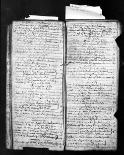
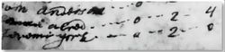
| Description | : | Solomon ALLRED I is the son of John ALLRED and his wife Ellen PEMBERTON of Eccles, Lancashire, England. Image posted of Solomon ALLRED I, Baptism, 2 Nov 1680, Ecceles Parish, St. Mary, Lancashire, England per parish records. (See image of Parish Record of the Baptism of Solomon Allred to the left) It was my privilege to work with and exchange many Emails with the delightful professional Allred Family Researcher Dawnell H Griffin for several years during her research in preparation of her book. Dawnell honored me as a "kindred spirit" in York and Alldred family genealogy. Dawnell helped me... Read More |
frequently asked questions (FAQ):
-
Where is Solomon Allred I's memorial?
Solomon Allred I's memorial is located at: Sandy Creek Baptist Church Cemetery, Liberty, Randolph County, USA.
-
When did Solomon Allred I death?
Solomon Allred I death on 1754 in Randolph County, North Carolina, USA
-
Where are the coordinates of the Solomon Allred I's memorial?
Latitude: 35.8235550
Longitude: -79.6429050
Family Members:
Parent
Spouse

Siblings
Children
Flowers:

Left by Anonymous on 24 Nov 2016

Rest in Peace
Left by Anonymous on 18 Mar 2016

Left by Anonymous on 21 Dec 2016

Left by Anonymous on 08 Aug 2019

Left by Anonymous on 09 Aug 2019

Left by Anonymous on 08 Mar 2020

Left by Anonymous on 01 Jan 2021

Left by Anonymous on 29 Jun 2021

Left by Anonymous on 05 Dec 2021


Nearby Cemetories:
1. Sandy Creek Baptist Church Cemetery
Liberty, Randolph County, USA
Coordinate: 35.8235550, -79.6429050
2. Sandy Creek Primitive Baptist Church Cemetery
Liberty, Randolph County, USA
Coordinate: 35.8239020, -79.6406560
3. Melanchthon Lutheran Church Cemetery
Liberty, Randolph County, USA
Coordinate: 35.8451630, -79.6440640
4. Cool Springs Baptist Church Cemetery
Franklinville, Randolph County, USA
Coordinate: 35.8072420, -79.6805660
5. McMasters Cemetery
Randolph County, USA
Coordinate: 35.8072370, -79.6021500
6. Whites Chapel United Methodist Church Cemetery
Liberty, Randolph County, USA
Coordinate: 35.7850520, -79.6422990
7. Bethany United Methodist Church Cemetery #2
Liberty, Randolph County, USA
Coordinate: 35.8430060, -79.5948160
8. Grays Chapel Cemetery
Grays Chapel, Randolph County, USA
Coordinate: 35.8183570, -79.6986060
9. Patterson Grove Christian Church Cemetery
Ramseur, Randolph County, USA
Coordinate: 35.7743940, -79.6536550
10. Hollys Chapel Pentecostal Holiness Church
Ramseur, Randolph County, USA
Coordinate: 35.7825600, -79.6048200
11. Mount Pleasant Baptist Church Cemetery
Staley, Randolph County, USA
Coordinate: 35.8144700, -79.5790000
12. Saint Stephen Memorial Gardens
Liberty, Randolph County, USA
Coordinate: 35.8550750, -79.5877970
13. Amos Grove Cemetery
Liberty, Randolph County, USA
Coordinate: 35.8546982, -79.5871964
14. Fairview Cemetery
Liberty, Randolph County, USA
Coordinate: 35.8516998, -79.5761032
15. Shady Grove Baptist Church Cemetery
Staley, Randolph County, USA
Coordinate: 35.7853800, -79.5821020
16. Margarets Chapel Church Cemetery
Staley, Randolph County, USA
Coordinate: 35.8110940, -79.5648900
17. Whites Memorial Baptist Church Cemetery
Franklinville, Randolph County, USA
Coordinate: 35.7939680, -79.7149760
18. Red Cross Baptist Church Cemetery
Redcross, Randolph County, USA
Coordinate: 35.8715591, -79.6995850
19. Lineberry Family Cemetery
Staley, Randolph County, USA
Coordinate: 35.7878000, -79.5724000
20. Old Shady Grove Cemetery
Staley, Randolph County, USA
Coordinate: 35.7874985, -79.5725021
21. York Family Cemetery
Ramseur, Randolph County, USA
Coordinate: 35.7603000, -79.6108000
22. Olivers Chapel Cemetery
Staley, Randolph County, USA
Coordinate: 35.8060989, -79.5610962
23. Shiloh United Methodist Church Cemetery
Liberty, Randolph County, USA
Coordinate: 35.8915430, -79.6594990
24. Bethel United Methodist Church Cemetery
Randolph County, USA
Coordinate: 35.8779190, -79.7051540