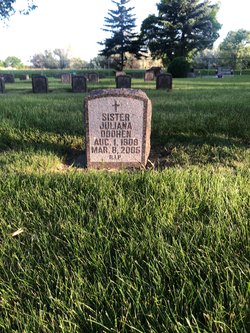
Sr Juliana Doohen
| Birth | : | 1 Aug 1909 Burbank, Clay County, South Dakota, USA |
| Death | : | 8 Mar 2005 Aberdeen, Brown County, South Dakota, USA |
| Burial | : | St. Paul Churchyard, Caton, City of Lancaster, England |
| Coordinate | : | 54.0757840, -2.7009980 |
| Description | : | Aberdeen - Sister Juliana Doohen, 95, a Sister of the Presentation of the Blessed Virgin Mary, died March 8, 2005, at Mother Joseph Manor. The funeral for Sister Juliana will be Friday, March 11, 2005, at 10 a.m., in Blessed Sacrament Chapel at Presentation Convent, Aberdeen, S.D. Father Ben Benzinger, SJ, will be celebrant and homilist. A Scripture Rosary Service will be Thursday, March 10 at 7 p.m. in the Blessed Sacrament Chapel. Visitation will be from 4 to 7 p.m. Burial will be at the Sacred Heart Cemetery with Spitzer Funeral Home, 320 Sixth Avenue S.E., in charge of... Read More |
frequently asked questions (FAQ):
-
Where is Sr Juliana Doohen's memorial?
Sr Juliana Doohen's memorial is located at: St. Paul Churchyard, Caton, City of Lancaster, England.
-
When did Sr Juliana Doohen death?
Sr Juliana Doohen death on 8 Mar 2005 in Aberdeen, Brown County, South Dakota, USA
-
Where are the coordinates of the Sr Juliana Doohen's memorial?
Latitude: 54.0757840
Longitude: -2.7009980
Family Members:
Parent
Siblings
Flowers:
Nearby Cemetories:
1. St. Paul Churchyard
Caton, City of Lancaster, England
Coordinate: 54.0757840, -2.7009980
2. St. Chad's Churchyard
Claughton, City of Lancaster, England
Coordinate: 54.0931310, -2.6643990
3. St. Saviour's Church
Halton, City of Lancaster, England
Coordinate: 54.1025610, -2.6891750
4. St Wilfrid's Churchyard
Halton, City of Lancaster, England
Coordinate: 54.0759400, -2.7672600
5. St Peter's Churchyard
Quernmore, City of Lancaster, England
Coordinate: 54.0367200, -2.7375400
6. Nether Kellet Congregational Church
Nether Kellet, City of Lancaster, England
Coordinate: 54.1070772, -2.7587630
7. St Cuthbert Churchyard
Over Kellet, City of Lancaster, England
Coordinate: 54.1195480, -2.7318200
8. Lancaster Cemetery
Lancaster, City of Lancaster, England
Coordinate: 54.0504210, -2.7768760
9. St. Margaret's Churchyard
Hornby, City of Lancaster, England
Coordinate: 54.1114000, -2.6362000
10. St. Wilfred Priory
Hornby, City of Lancaster, England
Coordinate: 54.1143640, -2.6405490
11. Quernmore Methodist Churchyard
Quernmore, City of Lancaster, England
Coordinate: 54.0259440, -2.7361400
12. St. John The Evangelist Churchyard
Gressingham, City of Lancaster, England
Coordinate: 54.1233910, -2.6557800
13. Skerton Cemetery
Lancaster, City of Lancaster, England
Coordinate: 54.0651430, -2.7951140
14. Slyne Cemetery
Slyne, City of Lancaster, England
Coordinate: 54.0868185, -2.7969423
15. Carnforth Cemetery
Carnforth, City of Lancaster, England
Coordinate: 54.1245420, -2.7587820
16. Holy Trinity Churchyard
Bolton-le-Sands, City of Lancaster, England
Coordinate: 54.1027700, -2.7911700
17. Christ Church United Reform Church
Bolton-le-Sands, City of Lancaster, England
Coordinate: 54.1015860, -2.7929000
18. Saint Luke's Parish Churchyard
Skerton, City of Lancaster, England
Coordinate: 54.0564700, -2.7982600
19. Holy Trinity Churchyard
Wray, City of Lancaster, England
Coordinate: 54.1022960, -2.6081510
20. Cathedral Cemetery of Lancaster
Lancaster, City of Lancaster, England
Coordinate: 54.0471170, -2.7942920
21. St. John the Evangelist Churchyard
Lancaster, City of Lancaster, England
Coordinate: 54.0504000, -2.7990000
22. St. Nicholas Street Chapel Churchyard
Lancaster, City of Lancaster, England
Coordinate: 54.0486900, -2.7987900
23. Mount Street Congregational Chapel
Lancaster, City of Lancaster, England
Coordinate: 54.0468260, -2.8027430
24. Lancaster Castle Cemetery
Lancaster, City of Lancaster, England
Coordinate: 54.0494330, -2.8047890


