

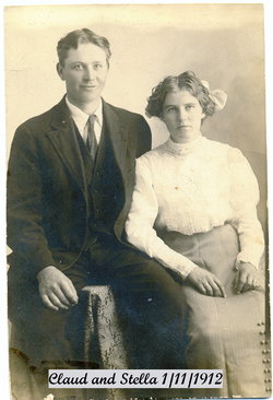

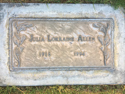
Stella Blanch Simpson Allen
| Birth | : | 16 Apr 1895 Red Lodge, Carbon County, Montana, USA |
| Death | : | 29 Jun 1993 Bakersfield, Kern County, California, USA |
| Burial | : | Hillcrest Memorial Park, Bakersfield, Kern County, USA |
| Coordinate | : | 35.3814316, -118.9012527 |
frequently asked questions (FAQ):
-
Where is Stella Blanch Simpson Allen's memorial?
Stella Blanch Simpson Allen's memorial is located at: Hillcrest Memorial Park, Bakersfield, Kern County, USA.
-
When did Stella Blanch Simpson Allen death?
Stella Blanch Simpson Allen death on 29 Jun 1993 in Bakersfield, Kern County, California, USA
-
Where are the coordinates of the Stella Blanch Simpson Allen's memorial?
Latitude: 35.3814316
Longitude: -118.9012527
Family Members:
Parent
Spouse
Siblings
Children
Flowers:


Nearby Cemetories:
1. Hillcrest Memorial Park
Bakersfield, Kern County, USA
Coordinate: 35.3814316, -118.9012527
2. Kuntz Ranch Cemetery
Bakersfield, Kern County, USA
Coordinate: 35.4373560, -118.9390180
3. Greenlawn Cemetery and Mortuary
Bakersfield, Kern County, USA
Coordinate: 35.4067001, -118.9856033
4. Union Cemetery
Bakersfield, Kern County, USA
Coordinate: 35.3646500, -118.9948700
5. Home of Peace Jewish Cemetery
Bakersfield, Kern County, USA
Coordinate: 35.3631500, -118.9987400
6. Saint Pauls Episcopal Church Columbarium
Bakersfield, Kern County, USA
Coordinate: 35.3746120, -119.0277940
7. Chinese Cemetery
Bakersfield, Kern County, USA
Coordinate: 35.3510550, -119.0273380
8. Greenlawn Southwest Mortuary and Cemetery
Bakersfield, Kern County, USA
Coordinate: 35.2948990, -119.0330810
9. Arvin Cemetery
Arvin, Kern County, USA
Coordinate: 35.2132300, -118.8952700
10. Long Tom Mine Cemetery
Woody, Kern County, USA
Coordinate: 35.5495600, -118.8308700
11. Bakersfield National Cemetery
Arvin, Kern County, USA
Coordinate: 35.2559600, -118.6693480
12. Engle Family Cemetery
Bakersfield, Kern County, USA
Coordinate: 35.6392060, -118.9231180
13. Shafter Memorial Park
Shafter, Kern County, USA
Coordinate: 35.4728012, -119.2341995
14. Rankin Cemetery
Walker Basin, Kern County, USA
Coordinate: 35.3844560, -118.5388890
15. Fickert Family Cemetery
Bear Valley Springs, Kern County, USA
Coordinate: 35.1697260, -118.6443350
16. Cesar E. Chavez National Monument
Keene, Kern County, USA
Coordinate: 35.2236000, -118.5592400
17. Weringer Cemetery
Woody, Kern County, USA
Coordinate: 35.7062100, -118.8320800
18. Blue Mountain Cemetery
Woody, Kern County, USA
Coordinate: 35.7065500, -118.8322400
19. Saint Joseph Cemetery
Havilah, Kern County, USA
Coordinate: 35.5147500, -118.5177700
20. Williams Burial Site
Walker Basin, Kern County, USA
Coordinate: 35.4320950, -118.4815680
21. Pomfret Memorial Cemetery
Famoso, Kern County, USA
Coordinate: 35.6313580, -119.2064460
22. Tehachapi Cove Cemetery
Tehachapi, Kern County, USA
Coordinate: 35.1190000, -118.5724600
23. Paris-Loraine Cemetery
Loraine, Kern County, USA
Coordinate: 35.3059000, -118.4355000
24. Oak Grove Cemetery
Glennville, Kern County, USA
Coordinate: 35.7414017, -118.7157974