
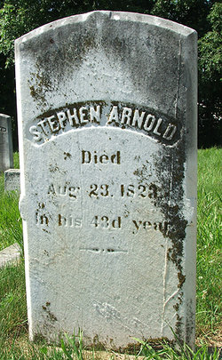
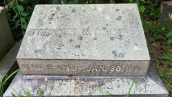
Stephen Arnold
| Birth | : | 4 Jun 1781 Warwick, Kent County, Rhode Island, USA |
| Death | : | 23 Aug 1823 Warwick, Kent County, Rhode Island, USA |
| Burial | : | Pishill Parish Church Cemetery, Pishill, South Oxfordshire District, England |
| Coordinate | : | 51.6027550, -0.9527530 |
| Plot | : | P-5 |
| Inscription | : | STEPHEN ARNOLD DIED AUG. 23, 1823 IN HIS 43d YEAR |
| Description | : | * * * * * * Died at 43 Years of Age Parents: Benedict & Lydia (Weaver) Arnold |
frequently asked questions (FAQ):
-
Where is Stephen Arnold's memorial?
Stephen Arnold's memorial is located at: Pishill Parish Church Cemetery, Pishill, South Oxfordshire District, England.
-
When did Stephen Arnold death?
Stephen Arnold death on 23 Aug 1823 in Warwick, Kent County, Rhode Island, USA
-
Where are the coordinates of the Stephen Arnold's memorial?
Latitude: 51.6027550
Longitude: -0.9527530
Family Members:
Parent
Spouse
Siblings
Children
Flowers:


Nearby Cemetories:
1. Pishill Parish Church Cemetery
Pishill, South Oxfordshire District, England
Coordinate: 51.6027550, -0.9527530
2. Stonor Park Cemetery
Henley-on-Thames, South Oxfordshire District, England
Coordinate: 51.5967370, -0.9289660
3. St. James' Old Churchyard
South Oxfordshire District, England
Coordinate: 51.5769360, -0.9532550
4. St Nicholas Churchyard
Ibstone, Wycombe District, England
Coordinate: 51.6247660, -0.9093120
5. St. Mary the Virgin Churchyard
Fawley, Wycombe District, England
Coordinate: 51.5743000, -0.9140000
6. St. Bartholomew's Churchyard
Nettlebed, South Oxfordshire District, England
Coordinate: 51.5752360, -0.9936230
7. St Mary's Churchyard
Turville, Wycombe District, England
Coordinate: 51.6139860, -0.8938190
8. St. Botolph Old Cemetery
Swyncombe, South Oxfordshire District, England
Coordinate: 51.6065347, -1.0157358
9. St. Botolph's New Graveyard
Swyncombe, South Oxfordshire District, England
Coordinate: 51.6064829, -1.0167999
10. St. James's Churchyard
Bix and Assendon, South Oxfordshire District, England
Coordinate: 51.5610070, -0.9511270
11. Getty Family Estate
Stokenchurch, Wycombe District, England
Coordinate: 51.6437360, -0.9334510
12. St. Bartholomew Churchyard
Fingest, Wycombe District, England
Coordinate: 51.6137200, -0.8791500
13. Henley-on-Thames Cemetery
Henley-on-Thames, South Oxfordshire District, England
Coordinate: 51.5543570, -0.9271320
14. Watlington War Memorial
Watlington, South Oxfordshire District, England
Coordinate: 51.6456450, -1.0065781
15. St. Pauls Highmoor Cross
Highmoor, South Oxfordshire District, England
Coordinate: 51.5532740, -0.9910110
16. Saint Mary the Virgin Churchyard
Hambleden, Wycombe District, England
Coordinate: 51.5773100, -0.8709500
17. Holy Trinity Churchyard
Nuffield, South Oxfordshire District, England
Coordinate: 51.5810040, -1.0378960
18. St. Mary-le-Moor Churchyard
Cadmore End, Wycombe District, England
Coordinate: 51.6263500, -0.8686600
19. St Nicholas Churchyard
Britwell Salome, South Oxfordshire District, England
Coordinate: 51.6376983, -1.0262075
20. St. Leonard's Churchyard
Watlington, South Oxfordshire District, England
Coordinate: 51.6474030, -1.0117420
21. All Saints Churchyard
Shirburn, South Oxfordshire District, England
Coordinate: 51.6577000, -0.9945000
22. St. John the Evangelist Churchyard
Hambleden, Wycombe District, England
Coordinate: 51.6052700, -0.8514000
23. St Mary Churchyard
Pyrton, South Oxfordshire District, England
Coordinate: 51.6558520, -1.0076830
24. Stokenchurch Church Cemetery
Stokenchurch, Wycombe District, England
Coordinate: 51.6572200, -0.8960300