

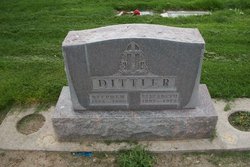
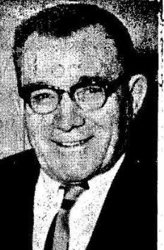
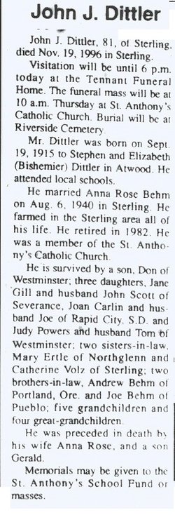
Stephen Dittler
| Birth | : | 18 Jan 1878 Russia |
| Death | : | 20 May 1962 Sterling, Logan County, Colorado, USA |
| Burial | : | Didcot Cemetery, Didcot, South Oxfordshire District, England |
| Coordinate | : | 51.6033500, -1.2438400 |
frequently asked questions (FAQ):
-
Where is Stephen Dittler's memorial?
Stephen Dittler's memorial is located at: Didcot Cemetery, Didcot, South Oxfordshire District, England.
-
When did Stephen Dittler death?
Stephen Dittler death on 20 May 1962 in Sterling, Logan County, Colorado, USA
-
Where are the coordinates of the Stephen Dittler's memorial?
Latitude: 51.6033500
Longitude: -1.2438400
Family Members:
Spouse
Children
Flowers:


Nearby Cemetories:
1. Didcot Cemetery
Didcot, South Oxfordshire District, England
Coordinate: 51.6033500, -1.2438400
2. All Saints Churchyard
Didcot, South Oxfordshire District, England
Coordinate: 51.6107791, -1.2508990
3. St Andrew Church Cemetery
East Hagbourne, South Oxfordshire District, England
Coordinate: 51.5912000, -1.2460500
4. St. Andrew Churchyard
East Hagbourne, South Oxfordshire District, England
Coordinate: 51.5902000, -1.2430000
5. St Andrew's Church
East Hagbourne, South Oxfordshire District, England
Coordinate: 51.5901700, -1.2427700
6. Harwell Cemetery
Harwell, Vale of White Horse District, England
Coordinate: 51.5985200, -1.2885900
7. Saint Matthews Churchyard
Harwell, Vale of White Horse District, England
Coordinate: 51.5983510, -1.2908880
8. All Saints Churchyard
North Moreton, South Oxfordshire District, England
Coordinate: 51.6021922, -1.1898247
9. St. Michael Churchyard
Blewbury, Vale of White Horse District, England
Coordinate: 51.5693100, -1.2346100
10. South Moreton Strict Baptist Chapel
South Moreton, South Oxfordshire District, England
Coordinate: 51.5900300, -1.1924310
11. St Michael Churchyard Extension
Blewbury, Vale of White Horse District, England
Coordinate: 51.5668100, -1.2429900
12. Ss. Peter and Paul Churchyard
Appleford, Vale of White Horse District, England
Coordinate: 51.6396800, -1.2356090
13. St. John the Baptist South Moreton
South Moreton, South Oxfordshire District, England
Coordinate: 51.5881630, -1.1895850
14. All Saints Churchyard
Aston Upthorpe, South Oxfordshire District, England
Coordinate: 51.5715900, -1.2037500
15. Sutton Courtenay Village Cemetery
Sutton Courtenay, Vale of White Horse District, England
Coordinate: 51.6394000, -1.2746000
16. St Michael's Cemetery
Aston Tirrold, South Oxfordshire District, England
Coordinate: 51.5730994, -1.1967145
17. St Blaise Churchyard
Milton, Vale of White Horse District, England
Coordinate: 51.6284810, -1.3003670
18. All Saints Churchyard
Sutton Courtenay, Vale of White Horse District, England
Coordinate: 51.6442680, -1.2718070
19. St Mary the Virgin Churchyard
Long Wittenham, South Oxfordshire District, England
Coordinate: 51.6423650, -1.2092860
20. St. Agatha New Churchyard
Brightwell cum Sotwell, South Oxfordshire District, England
Coordinate: 51.6131480, -1.1665480
21. St. Peter's Churchyard
Little Wittenham, South Oxfordshire District, England
Coordinate: 51.6369880, -1.1830625
22. St. Paul's Churchyard
Culham, South Oxfordshire District, England
Coordinate: 51.6512320, -1.2762060
23. Saint James Churchyard
Brightwell cum Sotwell, South Oxfordshire District, England
Coordinate: 51.6120200, -1.1549800
24. Drayton Burial Ground
Drayton, Vale of White Horse District, England
Coordinate: 51.6443618, -1.3055533