
| Birth | : | 14 Sep 1838 Washington County, Tennessee, USA |
| Death | : | 28 Mar 1921 Onawa, Monona County, Iowa, USA |
| Burial | : | Dean Road and Manor Road Cemetery, Scarborough, Scarborough Borough, England |
| Coordinate | : | 54.2843690, -0.4184140 |
| Plot | : | Section 1, Lot 12, Row 13 |
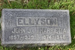
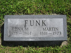
| Description | : | Additional information provided by Allen Ellyson, 8/16/2012 - "I am the 2X Great Grandson of John W. or R. Ellyson/Ellison/Ellisen and Susan A Brubaker Ellyson Funk. She was briefly married to my 2X Great Grandfather in 1856. He died shortly after that. I have not been able to find out how or why he died. My Great Grandfather John Joseph Ellyson was born in 1857. She then married John Funk in about 1858. Their Children are also Aunts and Uncles of mine. ....... I also have not been able to find John Ellyson's Parents in my search. ........ I have... Read More |
frequently asked questions (FAQ):
-
Where is Susannah A. “Susan” Brubaker Funk's memorial?
Susannah A. “Susan” Brubaker Funk's memorial is located at: Dean Road and Manor Road Cemetery, Scarborough, Scarborough Borough, England.
-
When did Susannah A. “Susan” Brubaker Funk death?
Susannah A. “Susan” Brubaker Funk death on 28 Mar 1921 in Onawa, Monona County, Iowa, USA
-
Where are the coordinates of the Susannah A. “Susan” Brubaker Funk's memorial?
Latitude: 54.2843690
Longitude: -0.4184140
Family Members:
Parent
Spouse

Siblings
Children
Flowers:


Nearby Cemetories:
1. Dean Road and Manor Road Cemetery
Scarborough, Scarborough Borough, England
Coordinate: 54.2843690, -0.4184140
2. Greyfriars Abbey
Scarborough, Scarborough Borough, England
Coordinate: 54.2850360, -0.3950300
3. Quaker House Church
Scarborough Borough, England
Coordinate: 54.2844280, -0.3941730
4. St. Mary's Churchyard
Scarborough, Scarborough Borough, England
Coordinate: 54.2864850, -0.3936260
5. Woodlands Cemetery and Crematorium
Scarborough, Scarborough Borough, England
Coordinate: 54.2766640, -0.4428030
6. Scarborough Castle
Scarborough, Scarborough Borough, England
Coordinate: 54.2875810, -0.3895485
7. St Laurence Churchyard
Scalby, Scarborough Borough, England
Coordinate: 54.2988160, -0.4507520
8. St. John the Baptist Churchyard
East Ayton, Scarborough Borough, England
Coordinate: 54.2508900, -0.4792900
9. St Martin Churchyard
Seamer, Scarborough Borough, England
Coordinate: 54.2361500, -0.4437100
10. Cloughton Church Cemetery
Cloughton, Scarborough Borough, England
Coordinate: 54.3322500, -0.4511900
11. St. John the Baptist Churchyard
Cayton, Scarborough Borough, England
Coordinate: 54.2346470, -0.3805180
12. St Peter Churchyard
Hackness, Scarborough Borough, England
Coordinate: 54.3012880, -0.5127850
13. Cayton Cemetery
Cayton, Scarborough Borough, England
Coordinate: 54.2314030, -0.3755910
14. St Matthew Churchyard
Hutton Buscel, Scarborough Borough, England
Coordinate: 54.2426410, -0.5071200
15. St. Helen’s & All Saints Churchyard
Wykeham, Scarborough Borough, England
Coordinate: 54.2372000, -0.5212000
16. St Peter Churchyard
Langdale End, Scarborough Borough, England
Coordinate: 54.3065050, -0.5557030
17. St John The Evangelist Churchyard
Folkton, Scarborough Borough, England
Coordinate: 54.2020400, -0.3865200
18. Flixton Cemetery New
Folkton, Scarborough Borough, England
Coordinate: 54.2006600, -0.3934700
19. St Margaret Churchyard
Harwood Dale, Scarborough Borough, England
Coordinate: 54.3470030, -0.5238540
20. St. Peter's Churchyard
Willerby, Ryedale District, England
Coordinate: 54.1984200, -0.4558500
21. Staintondale Churchyard
Staintondale, Scarborough Borough, England
Coordinate: 54.3752645, -0.4795295
22. All Saints Churchyard
Brompton-by-Sawdon, Scarborough Borough, England
Coordinate: 54.2262550, -0.5549320
23. All Saints Church Cemetery
Brompton-by-Sawdon, Scarborough Borough, England
Coordinate: 54.2223100, -0.5500900
24. St Margaret Churchyard (Ruins)
Harwood Dale, Scarborough Borough, England
Coordinate: 54.3558170, -0.5365790