
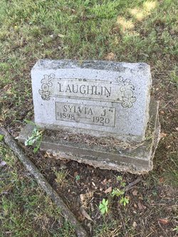
Sylvia J. Laughlin
| Birth | : | 13 Oct 1898 McDonald County, Missouri, USA |
| Death | : | 24 Mar 1920 Washburn, Barry County, Missouri, USA |
| Burial | : | Shaws Creek Methodist Campground Cemetery, Horse Shoe, Henderson County, USA |
| Coordinate | : | 35.3437996, -82.5345001 |
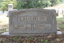
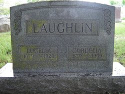
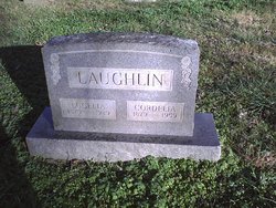
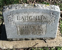
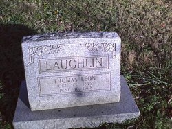
| Description | : | Daughter of Thomas C. Laughlin and Mary Ellen Bowles. Causeof death was pulmonary tuberculosis. She had never married. (Source: Missouri Death Certificate) |
frequently asked questions (FAQ):
-
Where is Sylvia J. Laughlin's memorial?
Sylvia J. Laughlin's memorial is located at: Shaws Creek Methodist Campground Cemetery, Horse Shoe, Henderson County, USA.
-
When did Sylvia J. Laughlin death?
Sylvia J. Laughlin death on 24 Mar 1920 in Washburn, Barry County, Missouri, USA
-
Where are the coordinates of the Sylvia J. Laughlin's memorial?
Latitude: 35.3437996
Longitude: -82.5345001
Family Members:
Parent

Siblings

Flowers:


Nearby Cemetories:
1. Shaws Creek Methodist Campground Cemetery
Horse Shoe, Henderson County, USA
Coordinate: 35.3437996, -82.5345001
2. Old French Broad Baptist Church
Rugby, Henderson County, USA
Coordinate: 35.3588340, -82.5418500
3. Jeremiah Osborne Cemetery
Horse Shoe, Henderson County, USA
Coordinate: 35.3527400, -82.5551720
4. Mill Pond Cemetery
Rugby, Henderson County, USA
Coordinate: 35.3666992, -82.5239029
5. McCarson Cemetery
Henderson County, USA
Coordinate: 35.3442001, -82.5021973
6. Henderson County Home Cemetery
Henderson County, USA
Coordinate: 35.3535480, -82.4986540
7. Shaws Creek Baptist Church Cemetery
Horse Shoe, Henderson County, USA
Coordinate: 35.3231010, -82.4983978
8. Beulah Baptist Church Cemetery
Henderson County, USA
Coordinate: 35.3041992, -82.5580978
9. McCrary Family Cemetery
Henderson County, USA
Coordinate: 35.3366776, -82.4810562
10. Shepherd Memorial Park
Naples, Henderson County, USA
Coordinate: 35.3835351, -82.5067129
11. Mills River Presbyterian Church Cemetery
Mills River, Henderson County, USA
Coordinate: 35.3777733, -82.5728073
12. First Congregational Church Memorial Garden
Hendersonville, Henderson County, USA
Coordinate: 35.3151530, -82.4841940
13. Grace Lutheran Church Memorial Garden
Hendersonville, Henderson County, USA
Coordinate: 35.3212100, -82.4786900
14. Saint Matthews Cemetery
Hillgirt, Henderson County, USA
Coordinate: 35.3683014, -82.4792023
15. Mills River United Methodist Church
Mills River, Henderson County, USA
Coordinate: 35.3843620, -82.5770620
16. Oakdale Cemetery
Hendersonville, Henderson County, USA
Coordinate: 35.3191986, -82.4753036
17. Oak Forest Cemetery
Etowah, Henderson County, USA
Coordinate: 35.3081017, -82.5858002
18. Jones Cemetery
Mills River, Henderson County, USA
Coordinate: 35.3988991, -82.5456009
19. Cantrell Family Cemetery
Henderson County, USA
Coordinate: 35.2869119, -82.5096819
20. Saint James Episcopal Church Cemetery
Hendersonville, Henderson County, USA
Coordinate: 35.3198874, -82.4610627
21. Brown Family Cemetery
Henderson County, USA
Coordinate: 35.2779600, -82.5336300
22. Thomas Fletcher Cemetery
Etowah, Henderson County, USA
Coordinate: 35.2969017, -82.5947037
23. Sentell Family Cemetery
Henderson County, USA
Coordinate: 35.2752991, -82.5468979
24. Brickton Missionary Baptist Church Cemetery
Fletcher, Henderson County, USA
Coordinate: 35.4126850, -82.5032530